1900s (20th Century) Maps of Powning Addition, Reno
Explore 8 historic maps of Powning Addition from the 1900s (20th Century). These maps offer a rare glimpse into what life looked like during the 1900s — showing old roads, neighborhoods, homes, and landmarks that have changed or disappeared over time.
Whether you're researching your family's past, planning a metal detecting trip, or studying how Powning Addition's landscape evolved across the 1900s, these high-resolution maps are a powerful tool for exploring the history of this region.
- Focus on a specific era: All maps on this page are from the 1900s, giving you a focused view of this time period.
- See what’s changed: Compare century-old streets, trails, and buildings to today's modern landscape using overlays and satellite layers.
- Research with precision: Use these maps for genealogy, historical research, land use analysis, or educational projects.
- View, download, or print: Maps are fully viewable online in high resolution, and can be downloaded or printed for your own records.
Start exploring Powning Addition's history through authentic maps from the 1900s. This is your window into the past.
Powning Addition, Reno maps
(8)- 1950 Map of Reno, 1957 Print
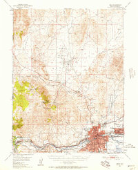 1950 Reno1957 Print · USGSMid-century Reno and Sparks appear here alongside the vital irrigation networks that sustained the Truckee Meadows. Researchers can trace the development of older neighborhoods and outlying sites like Poeville (Site), the Reno Fair Grounds, and Skyline Airfield.3 unique versions available
 - 1951 Map of Reno
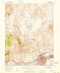 1951 Reno1951 Print · USGSMid-century Nevada comes into focus as Reno and Sparks expand along the Truckee River and transcontinental rail lines. Trace family history and local industry through features like Mtnview Cem, the Golden Fleece Mine, and early aviation at Skyline Airfield.2 unique versions available
 - 1957 Map of Reno, 1963 Print
 1957 Reno1963 Print · USGSWestern Nevada in the early sixties is a land of sprawling desert sinks and rising mountain ranges. Genealogists and historians can trace the rail-and-river network connecting Reno, the mining legacy of Rawhide Mine, and the boundaries of the Pyramid Lake Indian Reservation.5 unique versions available
 - 1959 Map of Reno
 1959 Reno1959 Print · USGSWestern Nevada in the late fifties was a land of expanding military airbases and high-desert irrigation projects. You can trace the lineage of the Comstock era through Carson City, locate the Pony Express Monument, or study the rail networks of the Southern Pacific RR.
 - 1960 Map of Reno
 1960 Reno1960 Print · USGSThe high desert of western Nevada comes alive in this mid-century survey of the Reno-Tahoe region. Genealogists and historians can trace rail lines like the Southern Pacific RR and locate remote outposts such as Olinghouse, Nixon, and the Olinghouse Mine.2 unique versions available
 - 1967 Map of Reno, 1971 Print
 1967 Reno1971 Print · USGSReno and Sparks appear in the late sixties as the Truckee River valley transforms into a major regional hub. Genealogists and local historians can trace family neighborhoods, schools like Maxwell Sch, and landmarks including the Reno-Sparks Indian Colony and Mountain View Cem.4 unique versions available
 - 1974 Map of Reno, 1976 Print
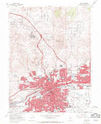
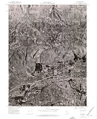 1974 Reno1976 Print · USGSNorthern Nevada during the mid-seventies comes into sharp focus in this aerial study of the growing Reno-Sparks area. Trace the urban sprawl and early infrastructure surrounding Reno, Sparks, and the winding Truckee River.
 - 1980 Map of Reno
 1980 Reno1980 Print · USGSReno and its high-desert surroundings appear in transition during the 1980s, balancing rapid urban expansion with its deep mining and ranching roots. Genealogists and historians can trace the Southern Pacific line through Fernley or locate local landmarks like Mountain View Cem and the Ruth Mine.3 unique versions available
End of results
Showing maps 1-8 of 8
Frequently asked questions
- What are the different types of historical maps available for Powning Addition?
- What is the oldest map of Powning Addition?
- Where can I purchase historical maps of Powning Addition for my home or office?
- Where can I download high-res historical maps of Powning Addition?
- Are there historical topographic maps available for Powning Addition?
- Is there historical aerial imagery available for Powning Addition?
- Where are historical maps of Powning Addition sourced from?