1950s Maps of Shoshone, Nevada
Explore 2 historic maps of Shoshone from the 1950s. These maps offer a rare glimpse into what life looked like during the 1950s — showing old roads, neighborhoods, homes, and landmarks that have changed or disappeared over time.
Whether you're researching your family's past, planning a metal detecting trip, or studying how Shoshone's landscape evolved across the 1950s, these high-resolution maps are a powerful tool for exploring the history of this region.
- Focus on a specific era: All maps on this page are from the 1950s, giving you a focused view of this time period.
- See what’s changed: Compare century-old streets, trails, and buildings to today's modern landscape using overlays and satellite layers.
- Research with precision: Use these maps for genealogy, historical research, land use analysis, or educational projects.
- View, download, or print: Maps are fully viewable online in high resolution, and can be downloaded or printed for your own records.
Start exploring Shoshone's history through authentic maps from the 1950s. This is your window into the past.
Shoshone, NV maps
(2)- 1950 Map of Wheeler Peak
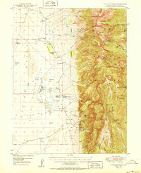 1950 Wheeler Peak1950 Print · USGSEastern Nevada's high-mountain terrain and valley floors come into focus during the late 1940s, showing a landscape shaped by mining and ranching. Genealogists and historians can trace family-held sites like Kirkeby Ranch, find the Shoshone PO Swallow Ranch, and locate various extraction sites including the Everett Mines.2 unique versions available
 - 1956 Map of Lund, 1963 Print
 1956 Lund1963 Print · USGSEastern Nevada and the Utah borderlands are mapped here during the mid-fifties, showing a landscape of high-desert ranches and mountain mining camps. Genealogists and historians can trace family locations through sites like Bristol Silver Mines, Lund, and the Sunnyside Whipple Ranch.2 unique versions available
End of results
Showing maps 1-2 of 2
Frequently asked questions
- What are the different types of historical maps available for Shoshone?
- What is the oldest map of Shoshone?
- Where can I purchase historical maps of Shoshone for my home or office?
- Where can I download high-res historical maps of Shoshone?
- Are there historical topographic maps available for Shoshone?
- Is there historical aerial imagery available for Shoshone?
- Where are historical maps of Shoshone sourced from?