1990s Maps of Moultonborough, New Hampshire
Explore 5 historic maps of Moultonborough from the 1990s. These maps offer a rare glimpse into what life looked like during the 1990s — showing old roads, neighborhoods, homes, and landmarks that have changed or disappeared over time.
Whether you're researching your family's past, planning a metal detecting trip, or studying how Moultonborough's landscape evolved across the 1990s, these high-resolution maps are a powerful tool for exploring the history of this region.
- Focus on a specific era: All maps on this page are from the 1990s, giving you a focused view of this time period.
- See what’s changed: Compare century-old streets, trails, and buildings to today's modern landscape using overlays and satellite layers.
- Research with precision: Use these maps for genealogy, historical research, land use analysis, or educational projects.
- View, download, or print: Maps are fully viewable online in high resolution, and can be downloaded or printed for your own records.
Start exploring Moultonborough's history through authentic maps from the 1990s. This is your window into the past.
Moultonborough, NH maps
(5)- 1995 Map of Center Sandwich, 2000 Print
 1995 Center Sandwich2000 Print · USGSThe Sandwich and Moultonborough area is shown here in the mid-1990s, where the White Mountains meet the northern shores of Squam Lake. Genealogists and historians can trace local homesteads and landmarks like Chicks Corner, Diamond Ledge, and the old cemeteries near Center Sandwich.
 - 1995 Map of Squam Mountains, 2000 Print
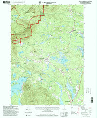
 1995 Squam Mountains2000 Print · USGSThe Squam Mountains and northern lakeshore are captured here in the mid-1990s as hiking trails and summer colonies matured. Researchers can trace the Sandwich Notch Road, find the lakeside Rockywold settlement, and locate the historic Covered Bridge over the Beebe River.
 - 1998 Map of Center Harbor, 1999 Print
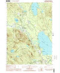
 1998 Center Harbor1999 Print · USGSThe New Hampshire Lakes Region is captured in detail in the late nineties, showing the complex shorelines and islands of the northern reaches. Researchers can trace the development of Center Harbor and Meredith or locate specific island landmarks like Bear Island and Black Cat Island.
 - 1998 Map of Ossipee Lake, 2001 Print
 1998 Ossipee Lake2001 Print · USGSThe Carroll County lake region is captured here in the late nineties, documenting a landscape of mountain peaks and lowland waters. Genealogists and historians can locate old stations at West Ossipee or trace family sites near Moultonville and Dorrs Corner.
 - 1998 Map of Tamworth, 2001 Print
 1998 Tamworth2001 Print · USGSThe Carroll County highlands at the end of the twentieth century show a landscape shaped by the Bearcamp River and the high peaks of the Ossipee Mountains. Genealogists and hikers can locate old settlements like South Tamworth and Whittier or trace the drainage of Cold Brook through the state forests.
End of results
Showing maps 1-5 of 5
Top cities near Moultonborough
- Laconia historical maps
- Gilford historical maps
- Belmont historical maps
- Ossipee historical maps
- Tilton historical maps
- Gilmanton historical maps
See more
Top neighborhoods of Moultonborough
- Gilbert Point historical maps
- Lees Mill historical maps
- Long Point historical maps
- Moultonborough Falls historical maps
- Norway point historical maps
- Cooks Point historical maps
See more
Frequently asked questions
- What are the different types of historical maps available for Moultonborough?
- What is the oldest map of Moultonborough?
- Where can I purchase historical maps of Moultonborough for my home or office?
- Where can I download high-res historical maps of Moultonborough?
- Are there historical topographic maps available for Moultonborough?
- Is there historical aerial imagery available for Moultonborough?
- Where are historical maps of Moultonborough sourced from?