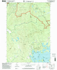
1995 Map of Squam Mountains
USGS Topo · Published 2000About this map
The Squam Mountains and the northern shores of Squam Lake define this high-country landscape in the mid-1990s. The map illustrates a dense network of recreational and historical paths, including the Ridgepole Trail and Doublehead Trail, which traverse prominent peaks like Mount Weetamoo and Doublehead Mountain. Along the shoreline, established summer camps and settlements such as Rockywold and Deephaven sit near protected waters like Carns Cove and Squaw Cove. In the northwest, the Beebe River flows past a historic Covered Bridge near the White Mountain National Forest boundary. The geography is marked by numerous small cemeteries and the transition from mountain wilderness to the many islands of the lake, including Groton Island and Long Island.
Find a feature on this map
87 named features on this map. Tap any name to fly to it.
Don’t see what you’re looking for? This feature index may not catch every label — zoom into the map to look around manually.
Map Details
Editions of this 1995 Squam Mountains Map
This is the sole edition of this map. No revisions or reprints were ever made.
Other maps of this area

1909 · Winnepesaukee
USGS Topo · 1:62,500

1925 · Holderness
USGS Topo · 1:62,500

1927 · Holderness
USGS Topo · 1:62,500

1928 · Plymouth
USGS Topo · 1:62,500

1931 · Plymouth
USGS Topo · 1:62,500

1931 · Mt. Chocorua
USGS Topo · 1:62,500

1949 · Portland
USGS Topo · 1:250,000

1956 · Winnipesaukee
USGS Topo · 1:62,500

1956 · Holderness
USGS Topo · 1:62,500

1956 · Portland
USGS Topo · 1:250,000