1980s Maps of Tuftonboro, New Hampshire
Explore 7 historic maps of Tuftonboro from the 1980s. These maps offer a rare glimpse into what life looked like during the 1980s — showing old roads, neighborhoods, homes, and landmarks that have changed or disappeared over time.
Whether you're researching your family's past, planning a metal detecting trip, or studying how Tuftonboro's landscape evolved across the 1980s, these high-resolution maps are a powerful tool for exploring the history of this region.
- Focus on a specific era: All maps on this page are from the 1980s, giving you a focused view of this time period.
- See what’s changed: Compare century-old streets, trails, and buildings to today's modern landscape using overlays and satellite layers.
- Research with precision: Use these maps for genealogy, historical research, land use analysis, or educational projects.
- View, download, or print: Maps are fully viewable online in high resolution, and can be downloaded or printed for your own records.
Start exploring Tuftonboro's history through authentic maps from the 1980s. This is your window into the past.
Tuftonboro, NH maps
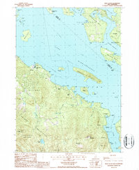
(7)- 1986 Map of Lake Winnipesaukee
 1986 Lake Winnipesaukee1986 Print · USGSThe Lakes Region in the mid-eighties shows a landscape of dense water bodies and mountain ranges at the peak of its twentieth-century character. Trace the legacy of old rail lines like the Boston and Maine RR and locate historic centers from Rumney Depot to Melvin Village.2 unique versions available
 - 1987 Map of Ossipee Lake
 1987 Ossipee Lake1987 Print · USGSCarroll County’s lake country is captured here in the late eighties, showing the transitional landscape between the southern peaks and the central water basin. Researchers can trace historic village centers like Moultonville and Chocorua or locate the seasonal grounds of Camp Weetamoe.
 - 1987 Map of Tuftonboro
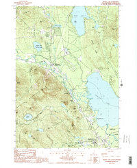
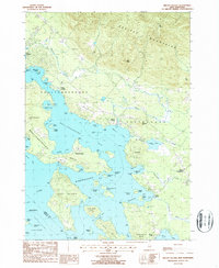
 1987 Tuftonboro1987 Print · USGSTuftonboro and the surrounding New Hampshire highlands are captured here during the late eighties, showing a landscape defined by glacial ponds and small mountain hamlets. Researchers can trace family sites near Water Village, identify old crossroads like Federal Corner, or locate the shores of Dan Hole Pond.
 - 1987 Map of West Alton
 1987 West Alton1987 Print · USGSLake Winnipesaukee's southern reaches were well-defined by the late twentieth century, showing a mix of established summer camps and mountain preserves. Researchers can trace land ownership and community layout around West Alton, Sandy Island Camp, and the historic Mt Washington Boat Route.2 unique versions available
 - 1987 Map of Tamworth
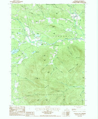 1987 Tamworth1987 Print · USGSCarroll County's mountain-and-river landscape is documented here in the late 1980s, showcasing the development of small New England villages. Researchers can trace historic properties near Tamworth, locate the Covered Bridge, and explore high-elevation landmarks like Black Snout Mtn.2 unique versions available
 - 1987 Map of Melvin Village
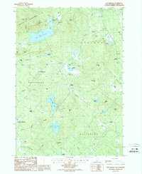
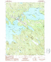
 1987 Melvin Village1987 Print · USGSLake Winnipesaukee's northern shores are captured in the late eighties, showing a landscape defined by historic landings and the transition into the Ossipee Mountains. Genealogists and local historians can trace family locations near Melvin Village, Center Tuftonboro, and the working waterfront at Union Wharf.
 - 1987 Map of Wolfeboro
 1987 Wolfeboro1987 Print · USGSThe Lakes Region of New Hampshire thrives in the late eighties, centered on the bustling resort community of Wolfeboro. Genealogists and historians can trace family-named landmarks like Cates Hill and Hayes Hill, or explore the shorelines of Lake Winnipesaukee and Lake Wentworth.
End of results
Showing maps 1-7 of 7
Top cities near Tuftonboro
- Laconia historical maps
- Gilford historical maps
- Belmont historical maps
- Wakefield historical maps
- Northfield historical maps
- Moultonborough historical maps
See more
Top neighborhoods of Tuftonboro
- Federal Corner historical maps
- Haley Point historical maps
- Hersey Point historical maps
- Melvin Village historical maps
- Millstone Point historical maps
- Mirror Lake historical maps
See more
Frequently asked questions
- What are the different types of historical maps available for Tuftonboro?
- What is the oldest map of Tuftonboro?
- Where can I purchase historical maps of Tuftonboro for my home or office?
- Where can I download high-res historical maps of Tuftonboro?
- Are there historical topographic maps available for Tuftonboro?
- Is there historical aerial imagery available for Tuftonboro?
- Where are historical maps of Tuftonboro sourced from?