1990s Maps of Richmond, New Hampshire
Explore 3 historic maps of Richmond from the 1990s. These maps offer a rare glimpse into what life looked like during the 1990s — showing old roads, neighborhoods, homes, and landmarks that have changed or disappeared over time.
Whether you're researching your family's past, planning a metal detecting trip, or studying how Richmond's landscape evolved across the 1990s, these high-resolution maps are a powerful tool for exploring the history of this region.
- Focus on a specific era: All maps on this page are from the 1990s, giving you a focused view of this time period.
- See what’s changed: Compare century-old streets, trails, and buildings to today's modern landscape using overlays and satellite layers.
- Research with precision: Use these maps for genealogy, historical research, land use analysis, or educational projects.
- View, download, or print: Maps are fully viewable online in high resolution, and can be downloaded or printed for your own records.
Start exploring Richmond's history through authentic maps from the 1990s. This is your window into the past.
Richmond, NH maps
(3)- 1990 Map of Northfield
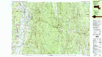 1990 Northfield1990 Print · USGSThe tri-state border of Massachusetts, New Hampshire, and Vermont comes into focus in the 1990s as a landscape of river valleys and forested peaks. Researchers can trace the grounds of the Northfield Mt Hermon School or locate old burial sites like South Parish Cem and Center Cem.2 unique versions available
 - 1998 Map of Troy, 2002 Print
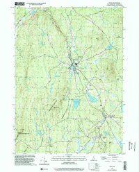 1998 Troy2002 Print · USGSCheshire County at the end of the millennium shows a landscape defined by state forests and historic rail corridors. Researchers can trace the Old Railroad Grade past Fitzwilliam Depot or locate landmarks like the Emerson Sch.
 - 1998 Map of West Swanzey, 2002 Print
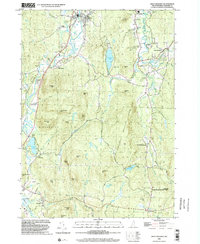 1998 West Swanzey2002 Print · USGSSwanzey and Richmond are shown in the late 1990s as the New Hampshire landscape balances residential growth with large conservation tracts. Trace local genealogy and landmarks through Mt Caesar Cem, the Cutler Sch, and the shoreline of Swanzey Lake.
End of results
Showing maps 1-3 of 3
Top cities near Richmond
- Keene historical maps
- Athol historical maps
- Winchendon historical maps
- Montague historical maps
- Templeton historical maps
- Orange historical maps
See more
Top neighborhoods of Richmond
Frequently asked questions
- What are the different types of historical maps available for Richmond?
- What is the oldest map of Richmond?
- Where can I purchase historical maps of Richmond for my home or office?
- Where can I download high-res historical maps of Richmond?
- Are there historical topographic maps available for Richmond?
- Is there historical aerial imagery available for Richmond?
- Where are historical maps of Richmond sourced from?