Old Maps of Carroll, New Hampshire for Hiking & Exploration
Hike through history with 39 historic maps of Carroll. Explore old trails, ghost towns, and forgotten backroads — perfect for outdoor adventurers and local explorers.
- Rediscover forgotten places: Map out old mining camps, roads, and footpaths that no longer exist on modern maps.
- Layer with modern tools: Combine with LiDAR or satellite views to plan hikes through historical terrain.
- Made for exploration: Popular among hikers, overlanders, and local history lovers.
Use these maps to find adventure and explore the hidden past of Carroll.
Carroll, NH maps
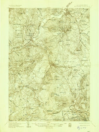
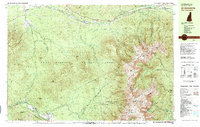
(39)- 1893 Map of Mt. Washington
 1893 Mt. Washington1893 Print · USGSThe Presidential Range and its grand hotels are captured here during the peak of the late-Victorian mountain tourism era. Trace the path of the Mt. Washington Railway or locate early alpine landmarks like Fabyan House, Halfway House, and the AMC Camp.
 - 1895 Map of Crawford Notch
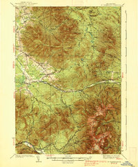
 1895 Crawford Notch1895 Print · USGSThe White Mountains in the mid-1890s are shown here as a landscape of rail-accessible mountain passes and logging outposts. Genealogists and historians can trace the early tourism hubs of Crawford House and Willey House or the industrial roots of Livermore.
 - 1896 Map of Mt. Washington
 1896 Mt. Washington1896 Print · USGSThe Presidential Range at the height of the Victorian tourism era shows a landscape of grand hotels and pioneering alpine engineering. Trace the historic Mt. Washington Railroad to the summit or locate early hospitality landmarks like the Fabyan House and Ravine House.7 unique versions available
 - 1896 Map of Crawford Notch
 1896 Crawford Notch1896 Print · USGSHigh peaks and early railroad travel define this White Mountain landscape in the 1890s. Genealogists and historians can trace the foundations of Livermore, the Maine Central Railroad route, and landmark hotels like the Crawford House.9 unique versions available
 - 1900 Map of Whitefield
 1900 Whitefield1900 Print · USGSWhite Mountains rail and tourism reached a peak at the turn of the century, as seen in this 1897 survey. Trace the old junctions and grand hotels of the era, from the Mount View House to the busy tracks at Whitefield Junction and Wing Road.5 unique versions available
 - 1935 Map of Whitefield
 1935 Whitefield1935 Print · USGSThe White Mountains region in the mid-1930s shows a landscape of busy rail junctions and early aviation fields. Trace old family plots at Baptist Hill Cem or locate vanished structures near Mill Village and Quebec Junction.4 unique versions available
 - 1935 Map of Mt. Washington
 1935 Mt. Washington1935 Print · USGSCoos County at the height of the Great Depression shows a landscape where mountain rail tourism and rugged hiking trails intersect. Trace the path of the Mount Washington Cog Railway or locate old valley sites like Ravine House and the Gore Sch.4 unique versions available
 - 1938 Map of Mt. Washington
 1938 Mt. Washington1938 Print · USGSThe White Mountains in the late 1930s reveal a landscape of mountain resorts and rugged timber camps. Trace the Mount Washington Cog RR, find the Gore Sch, or explore early trail networks like the Crawford Path and Gulfside Trail.4 unique versions available
 - 1938 Map of Whitefield
 1938 Whitefield1938 Print · USGSCoos County at the end of the Great Depression was a landscape of mountain rail junctions and valley farms. Trace the vanished railroad stops at Quebec Junction, locate family homesteads near Baptist Hill Sch, or find the CCC Camp at Pierce Bridge.3 unique versions available
 - 1946 Map of Crawford Notch, 1955 Print
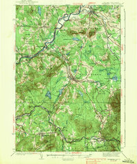
 1946 Crawford Notch1955 Print · USGSThe White Mountains in the mid-1940s reveal a network of historic rail corridors and backcountry shelters. Trace the Maine Central Railroad through the notch or locate early landmarks like Crawford House and the Willey House P.O.9 unique versions available
 - 1950 Map of Crawford Notch
 1950 Crawford Notch1950 Print · USGSGrafton and Carroll Counties are shown here during the mid-century peak of White Mountain hiking and rail travel. Researchers can trace historic trails like the Davis Path, find old mountain outposts like Willey House PO, or locate the logging settlement of Livermore.3 unique versions available
 - 1950 Map of Lewiston
 1950 Lewiston1950 Print · USGSThe Maine and New Hampshire borderlands come alive in this post-war survey of the White Mountains and Androscoggin valley. Genealogists and historians can trace rail lines like the Maine Central Railroad and find high-altitude landmarks from Mount Washington to Bretton Woods.2 unique versions available
 - 1956 Map of Lewiston, 1975 Print
 1956 Lewiston1975 Print · USGSThe Northern New England interior is documented here in the mid-fifties, from the industrial Androscoggin River to the high peaks of the White Mountains. Trace the Grand Trunk Railway through mountain passes or locate family landmarks near Sabbathday Lake and Bretton Woods.
 - 1961 Map of Lewiston
 1961 Lewiston1961 Print · USGSWestern Maine and the White Mountains appear here during the early sixties, showing the industrial river towns and vast timberlands before the modern interstate era. Genealogists and historians can trace the Grand Trunk RR through Berlin or locate landmarks like Old Speck Mountain and Elephant Mountain.
 - 1962 Map of Lewiston
 1962 Lewiston1962 Print · USGSThe industrial river valleys and high peaks of Maine and New Hampshire define the region in the early sixties. Trace the rail-and-river network from Lewiston to the White Mountains, passing through mill towns like Berlin and Rumford.
 - 1969 Map of Lewiston
 1969 Lewiston1969 Print · USGSThe northern New England highlands come into focus during the mid-fifties, showing the vital rail and river networks connecting industrial centers to the deep woods. Researchers can trace the path of the Grand Trunk RR or locate landmarks like Mt Washington and Rangeley Lake.
 - 1982 Map of Bethlehem, 1983 Print
 1982 Bethlehem1983 Print · USGSUpper Grafton and Coos County are shown in the early eighties as the mountain rail corridors still shaped local life. Genealogists and hikers can trace old family burial sites like Burns Cem, follow the Boston and Maine Railroad, or locate the Twin Mountain Fish Hatchery.
 - 1982 Map of Mt. Washington, 1983 Print
 1982 Mt. Washington1983 Print · USGSThe Presidential Range and its iconic summit are captured here in the early eighties, showing the region as a mature hub for mountain tourism and transit. Trace the historic paths of the Mount Washington Cog Railway, explore the high-altitude Lakes of the Clouds, and locate the Lady of the Mountain Ch at Bretton Woods.2 unique versions available
 - 1986 Map of Mount Washington
 1986 Mount Washington1986 Print · USGSThe northern New England highlands are shown here in the mid-eighties, centered on the high peaks and river valleys of the New Hampshire borderlands. Researchers can trace historic transportation lines like the Mount Washington Cog Railway and the Maine Central Railroad near Gorham and Lancaster.
 - 1987 Map of Crawford Notch
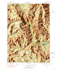
 1987 Crawford Notch1987 Print · USGSGrafton County's mountainous pass is captured in the late eighties, documenting the historical lodgings and expansive trail networks of the White Mountains. Local historians can trace the sites of Crawford House and Willey House, or locate the scenic Arethusa Falls and Zealand Falls among the peaks.
 - 1988 Map of Mount Washington, 1989 Print
 1988 Mount Washington1989 Print · USGSThe New Hampshire high country in the late 1980s is defined by its iconic peaks and the legacy of mountain tourism. Trace the routes of the historic Mount Washington Cog Railway and the Maine Central RR through the gaps of Crawford Notch State Park.
 - 1995 Map of Mount Dartmouth, 2000 Print
 1995 Mount Dartmouth2000 Print · USGSThe high peaks and resort valleys of the White Mountains are shown here in the mid-1990s as the regional landscape balanced tourism and conservation. Researchers can trace historic land grants and local landmarks like Bretton Woods, Fabyan, and Mount Dartmouth.
 - 1995 Map of Twin Mountain, 2000 Print
 1995 Twin Mountain2000 Print · USGSIn the mid-1990s, the rural landscapes of Coos County were shaped by the historic MAINE CENTRAL railroad and the AMMONOOSUC RIVER. Genealogists and researchers can trace the roads to Carroll Cemetery, the Twin Mountain Fish Hatchery, and the rail nexus at Quebec Junction.
 - 1995 Map of Crawford Notch, 2000 Print
 1995 Crawford Notch2000 Print · USGSGrafton and Carroll Counties are shown here during the mid-nineties, capturing the extensive trail systems and wilderness boundaries of the White Mountains. Hikers and historians can trace the Appalachian National Scenic Trail past Zealand Falls or locate the historic Willey House (Site).
 - 2012 Map of Crawford Notch, 2012 Print
 2012 Crawford Notch2012 Print · USGSCovers Carroll, including Lincoln, Bethlehem, and other nearby areas
Showing maps 1-25 of 39
Top cities near Carroll
- Berlin historical maps
- Littleton historical maps
- Lancaster historical maps
- Bartlett historical maps
- Whitefield historical maps
- Northumberland historical maps
See more
Top neighborhoods of Carroll
- Fabyan historical maps
- Twin Mountain historical maps
- Bretton Woods historical maps
- Quebec Junction historical maps
Frequently asked questions
- What are the different types of historical maps available for Carroll?
- What is the oldest map of Carroll?
- Where can I purchase historical maps of Carroll for my home or office?
- Where can I download high-res historical maps of Carroll?
- Are there historical topographic maps available for Carroll?
- Is there historical aerial imagery available for Carroll?
- Where are historical maps of Carroll sourced from?