Old Maps of Grafton County, New Hampshire for Genealogy
Trace your family roots with 360 historic maps of Grafton County. These high-res maps reveal old neighborhoods, homesites, landmarks, and streets — helping you uncover where your ancestors lived and how the area evolved over time.
- Explore historic neighborhoods: Identify where your relatives may have lived in the 1800s or 1900s.
- Compare maps over time: Trace the changes in streets, buildings, and landmarks for multi-generational research.
- Perfect for genealogy & ancestry research: Used by family historians and researchers to map out lineage and migration.
These maps are an incredible resource for exploring your personal connection to Grafton County's past.
Grafton County, NH maps
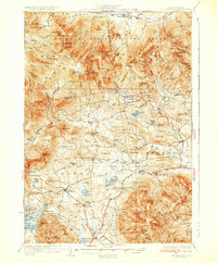
(360)- 1893 Map of Mt. Washington
 1893 Mt. Washington1893 Print · USGSThe Presidential Range and its grand hotels are captured here during the peak of the late-Victorian mountain tourism era. Trace the path of the Mt. Washington Railway or locate early alpine landmarks like Fabyan House, Halfway House, and the AMC Camp.
 - 1895 Map of Crawford Notch
 1895 Crawford Notch1895 Print · USGSThe White Mountains in the mid-1890s are shown here as a landscape of rail-accessible mountain passes and logging outposts. Genealogists and historians can trace the early tourism hubs of Crawford House and Willey House or the industrial roots of Livermore.
 - 1896 Map of Mt. Washington
 1896 Mt. Washington1896 Print · USGSThe Presidential Range at the height of the Victorian tourism era shows a landscape of grand hotels and pioneering alpine engineering. Trace the historic Mt. Washington Railroad to the summit or locate early hospitality landmarks like the Fabyan House and Ravine House.7 unique versions available
 - 1896 Map of Crawford Notch
 1896 Crawford Notch1896 Print · USGSHigh peaks and early railroad travel define this White Mountain landscape in the 1890s. Genealogists and historians can trace the foundations of Livermore, the Maine Central Railroad route, and landmark hotels like the Crawford House.9 unique versions available
 - 1900 Map of Whitefield
 1900 Whitefield1900 Print · USGSWhite Mountains rail and tourism reached a peak at the turn of the century, as seen in this 1897 survey. Trace the old junctions and grand hotels of the era, from the Mount View House to the busy tracks at Whitefield Junction and Wing Road.5 unique versions available
 - 1906 Map of Hanover, 1956 Print
 1906 Hanover1956 Print · USGSThe Upper Connecticut River Valley at the turn of the century is a hub of rail activity and collegiate life. Researchers can trace the early footprints of Dartmouth College or locate vanished rail infrastructure at White River Junction and Deweys Mills.2 unique versions available
 - 1908 Map of Hanover
 1908 Hanover1908 Print · USGSThe Upper Valley at the dawn of the twentieth century was a vital junction of Vermont and New Hampshire rail lines and river commerce. Researchers can trace the early layout of Dartmouth College, the rail yards of White River Junction, and numerous rural schoolhouses like Podunk School.7 unique versions available
 - 1925 Map of Holderness, 1956 Print
 1925 Holderness1956 Print · USGSCentral New Hampshire in the mid-twenties centers on the Pemigewasset River and the bustling rail corridor. Genealogists can trace a network of rural schoolhouses like Sargent School and landmarks including Profile Falls and the Bay Meeting House.
 - 1927 Map of Holderness
 1927 Holderness1927 Print · USGSThe Lakes Region in the late twenties reveals a landscape of small hill-town schools and winding river valleys. Genealogists can locate family landmarks like Sargent School, Dana Church, and numerous small waters from Squam Lake to Wickwas Pond.6 unique versions available
 - 1927 Map of Cardigan, 1957 Print
 1927 Cardigan1957 Print · USGSGrafton and Merrimack Counties were defined by rail-side industry and early lakeside tourism in the late 1920s. Genealogists and historians can trace defunct schoolhouses like School No 8 and find deep-woods sites like the Alexandria Mica Mine.
 - 1927 Map of Mascoma, 1957 Print
 1927 Mascoma1957 Print · USGSGrafton County's hill towns and valleys are caught in detail during the late 1920s, showing the settled character of the New Hampshire interior. Genealogists can trace family names through landmarks like Washburn Corner or locate the distinctive Lower Shaker Village and Upper Shaker Village.3 unique versions available
 - 1928 Map of Plymouth, 1953 Print
 1928 Plymouth1953 Print · USGSGrafton County is captured in the late 1920s as its river towns and mountain resorts began to modernize. Genealogists can trace family footprints at Blair Cemetery or locate old schoolhouses like Pulsifer Hill Sch and Thornton Center Sch along the valley roads.5 unique versions available
 - 1928 Map of Rumney, 1955 Print
 1928 Rumney1955 Print · USGSGrafton County is shown here in the late twenties as a bustling corridor of rail and river industry. Genealogists can trace the rural schoolhouses and stops along the Boston and Maine Railroad, from West Rumney PO to the logging outposts at Camp No 5.3 unique versions available
 - 1929 Map of Moosilauke, 1959 Print
 1929 Moosilauke1959 Print · USGSGrafton County's upland townships and the White Mountain National Forest are shown here in the late twenties during a period of mountain transition. Locate family landmarks and vanished crossroads like Oliverian Sta, Swiftwater, and several rural schools including Brier Hill Sch.
 - 1929 Map of Franconia, 1963 Print
 1929 Franconia1963 Print · USGSThe White Mountains come alive in the late 1920s, showing the early infrastructure of logging and tourism before modern highway expansions. Trace the Boston and Maine RR into Lincoln, or locate local landmarks like The Profile and the Profile Golf Club.2 unique versions available
 - 1930 Map of Cardigan
 1930 Cardigan1930 Print · USGSGrafton County's granite hills and lakeside settlements are captured here in the late prohibition era. Genealogists and hikers can trace the original locations of rural schoolhouses like Crawford Sch, the workings of the Alexandria Mica Mines, and the old rail stops at Grafton Sta.7 unique versions available
 - 1931 Map of Mt. Cube
 1931 Mt. Cube1931 Print · USGSThe Connecticut River valley and the foothills of the White Mountains are shown here as they appeared in the early 1930s. Genealogists and hikers can trace the Appalachian Trail, locate rural schools like Blood Brook Sch, or find family sites near Quinttown.3 unique versions available
 - 1931 Map of Littleton
 1931 Littleton1931 Print · USGSUpper Connecticut River Valley life is recorded here in the early thirties, just as aerial photography began to modernize topographic surveying. Genealogists can locate family-named hills and district schools like the Walker Hill Sch and Gilmanton Sch.2 unique versions available
 - 1931 Map of Plymouth
 1931 Plymouth1931 Print · USGSGrafton County communities are linked by the Boston and Maine Railroad during the early thirties. Genealogists can trace family roots through numerous rural landmarks like Thornton Center, Blair Sch, and the riverside landings at Livermore Falls.5 unique versions available
 - 1931 Map of Woodsville
 1931 Woodsville1931 Print · USGSThe Upper Connecticut River Valley in the early 1930s reveals a landscape of riverside rail towns and debated state boundaries. Genealogists and historians can trace the foundations of local life through labels like the North Monroe Ch, Blackmount Sta, and the County Poor Farm.
 - 1931 Map of Mt. Chocorua
 1931 Mt. Chocorua1931 Print · USGSCarroll County’s timber and mountain landscape is captured here in the late Prohibition era. Researchers can trace the path of the Beebe River RR, locate old schoolhouses like Fellows Sch, and find family sites near Wonalancet or Center Sandwich.7 unique versions available
 - 1932 Map of Franconia
 1932 Franconia1932 Print · USGSThe White Mountains in the early 1930s reveal a landscape caught between industrial timbering and the rise of mountain tourism. Researchers can trace the path of the Logging RR or locate family landmarks like the Russell Farm and Fairview.5 unique versions available
 - 1932 Map of Mascoma
 1932 Mascoma1932 Print · USGSGrafton County in the early thirties shows a unique landscape of communal settlements and rugged upland farms. Genealogists can trace family roots through numerous local schoolhouses and rural hamlets like Hanover Center and Lower Shaker Village.5 unique versions available
 - 1932 Map of Rumney
 1932 Rumney1932 Print · USGSThe Baker River valley in the early 1930s shows a landscape of mountain rail stops and rural schoolhouses. Genealogists can trace family landmarks and forgotten stops like Swainboro Sta, Weeks Crossing, and the Buffalo Sch.5 unique versions available
 - 1932 Map of Littleton
 1932 Littleton1932 Print · USGSThe Upper Connecticut River valley and the hills of Vermont's Northeast Kingdom appear here in the early thirties. Trace family connections through numerous rural schoolhouses like Sugar Hill Sch or locate the old Kirby Mtn Quarries and the original path of the Maine Central Railroad.3 unique versions available
Showing maps 1-25 of 360
Top cities of Grafton County
- Lebanon historical maps
- Hanover historical maps
- Littleton historical maps
- Plymouth historical maps
- Enfield historical maps
- Haverhill historical maps
See more
Frequently asked questions
- What are the different types of historical maps available for Grafton County?
- What is the oldest map of Grafton County?
- Where can I purchase historical maps of Grafton County for my home or office?
- Where can I download high-res historical maps of Grafton County?
- Are there historical topographic maps available for Grafton County?
- Is there historical aerial imagery available for Grafton County?
- Where are historical maps of Grafton County sourced from?