1900s (20th Century) Maps of Mason, New Hampshire
Explore 30 historic maps of Mason from the 1900s (20th Century). These maps offer a rare glimpse into what life looked like during the 1900s — showing old roads, neighborhoods, homes, and landmarks that have changed or disappeared over time.
Whether you're researching your family's past, planning a metal detecting trip, or studying how Mason's landscape evolved across the 1900s, these high-resolution maps are a powerful tool for exploring the history of this region.
- Focus on a specific era: All maps on this page are from the 1900s, giving you a focused view of this time period.
- See what’s changed: Compare century-old streets, trails, and buildings to today's modern landscape using overlays and satellite layers.
- Research with precision: Use these maps for genealogy, historical research, land use analysis, or educational projects.
- View, download, or print: Maps are fully viewable online in high resolution, and can be downloaded or printed for your own records.
Start exploring Mason's history through authentic maps from the 1900s. This is your window into the past.
Mason, NH maps
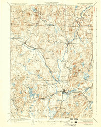
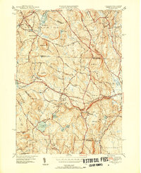
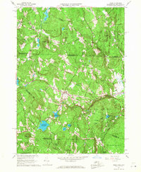
(30)- 1900 Map of Peterboro
 1900 Peterboro1900 Print · USGSHillsborough County villages and mountain ranges come into sharp focus during the late Victorian era as rail lines expanded through the valley. Researchers can trace the Boston and Maine RR corridors and locate family landmarks from Peterboro to New Ipswich and Lithia Spring.9 unique versions available
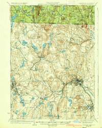
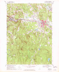
 - 1906 Map of Milford
 1906 Milford1906 Print · USGSHillsborough County at the turn of the century is a landscape of thriving river towns and expanding rail lines. You can trace early 1900s family homesteads near Joe English Hill, visit the waters of Milford Springs, or locate the old Laurel PO.8 unique versions available
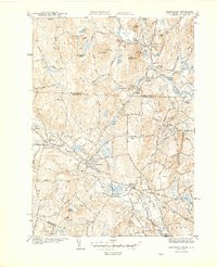
 - 1931 Map of Groton
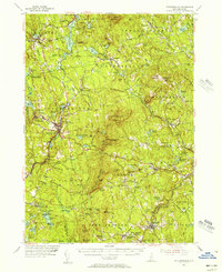
 1931 Groton1931 Print · USGSThe Massachusetts and New Hampshire borderlands in the early thirties reveal a landscape of river-powered rail and rural industry. Genealogists can trace family landmarks and transport hubs like Hollis Sta, Potanopa Pond, and the Runnels Bridge.
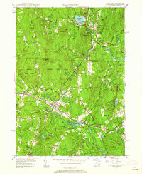
 - 1931 Map of Fitchburg
 1931 Fitchburg1931 Print · USGSThe Massachusetts and New Hampshire border region was a network of mill villages and mountain ridges in the early thirties. Genealogists and historians can locate rural landmarks like School No 8, the High Bridge, and the Boston and Maine rail line.
 - 1935 Map of Groton
 1935 Groton1935 Print · USGSCrossing the New Hampshire border in the 1930s, this area was a bustling hub of rail transport and riverside industry. Researchers can trace the legacy of communal life at Shaker Village, locate the campus of Groton School, or follow the lines of the Boston and Maine RR through towns like Pepperell and Shirley.
 - 1935 Map of Fitchburg
 1935 Fitchburg1935 Print · USGSThe industrial corridor and border hills of north-central Massachusetts and southern New Hampshire are captured here in the mid-1930s. Trace the intricate rail networks of the Old Colony Railroad and find local landmarks like School No 8 or Rollstone Hill.3 unique versions available
 - 1936 Map of Groton
 1936 Groton1936 Print · USGSNorthern Middlesex County and southern New Hampshire appear here in the mid-1930s, showing a landscape shaped by river power and a dense rail network. Researchers can trace historic sites like the Shaker Village and Groton School, or locate old depots at Townsend Harbor and Ayer.3 unique versions available
 - 1936 Map of Fitchburg
 1936 Fitchburg1936 Print · USGSNorthwestern Massachusetts and southern New Hampshire are shown here during the mid-1930s, featuring a mature network of rail lines and industrial river towns. Genealogists can locate family landmarks like School No 9 or trace the early paths of the Fitchburg Railroad and Old Colony Railroad Fitchburg Branch.2 unique versions available
 - 1943 Map of Fitchburg
 1943 Fitchburg1943 Print · USGSSouthern New Hampshire and northern Massachusetts are captured during the war years, showing a landscape of river-powered mill towns and mountain trails. You can trace family roots in Peterboro, locate the historic Groton School, or study the rail lines of the Boston & Maine RR.
 - 1944 Map of Townsend
 1944 Townsend1944 Print · USGSTownsend and Brookline sit at the heart of this mid-century New England landscape as the rail era transitioned toward the modern highway. Researchers can trace the Boston and Maine RR line through Townsend Harbor and find family names at Pine Grove Cem or Center Cem.4 unique versions available
 - 1946 Map of Ashby
 1946 Ashby1946 Print · USGSThe borderlands of New Hampshire and Massachusetts are captured in the mid-1940s, showing a network of upland farms and timbered hills. You can trace family roots through landmarks like Gibson Four Corners, find old burials at Glenwood Cem, or locate the rail stop at Mason Sta.2 unique versions available
 - 1948 Map of Boston
 1948 Boston1948 Print · USGSEastern Massachusetts and southern New Hampshire appear at an industrial peak in the late 1940s, just as suburban growth began to accelerate. Genealogists and historians can trace rail lines like the Boston and Albany RR or locate coastal landmarks like Graves Lighthouse and Fort Devens.2 unique versions available
 - 1950 Map of Townsend, 1952 Print
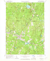
 1950 Townsend1952 Print · USGSMid-century Middlesex County and southern New Hampshire centers on the rail-and-river corridor of Townsend. Genealogists and historians can trace the Boston and Maine Railroad through Townsend Harbor and locate family sites like Hillside Cem and Barker Hill.2 unique versions available
 - 1950 Map of Ashby, 1952 Print
 1950 Ashby1952 Print · USGSThe Massachusetts-New Hampshire borderlands near Ashby are captured in the mid-twentieth century as the region balanced its rural character with state forest expansion. Genealogists can locate family sites near Glenwood Cem, the Lyman Sch, and the old rail stop at Mason Sta.4 unique versions available
 - 1953 Map of Fitchburg
 1953 Fitchburg1953 Print · USGSMid-century Worcester County comes to life during a period of steady growth and established rail commerce. Local historians can trace family roots at Prospect Hill Cemetery or explore the development of Blackburne Village and the Fitchburg Leominster Airport.
 - 1953 Map of Peterborough, 1956 Print
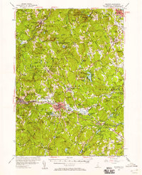
 1953 Peterborough1956 Print · USGSHillsborough County in the mid-fifties is captured here as a region of mill towns and mountain trails during a period of steady growth. Researchers can locate family landmarks like the Edward MacDowell Grave, trace the Boston and Maine Railroad, or find old school sites like Appleton Academy.3 unique versions available
 - 1953 Map of Milford, 1958 Print
 1953 Milford1958 Print · USGSHillsborough County in the early fifties shows a landscape of growing towns and established institutions. Trace family roots and local history near Milford or explore the mid-century layout of St Anselms College and the Baboosic Lake shoreline.3 unique versions available
 - 1956 Map of Boston, 1967 Print
 1956 Boston1967 Print · USGSThe Massachusetts coastline and industrial interior are seen here during the mid-century peak of suburban and highway expansion. Researchers can trace historic harbor defenses like Fort Revere, local landmarks such as Faneuil Hall, and the vast Parker River National Wildlife Refuge.6 unique versions available
 - 1958 Map of Boston
 1958 Boston1958 Print · USGSEastern Massachusetts and southern New Hampshire are shown at the height of the industrial era, before the full expansion of the interstate system. Trace coastal defenses at Fort Warren, historic rail lines like the Boston and Maine, and the development of the Mass. 128 corridor.2 unique versions available
 - 1961 Map of Boston
 1961 Boston1961 Print · USGSThe Massachusetts coastline and its industrial interior are detailed here in the mid-twentieth century, from the Monadnock highlands to Cape Cod. Researchers can trace the rail routes of the Boston and Maine or locate landmarks like Fort Devens and the Wachusett Reservoir.2 unique versions available
 - 1965 Map of Townsend, 1967 Print
 1965 Townsend1967 Print · USGSTownsend and Brookline are captured in the mid-1960s as the rail and river corridor through the Squannacook River valley remained central to local life. Researchers can trace historic family landmarks and civic sites like Lakeview Cem, Daniels Academy, and the Boston and Maine rail line.5 unique versions available
 - 1965 Map of Ashby, 1968 Print
 1965 Ashby1968 Print · USGSThe hill towns of the Massachusetts borderlands are captured here in the mid-1960s, showing a landscape of state forests and quiet village centers. Genealogists can locate family plots in Glenwood Cem or West Cem and trace the paths through South Village and Gibson Four Corners.4 unique versions available
 - 1968 Map of Milford, 1971 Print
 1968 Milford1971 Print · USGSHillsborough County towns thrive along the river and rail corridors of South Central New Hampshire during the late sixties. Genealogists and hikers can trace family plots at Riverside Cemetery or scout the landscape from the Federal Hill Lookout Tower and Purgatory Falls.3 unique versions available
 - 1975 Map of Townsend, 1981 Print
 1975 Townsend1981 Print · USGSMiddlesex County's rural northern reaches are captured in the mid-seventies, showing the density of forest and river-valley settlements. Trace the residential layouts of Townsend, Old City, and the banks of the Squannacook River.
 - 1984 Map of Lowell
 1984 Lowell1984 Print · USGSThe Merrimack Valley industrial corridor is captured here in the mid-eighties, showing the interconnected growth of Lowell, Nashua, and Lawrence. Genealogists and historians can trace the paths of the Boston and Maine railroad or locate institutional landmarks like Merrimack College and the Fort Devens Military Reservation.
Showing maps 1-25 of 30
Top cities near Mason
- Nashua historical maps
- Leominster historical maps
- Fitchburg historical maps
- Merrimack historical maps
- Gardner historical maps
- Bedford historical maps
See more
Frequently asked questions
- What are the different types of historical maps available for Mason?
- What is the oldest map of Mason?
- Where can I purchase historical maps of Mason for my home or office?
- Where can I download high-res historical maps of Mason?
- Are there historical topographic maps available for Mason?
- Is there historical aerial imagery available for Mason?
- Where are historical maps of Mason sourced from?