1980s Maps of Canterbury, New Hampshire
Explore 7 historic maps of Canterbury from the 1980s. These maps offer a rare glimpse into what life looked like during the 1980s — showing old roads, neighborhoods, homes, and landmarks that have changed or disappeared over time.
Whether you're researching your family's past, planning a metal detecting trip, or studying how Canterbury's landscape evolved across the 1980s, these high-resolution maps are a powerful tool for exploring the history of this region.
- Focus on a specific era: All maps on this page are from the 1980s, giving you a focused view of this time period.
- See what’s changed: Compare century-old streets, trails, and buildings to today's modern landscape using overlays and satellite layers.
- Research with precision: Use these maps for genealogy, historical research, land use analysis, or educational projects.
- View, download, or print: Maps are fully viewable online in high resolution, and can be downloaded or printed for your own records.
Start exploring Canterbury's history through authentic maps from the 1980s. This is your window into the past.
Canterbury, NH maps
(7)- 1986 Map of Concord
 1986 Concord1986 Print · USGSCentral New Hampshire in the mid-eighties shows a landscape of river-valley cities and rural villages connected by the growing interstate system. Genealogists and historians can trace old community centers like Gilmanton Ironworks or follow the Boston and Maine Railroad through Concord and Tilton.
 - 1987 Map of Penacook
 1987 Penacook1987 Print · USGSThe Merrimack and Contoocook rivers converge near Penacook in the late eighties, showing a landscape shaped by river power and early rail. Genealogists and local historians can trace family-named features like Cogswell Hill, Morrill Pond, and the Hannah Dustin Historical Site.
 - 1987 Map of Belmont
 1987 Belmont1987 Print · USGSBelknap County at the close of the eighties shows a landscape of deep forests and quiet mill towns. Genealogists and local historians can trace family-named sites like Aliens Mills, Jones Mills, and the heights of Loudon Ridge.
 - 1987 Map of Northfield
 1987 Northfield1987 Print · USGSThe twin towns of Tilton and Northfield straddle the river in the late 1980s, showing a landscape shaped by water and industry. Researchers can trace historic property lines near Ayers State Forest or locate early settlements like Sanbornton and Lochmere.
 - 1987 Map of Loudon
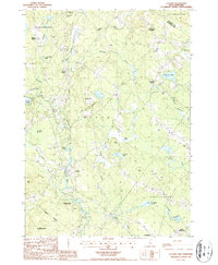 1987 Loudon1987 Print · USGSMerrimack County in the late 1980s reveals a landscape of enduring village centers and river-fed forests. Researchers can trace the heritage of Shaker Village, locate the waters of Carding Mill Pond, and explore the hills around Loudon Center.2 unique versions available
 - 1987 Map of Webster
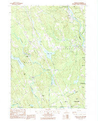 1987 Webster1987 Print · USGSMerrimack County in the late eighties shows a landscape of river-driven industry and quiet crossroads settlements. Researchers can trace historic sites like Snyders Mill and Swetts Mills, or locate family landmarks near Dingit Corner and Putney Hill.2 unique versions available
 - 1988 Map of Concord
 1988 Concord1988 Print · USGSCentral New Hampshire in the late eighties centers on the industrial and political hub of Concord. Researchers can trace the Boston and Maine RR along the Merrimack River or locate recreation landmarks like Bear Brook State Park and Massabesic Lake.
End of results
Showing maps 1-7 of 7
Top cities near Canterbury
- Concord historical maps
- Laconia historical maps
- Weare historical maps
- Franklin historical maps
- Gilford historical maps
- Bow historical maps
See more
Top neighborhoods of Canterbury
- Shaker Village historical maps
- Canterbury Station historical maps
- Boyce historical maps
- Kezer Seminary historical maps
- Hills Corner historical maps
Frequently asked questions
- What are the different types of historical maps available for Canterbury?
- What is the oldest map of Canterbury?
- Where can I purchase historical maps of Canterbury for my home or office?
- Where can I download high-res historical maps of Canterbury?
- Are there historical topographic maps available for Canterbury?
- Is there historical aerial imagery available for Canterbury?
- Where are historical maps of Canterbury sourced from?