1950s Maps of Rockingham County, New Hampshire
Explore 31 historic maps of Rockingham County from the 1950s. These maps offer a rare glimpse into what life looked like during the 1950s — showing old roads, neighborhoods, homes, and landmarks that have changed or disappeared over time.
Whether you're researching your family's past, planning a metal detecting trip, or studying how Rockingham County's landscape evolved across the 1950s, these high-resolution maps are a powerful tool for exploring the history of this region.
- Focus on a specific era: All maps on this page are from the 1950s, giving you a focused view of this time period.
- See what’s changed: Compare century-old streets, trails, and buildings to today's modern landscape using overlays and satellite layers.
- Research with precision: Use these maps for genealogy, historical research, land use analysis, or educational projects.
- View, download, or print: Maps are fully viewable online in high resolution, and can be downloaded or printed for your own records.
Start exploring Rockingham County's history through authentic maps from the 1950s. This is your window into the past.
Rockingham County, NH maps
(31)- 1950 Map of Dover East
 1950 Dover East1950 Print · USGSThe borderlands of New Hampshire and Maine are captured here at mid-century, following the winding Salmon Falls River through a landscape of rail-connected towns. Researchers can trace historic cemeteries and schools such as Pine Hill Cem, Pear Yard School, and the junction at Eliot Depot.
 - 1950 Map of Exeter, 1952 Print
 1950 Exeter1952 Print · USGSCoastal New Hampshire's rural character and established town centers are captured here at mid-century, just as local road networks began to expand. Researchers can trace ancestral roots through family-named landmarks like Gooch Corner, Dows Corner, and the Westview Cem.5 unique versions available
 - 1950 Map of Lowell, 1953 Print
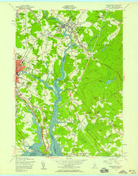
 1950 Lowell1953 Print · USGSMid-century Lowell is a bustling center of industry and education at the bend of the Merrimack River. Researchers can trace the era's infrastructure from the Pawtucket Dam to institutions like Keith Academy and the Lowell Textile Institute.4 unique versions available
 - 1952 Map of Portsmouth
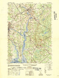
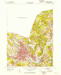
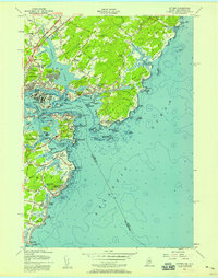
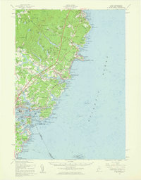
 1952 Portsmouth1952 Print · USGSCoastal New Hampshire and Maine are shown in detail during the early fifties, centering on the harbor and the bustling city of Portsmouth. Trace the development of the Piscataqua River waterfront, find ancestral sites like Winnicut Mills, and locate old rail hubs at Greenland Station or Newington Station.
 - 1952 Map of Haverhill, 1953 Print
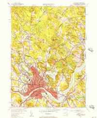
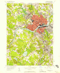
 1952 Haverhill1953 Print · USGSHaverhill and the Merrimack River valley are captured in the early fifties, showing a thriving industrial city and its surrounding hill country. Genealogists can locate family names and sites across Bradford Junior College, Whittier Birthplace, and several local schools.2 unique versions available
 - 1952 Map of Ayers Village, 1953 Print
 1952 Ayers Village1953 Print · USGSThe borderlands of Rockingham County and Essex County come into focus in the early fifties as the region's post-war identity took shape. Genealogists and researchers can trace family-named corners and community landmarks like Ayers Village, Tozier Corner, and the Howe Sch.
 - 1952 Map of Newburyport West, 1953 Print
 1952 Newburyport West1953 Print · USGSThe Merrimack River valley in the early fifties shows a landscape of established river towns and growing transit corridors. Genealogists can locate family burial sites at Sawyers Hill Burying Ground or trace the early campus of Governor Dummer Academy.4 unique versions available
 - 1952 Map of Newburyport East, 1954 Print
 1952 Newburyport East1954 Print · USGSCoastal Massachusetts and New Hampshire meet at the mouth of the Merrimack River during the early fifties, where maritime commerce and conservation intersect. Researchers can trace ancestral sites at the First Burial Ground or locate vanished landmarks like Butlers Toothpick and Woodbridge Sch.3 unique versions available
 - 1953 Map of Windham, 1956 Print
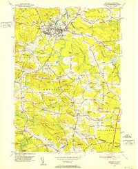
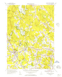
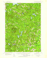
 1953 Windham1956 Print · USGSSoutheastern New Hampshire was still largely rural in the mid-1950s as small communities centered around the rails and lakes. Genealogists and local historians can trace family locations near Cobbetts Pond or find landmarks like Windham Depot and the Searles Sch.5 unique versions available
 - 1953 Map of Manchester, 1958 Print
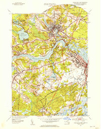
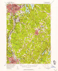 1953 Manchester1958 Print · USGSSouthern New Hampshire thrives in the early fifties as industrial cities and military installations like Grenier Air Force Base anchor the Merrimack Valley. Trace ancestral roots at St Josephs Cem or locate old river crossings like Thorntons Ferry.4 unique versions available
 - 1955 Map of Ayers Village, 1956 Print
 1955 Ayers Village1956 Print · USGSThe New Hampshire-Massachusetts state line comes alive in the 1950s as suburban growth meets traditional landscapes. Researchers can trace family roots at Salem Depot, locate the historic West Parish Ch, and explore landmarks like Rockingham Park.3 unique versions available
 - 1955 Map of Haverhill, 1957 Print
 1955 Haverhill1957 Print · USGSHaverhill and Bradford sit at a crossroads of industry and education along the Merrimack River during the mid-fifties. Researchers can trace the legacy of local institutions like Bradford Junior College, find the Whittier Birthplace, and locate numerous neighborhood schools and cemeteries.2 unique versions available
 - 1955 Map of Lawrence, 1958 Print
 1955 Lawrence1958 Print · USGSMid-century Lawrence and Andover center on the bustling Merrimack Valley during a period of robust industrial and academic growth. Genealogists and historians can trace the campuses of Phillips Academy, the planned streets of Shawsheen Village, and various local burial sites like Bellevue Cemetery.
 - 1956 Map of Kittery, 1957 Print
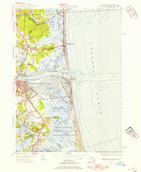
 1956 Kittery1957 Print · USGSThe Maine and New Hampshire coastlines meet here in the mid-1950s, a landscape shaped by centuries of maritime defense and growing suburban neighborhoods. Genealogists and historians can trace the foundations of Kittery and New Castle, locating landmarks like Fort McClary State Park and the Whaleback Lighthouse.5 unique versions available
 - 1956 Map of Isles Of Shoals, 1957 Print
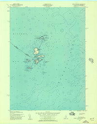 1956 Isles Of Shoals1957 Print · USGSThe offshore islands of York County and Rockingham County are captured in this mid-century maritime survey. Genealogists and historians can trace the settlement of Gosport on Star Island and locate landmarks like the White Island Lighthouse and the ledges of Duck Island.2 unique versions available
 - 1956 Map of Dover East, 1958 Print
 1956 Dover East1958 Print · USGSThe Maine and New Hampshire borderlands are captured here in the mid-fifties, showing the industrial riverfronts and rail junctions of the Piscataqua basin. Researchers can locate family landmarks like Berwick Academy, Pine Hill Cemetery, and the Rollinsford Station during the early days of the turnpike expansion.5 unique versions available
 - 1956 Map of Newmarket, 1958 Print
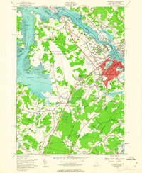
 1956 Newmarket1958 Print · USGSCoastal New Hampshire's river-fed mill towns and rail junctions are caught in detail during the mid-1950s. Genealogists and historians can trace family plots at Riverside Cem or locate the vital rail hub at Rockingham Junction and the small settlement of Littlefield.5 unique versions available
 - 1956 Map of Haverhill, 1959 Print
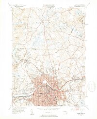
 1956 Haverhill1959 Print · USGSMid-century New England comes to life across the New Hampshire and Massachusetts border during this period of significant growth. Genealogists and historians can trace the Whittier Birthplace, numerous local schools like Tilton Sch, and the busy corridors of the Boston and Maine Railroad.3 unique versions available
 - 1956 Map of Dover, 1960 Print
 1956 Dover1960 Print · USGSCoastal New Hampshire and the Maine borderlands are captured here during a period of massive transition as modern infrastructure meets historic mill towns. Researchers can trace the development of Pease Air Force Base or locate family roots at Winnicut Mills and Packers Falls Cem.4 unique versions available
 - 1956 Map of York, 1960 Print
 1956 York1960 Print · USGSThe Maine coastline in the mid-fifties shows a world of historic harbor defenses and growing seaside resorts. Genealogists can trace family names at Brixham Upper Corners, locate the First Parish Ch, and explore the shoreline from York Cliffs to Kittery.4 unique versions available
 - 1956 Map of Portland, 1963 Print
 1956 Portland1963 Print · USGSSouthern Maine and eastern New Hampshire are captured here in the mid-fifties, during a time of major highway expansion and military growth. You can trace the path of the Maine Turnpike and locate landmarks like the Portsmouth Naval Shipyard and Sebago Lake.4 unique versions available
 - 1956 Map of Portsmouth, 1963 Print
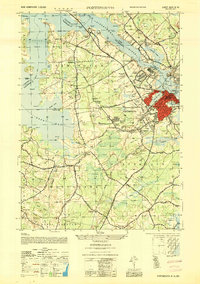
 1956 Portsmouth1963 Print · USGSCoastal New Hampshire and Maine are shown here during the mid-fifties, just as the massive Pease Air Force Base was established. Researchers can trace family sites from Winnicut Mills to Atlantic Heights and find local landmarks like Breakfast Hill.4 unique versions available
 - 1956 Map of Isles of Shoals, 1964 Print
 1956 Isles of Shoals1964 Print · USGSThe Isles of Shoals are captured here in the mid-1950s, detailing the maritime boundary between Maine and New Hampshire. Researchers can locate island landmarks such as Tucke Mon, the Lighthouse on White Island, and the settlement at Appledore.
 - 1956 Map of Boston, 1967 Print
 1956 Boston1967 Print · USGSThe Massachusetts coastline and industrial interior are seen here during the mid-century peak of suburban and highway expansion. Researchers can trace historic harbor defenses like Fort Revere, local landmarks such as Faneuil Hall, and the vast Parker River National Wildlife Refuge.6 unique versions available
 - 1957 Map of Mt. Pawtuckaway, 1959 Print
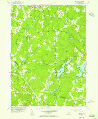
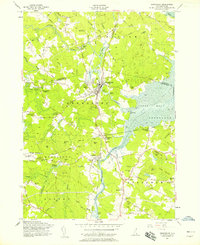
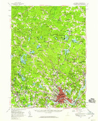
 1957 Mt. Pawtuckaway1959 Print · USGSRockingham and Strafford counties are shown in the late fifties, featuring a network of traditional villages and expanding recreational lakes. Researchers can trace historic sites like Nottingham Square, Deerfield Parade, and the Watson Academy.4 unique versions available
Showing maps 1-25 of 31
Top cities of Rockingham County
- Derry historical maps
- Salem historical maps
- Londonderry historical maps
- Portsmouth historical maps
- Hampton historical maps
- Windham historical maps
See more
Frequently asked questions
- What are the different types of historical maps available for Rockingham County?
- What is the oldest map of Rockingham County?
- Where can I purchase historical maps of Rockingham County for my home or office?
- Where can I download high-res historical maps of Rockingham County?
- Are there historical topographic maps available for Rockingham County?
- Is there historical aerial imagery available for Rockingham County?
- Where are historical maps of Rockingham County sourced from?