1980s Maps of Exeter, New Hampshire
Explore 10 historic maps of Exeter from the 1980s. These maps offer a rare glimpse into what life looked like during the 1980s — showing old roads, neighborhoods, homes, and landmarks that have changed or disappeared over time.
Whether you're researching your family's past, planning a metal detecting trip, or studying how Exeter's landscape evolved across the 1980s, these high-resolution maps are a powerful tool for exploring the history of this region.
- Focus on a specific era: All maps on this page are from the 1980s, giving you a focused view of this time period.
- See what’s changed: Compare century-old streets, trails, and buildings to today's modern landscape using overlays and satellite layers.
- Research with precision: Use these maps for genealogy, historical research, land use analysis, or educational projects.
- View, download, or print: Maps are fully viewable online in high resolution, and can be downloaded or printed for your own records.
Start exploring Exeter's history through authentic maps from the 1980s. This is your window into the past.
Exeter, NH maps
(10)- 1981 Map of Kingston
 1981 Kingston1981 Print · USGSSouthern New Hampshire's pond country is captured here in the early eighties, showing the historic village centers of Kingston and Brentwood. Genealogists can trace family sites at Ye Old Cem or Brentwood Cem and locate landmarks like the Ye Old Meeting House.2 unique versions available
 - 1981 Map of Epping
 1981 Epping1981 Print · USGSIn the early 1980s, the Rockingham County countryside remained a patchwork of small villages, historic river systems, and rail corridors. Researchers can trace ancestral plots and early civic life through Nottingham Square, the Ladd Cem, and the old Boston and Maine Railroad lines.
 - 1984 Map of Lowell
 1984 Lowell1984 Print · USGSThe Merrimack Valley industrial corridor is captured here in the mid-eighties, showing the interconnected growth of Lowell, Nashua, and Lawrence. Genealogists and historians can trace the paths of the Boston and Maine railroad or locate institutional landmarks like Merrimack College and the Fort Devens Military Reservation.
 - 1984 Map of Gloucester
 1984 Gloucester1984 Print · USGSCoastal Massachusetts and the New Hampshire borderlands are shown here in the mid-eighties, from the granite shores of Cape Ann to the Merrimack River. Researchers can trace the legacy of maritime trade and higher education at Salem State College or follow the Boston and Maine rail lines through Ipswich and Beverly.
 - 1985 Map of Exeter
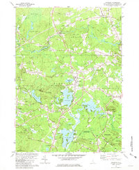
 1985 Exeter1985 Print · USGSThe New Hampshire seacoast in the mid-eighties shows a landscape of colonial roots meeting modern energy infrastructure. Genealogists and historians can trace long-standing family corners and sites like Phillips Exeter Academy or Coffins Mill alongside the emerging Seabrook nuclear facility.
 - 1985 Map of Kittery, 1986 Print
 1985 Kittery1986 Print · USGSThe Maine and New Hampshire borderlands are shown here in the mid-eighties, centered on the strategic Piscataqua River harbor. Genealogists and historians can trace the development of coastal towns like York or locate the sprawling Portsmouth Naval Shipyard and Pease Air Force Base.2 unique versions available
 - 1986 Map of Concord
 1986 Concord1986 Print · USGSCentral New Hampshire in the mid-eighties shows a landscape of river-valley cities and rural villages connected by the growing interstate system. Genealogists and historians can trace old community centers like Gilmanton Ironworks or follow the Boston and Maine Railroad through Concord and Tilton.
 - 1987 Map of Exeter
 1987 Exeter1987 Print · USGSThe Rockingham County coast and inland corridors are captured here in the late eighties, featuring the transition from Exeter to the Atlantic shore. Researchers can trace the development of the Seabrook Power Plant or locate local landmarks like Phillips Exeter Academy and Coffins Mill.
 - 1988 Map of Lowell
 1988 Lowell1988 Print · USGSThe industrial corridor of the Merrimack Valley is captured in the late eighties as it transitioned into a modern technological and residential hub. Genealogists and researchers can trace the urban layouts of Lowell and Nashua alongside landmarks like Massabesic Lake and Miller State Park.2 unique versions available
 - 1988 Map of Concord
 1988 Concord1988 Print · USGSCentral New Hampshire in the late eighties centers on the industrial and political hub of Concord. Researchers can trace the Boston and Maine RR along the Merrimack River or locate recreation landmarks like Bear Brook State Park and Massabesic Lake.
End of results
Showing maps 1-10 of 10
Top cities near Exeter
- Haverhill historical maps
- Methuen historical maps
- Dover historical maps
- Salem historical maps
- Portsmouth historical maps
- Newburyport historical maps
See more
Top neighborhoods of Exeter
- Perkins Hill historical maps
- Jady Hill historical maps
- Dows Corner historical maps
- West End historical maps
- The Plains historical maps
Frequently asked questions
- What are the different types of historical maps available for Exeter?
- What is the oldest map of Exeter?
- Where can I purchase historical maps of Exeter for my home or office?
- Where can I download high-res historical maps of Exeter?
- Are there historical topographic maps available for Exeter?
- Is there historical aerial imagery available for Exeter?
- Where are historical maps of Exeter sourced from?