1950s Maps of Sullivan County, New Hampshire
Explore 13 historic maps of Sullivan County from the 1950s. These maps offer a rare glimpse into what life looked like during the 1950s — showing old roads, neighborhoods, homes, and landmarks that have changed or disappeared over time.
Whether you're researching your family's past, planning a metal detecting trip, or studying how Sullivan County's landscape evolved across the 1950s, these high-resolution maps are a powerful tool for exploring the history of this region.
- Focus on a specific era: All maps on this page are from the 1950s, giving you a focused view of this time period.
- See what’s changed: Compare century-old streets, trails, and buildings to today's modern landscape using overlays and satellite layers.
- Research with precision: Use these maps for genealogy, historical research, land use analysis, or educational projects.
- View, download, or print: Maps are fully viewable online in high resolution, and can be downloaded or printed for your own records.
Start exploring Sullivan County's history through authentic maps from the 1950s. This is your window into the past.
Sullivan County, NH maps
(13)- 1950 Map of Glens Falls
 1950 Glens Falls1950 Print · USGSThe Adirondacks and the Green Mountains meet in this mid-century survey of the New York and Vermont borderlands. Researchers can trace the industrial rail corridors of the Rutland RR and Delaware & Hudson RR connecting Glens Falls, Rutland, and the shores of Lake George.
 - 1955 Map of Sunapee, 1957 Print
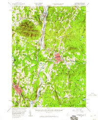
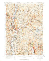
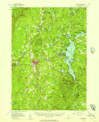 1955 Sunapee1957 Print · USGSSullivan County in the mid-fifties is captured here as a landscape of granite ridges, industrial valleys, and developing lakefronts. Genealogists and historians can locate the Little Red Schoolhouse Museum, the Wayside Chapel, and active rail lines like the Boston and Maine RR.3 unique versions available
 - 1956 Map of Cardigan, 1958 Print
 1956 Cardigan1958 Print · USGSGrafton County's high ridges and lake shores are captured here during the mid-fifties, showing the region's transition toward recreation and conservation. Genealogists and hikers can trace the Boston and Maine rail line through Grafton Center or locate old district sites like the Red Sch and Alexandria Mica Mine.3 unique versions available
 - 1956 Map of Mt. Kearsarge, 1959 Print
 1956 Mt. Kearsarge1959 Print · USGSMerrimack County’s upland terrain and valley settlements are captured in the mid-1950s, showing the height of the region’s rail-and-resort character. Researchers can trace the Boston & Maine RR line through Potter Place and locate historic markers like Colby Jr College and Lake Massasecum.4 unique versions available
 - 1956 Map of Portland, 1963 Print
 1956 Portland1963 Print · USGSSouthern Maine and eastern New Hampshire are captured here in the mid-fifties, during a time of major highway expansion and military growth. You can trace the path of the Maine Turnpike and locate landmarks like the Portsmouth Naval Shipyard and Sebago Lake.4 unique versions available
 - 1956 Map of Glens Falls, 1968 Print
 1956 Glens Falls1968 Print · USGSUpper New York and the Vermont mountains are captured here in the mid-fifties, showing the rugged rail-and-river network of the Northeast. Researchers can trace the paths of the Delaware and Hudson RR and Rutland RR as they wind through valley towns like Poultney and Whitehall.3 unique versions available
 - 1957 Map of Lovewell Mountain, 1959 Print
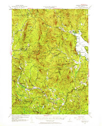
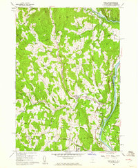
 1957 Lovewell Mountain1959 Print · USGSThe hill country of southwestern New Hampshire is captured here in the mid-1950s, showing the intersection of Sullivan, Cheshire, and Hillsborough counties. Researchers can trace old routes like the Dartmouth College Highway and locate rural landmarks such as Advent Ch, Mill Village, and East Lempster.4 unique versions available
 - 1957 Map of Claremont, 1960 Print
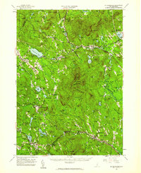
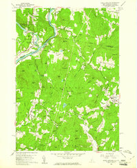
 1957 Claremont1960 Print · USGSThe Connecticut River valley thrives during the late fifties, showcasing a robust industrial landscape shaped by the Sugar and Black Rivers. Genealogists and local historians can trace family roots through riverside settlements like Weathersfield Bow, rural outposts like Quaker City, and landmarks such as the Cornish Bridge.3 unique versions available
 - 1957 Map of Bellows Falls, 1960 Print
 1957 Bellows Falls1960 Print · USGSThe Connecticut River valley and its border communities were defined by industry and rail at mid-century. Genealogists and historians can trace the paths of the Boston and Maine railroad, locate the Kurn Hattin Home, or find the historic Dodge Tavern.4 unique versions available
 - 1959 Map of Glens Falls
 1959 Glens Falls1959 Print · USGSUpper New York and Vermont are captured here during the late 1950s, a period of transition for these mountain communities. Researchers can trace the legacy of the region's river-and-rail economy through landmarks like Lake George, Saratoga Springs, and Killington Peak.2 unique versions available
 - 1959 Map of Portland
 1959 Portland1959 Print · USGSThe Maine and New Hampshire coastlines meet in this mid-century portrait of maritime commerce and inland rail networks. Researchers can trace the legacy of coastal defense at Fort Williams and follow the historic path of the Maine Central RR through the White Mountain National Forest.2 unique versions available
 - 1959 Map of Hartland, 1961 Print
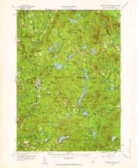
 1959 Hartland1961 Print · USGSThe Connecticut River valley south of White River Junction shows its mid-century character, from the State Prison Farm to the North Hartland Reservoir. Researchers can trace old family names at Quaker Village Cem and locate historic sites like Jenneville and the Covered Bridge.4 unique versions available
 - 1959 Map of North Hartland, 1961 Print
 1959 North Hartland1961 Print · USGSThe Upper Connecticut River Valley at the end of the 1950s shows a landscape of river-driven industry and academic tradition. Genealogists and historians can trace the foundations of Meriden, identify the location of the Kimball Union Academy, and locate dozens of family cemeteries such as Gallup Cem.4 unique versions available
End of results
Showing maps 1-13 of 13
Top cities of Sullivan County
- Claremont historical maps
- Newport historical maps
- Grantham historical maps
- Sunapee historical maps
- Plainfield historical maps
- Unity historical maps
See more
Frequently asked questions
- What are the different types of historical maps available for Sullivan County?
- What is the oldest map of Sullivan County?
- Where can I purchase historical maps of Sullivan County for my home or office?
- Where can I download high-res historical maps of Sullivan County?
- Are there historical topographic maps available for Sullivan County?
- Is there historical aerial imagery available for Sullivan County?
- Where are historical maps of Sullivan County sourced from?