1990s Maps of Claremont, New Hampshire
Explore 4 historic maps of Claremont from the 1990s. These maps offer a rare glimpse into what life looked like during the 1990s — showing old roads, neighborhoods, homes, and landmarks that have changed or disappeared over time.
Whether you're researching your family's past, planning a metal detecting trip, or studying how Claremont's landscape evolved across the 1990s, these high-resolution maps are a powerful tool for exploring the history of this region.
- Focus on a specific era: All maps on this page are from the 1990s, giving you a focused view of this time period.
- See what’s changed: Compare century-old streets, trails, and buildings to today's modern landscape using overlays and satellite layers.
- Research with precision: Use these maps for genealogy, historical research, land use analysis, or educational projects.
- View, download, or print: Maps are fully viewable online in high resolution, and can be downloaded or printed for your own records.
Start exploring Claremont's history through authentic maps from the 1990s. This is your window into the past.
Claremont, NH maps
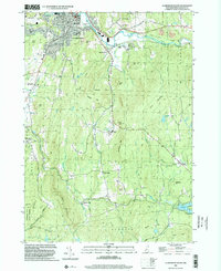
(4)- 1998 Map of Claremont North, 2002 Print
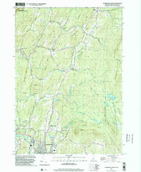 1998 Claremont North2002 Print · USGSSullivan County at the close of the twentieth century shows a landscape where historic preservation meets modern industry. Genealogists can trace family names at Edminster Cem and Cornings Cem, while historians can locate the Covered Bridge and the Saint Gaudens National Historic Site.
 - 1998 Map of Springfield, 2002 Print
 1998 Springfield2002 Print · USGSThe Connecticut River valley at the close of the twentieth century shows a region of industrial towns and conserved forests. Researchers can trace local genealogy and rail history through Eureka Cem, the Claremont & Concord RR, and Goulds Mill.
 - 1998 Map of Windsor, 2002 Print
 1998 Windsor2002 Print · USGSWindsor and the Connecticut River Valley are captured here in the late nineties, showing the region's transition between conserved highlands and riverfront industry. Trace local landmarks like the Cornish Bridge, the Central Vermont rail line, and the slopes of Mt Ascutney.
 - 1998 Map of Claremont South, 2002 Print
 1998 Claremont South2002 Print · USGSSullivan County upland life and industry converge in the late nineties, from the bustling streets of Claremont to the quiet heights of Unity Mountain. Researchers can trace historic hamlets like Quaker City and Puckershire or locate the Hubbard Cem and County Home.
End of results
Showing maps 1-4 of 4
Top cities near Claremont
- Lebanon historical maps
- Brockways Mills historical maps
- Newport historical maps
- Enfield historical maps
- Springfield historical maps
- Walpole historical maps
See more
Top neighborhoods of Claremont
- Puckershire historical maps
- West Claremont historical maps
- Lower Village District historical maps
- Central Business District Historic District historical maps
Frequently asked questions
- What are the different types of historical maps available for Claremont?
- What is the oldest map of Claremont?
- Where can I purchase historical maps of Claremont for my home or office?
- Where can I download high-res historical maps of Claremont?
- Are there historical topographic maps available for Claremont?
- Is there historical aerial imagery available for Claremont?
- Where are historical maps of Claremont sourced from?