1990s Maps of Sunapee, New Hampshire
Explore 4 historic maps of Sunapee from the 1990s. These maps offer a rare glimpse into what life looked like during the 1990s — showing old roads, neighborhoods, homes, and landmarks that have changed or disappeared over time.
Whether you're researching your family's past, planning a metal detecting trip, or studying how Sunapee's landscape evolved across the 1990s, these high-resolution maps are a powerful tool for exploring the history of this region.
- Focus on a specific era: All maps on this page are from the 1990s, giving you a focused view of this time period.
- See what’s changed: Compare century-old streets, trails, and buildings to today's modern landscape using overlays and satellite layers.
- Research with precision: Use these maps for genealogy, historical research, land use analysis, or educational projects.
- View, download, or print: Maps are fully viewable online in high resolution, and can be downloaded or printed for your own records.
Start exploring Sunapee's history through authentic maps from the 1990s. This is your window into the past.
Sunapee, NH maps
(4)- 1998 Map of Sunapee Lake North, 2002 Print
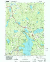 1998 Sunapee Lake North2002 Print · USGSSullivan County lake life and upland forests are on full display in this late-nineties survey. Local researchers can trace family lands near Georges Mills, locate the Eastman Cem, and study the early resort footprints at Soo Nipi Park and Granliden.
 - 1998 Map of Newport, 2002 Print
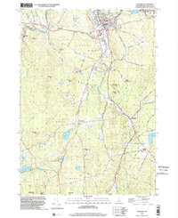 1998 Newport2002 Print · USGSSullivan County at the close of the twentieth century reveals a landscape shaped by the Sugar River and its industrial corridors. Researchers can trace the OLD RR GRADE through historic hamlets like Chandlers Mills and locate family names at Maple Street Cem.
 - 1998 Map of Grantham, 2002 Print
 1998 Grantham2002 Print · USGSSullivan County at the close of the twentieth century shows a landscape of river-valley hamlets and timbered ridges. Researchers can trace the Old Railroad Grade through Guild or locate old upland sites near Croydon Four Corners and Ryder Corner.
 - 1998 Map of Sunapee Lake South, 2002 Print
 1998 Sunapee Lake South2002 Print · USGSMerrimack and Sullivan Counties at the close of the twentieth century show a landscape defined by forest conservation and mountain tourism. Researchers can trace the Old Railroad Grade and locate historic points like Blodgett Landing or Sunapee Station.
End of results
Showing maps 1-4 of 4
Top cities near Sunapee
- Lebanon historical maps
- Claremont historical maps
- Hartford historical maps
- Newport historical maps
- Enfield historical maps
- New London historical maps
See more
Top neighborhoods of Sunapee
- Burkehaven historical maps
- Fernwood historical maps
- Granliden historical maps
- Georges Mills historical maps
- White Shutters historical maps
Frequently asked questions
- What are the different types of historical maps available for Sunapee?
- What is the oldest map of Sunapee?
- Where can I purchase historical maps of Sunapee for my home or office?
- Where can I download high-res historical maps of Sunapee?
- Are there historical topographic maps available for Sunapee?
- Is there historical aerial imagery available for Sunapee?
- Where are historical maps of Sunapee sourced from?