1950s Maps of Atlantic County, New Jersey
Explore 22 historic maps of Atlantic County from the 1950s. These maps offer a rare glimpse into what life looked like during the 1950s — showing old roads, neighborhoods, homes, and landmarks that have changed or disappeared over time.
Whether you're researching your family's past, planning a metal detecting trip, or studying how Atlantic County's landscape evolved across the 1950s, these high-resolution maps are a powerful tool for exploring the history of this region.
- Focus on a specific era: All maps on this page are from the 1950s, giving you a focused view of this time period.
- See what’s changed: Compare century-old streets, trails, and buildings to today's modern landscape using overlays and satellite layers.
- Research with precision: Use these maps for genealogy, historical research, land use analysis, or educational projects.
- View, download, or print: Maps are fully viewable online in high resolution, and can be downloaded or printed for your own records.
Start exploring Atlantic County's history through authentic maps from the 1950s. This is your window into the past.
Atlantic County, NJ maps
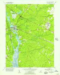
(22)- 1951 Map of New Gretna, 1954 Print
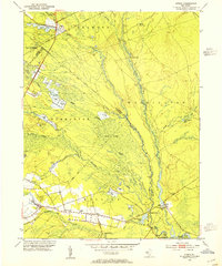
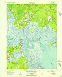 1951 New Gretna1954 Print · USGSThe coastal wetlands of Burlington and Atlantic counties are captured here in the early fifties, just as the Garden State Parkway was being built. Genealogists can trace family lines near New Gretna, Port Republic, and the Hillside Cem.7 unique versions available
 - 1952 Map of Brigantine Inlet, 1954 Print
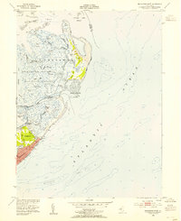 1952 Brigantine Inlet1954 Print · USGSCoastal New Jersey is captured in the early fifties during a pivotal era of shoreline development and conservation. Genealogists and local historians can trace the early streets of Brigantine, find the 14th Street Pier, and explore the marshes of the Brigantine National Wildlife Refuge.4 unique versions available
 - 1952 Map of Tuckerton, 1954 Print
 1952 Tuckerton1954 Print · USGSCoastal New Jersey in the early fifties reveals a landscape of tidal marshes and quiet seaside boroughs before the era of major development. Researchers can trace family roots through Greenwood Cem or locate industrial sites like the Fish Factory and Cranberry Bogs.6 unique versions available
 - 1952 Map of Atlantic City, 1955 Print
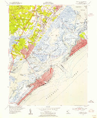
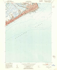 1952 Atlantic City1955 Print · USGSAtlantic City and the Jersey Shore are captured here in the early fifties, documenting the iconic resort at its mid-century height. Trace the original footprints of the Boardwalk piers, the Bader Field airport, and the Pennsylvania-Reading Seashore Lines.4 unique versions available
 - 1952 Map of Marmora, 1955 Print
 1952 Marmora1955 Print · USGSCoastal New Jersey during the early fifties reveals a landscape of tidal marshes and riverside landings at the confluence of two major rivers. Genealogists and local historians can trace family-named sites like Jeffers Landing, Scullville, and Palestine Ch along the winding banks of the Great Egg Harbor River.4 unique versions available
 - 1952 Map of Ocean City, 1955 Print
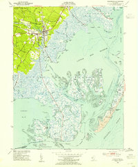
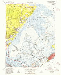
 1952 Ocean City1955 Print · USGSThe Jersey Shore's barrier islands and mainland communities come alive in the early fifties, showing the interplay of coastal development and tidal marshland. Trace the rail routes of the Pennsylvania-Reading Seashore Lines or locate landmarks like the Municipal Pier and Friends Central Cem.4 unique versions available
 - 1952 Map of Oceanville, 1955 Print
 1952 Oceanville1955 Print · USGSThe Atlantic County shoreline in the early fifties reveals a landscape of tidal marshes and growing coastal towns. Genealogists and historians can trace family-named routes like Leeds Point Road or locate landmarks such as the Seaview Country Club and Lily Lake.3 unique versions available
 - 1952 Map of Pleasantville, 1955 Print
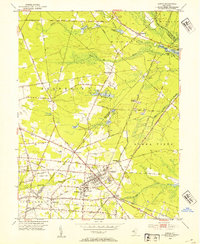
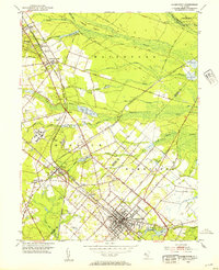
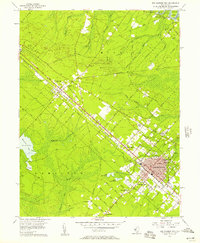
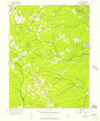
 1952 Pleasantville1955 Print · USGSAtlantic County at the dawn of the 1950s reveals a landscape of growing coastal suburbs and significant military aviation. Genealogists and local historians can trace the foundations of Pleasantville and find family landmarks like Sholem Cemetery, the Atlantic City Speedway, and Bargaintown.3 unique versions available
 - 1953 Map of Atsion, 1954 Print
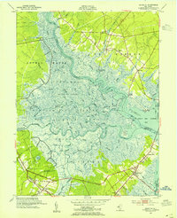
 1953 Atsion1954 Print · USGSThe New Jersey Pine Barrens in the early fifties reveal a landscape shaped by water and iron history. Trace the legacy of early settlements and agriculture through the Central Railroad of New Jersey, the sprawling Cranberry Bogs, and historic river crossings at Quaker Bridge.6 unique versions available
 - 1953 Map of Buena, 1954 Print
 1953 Buena1954 Print · USGSIn the early fifties, South Jersey was a patchwork of small truck farms and rural crossroads centered around Landisville and Minotola. Trace local history through landmarks like St Marys Cemetery, the Downstown Airfield, and Folsom.4 unique versions available
 - 1953 Map of Hammonton, 1954 Print
 1953 Hammonton1954 Print · USGSThe Hammonton area in the early fifties shows the New Jersey Pinelands as a vital hub of rail commerce and cranberry cultivation. Genealogists and historians can trace family locations through sites like Bates Mill Cem, Chesilhurst Sta, and Winslow Junction.2 unique versions available
 - 1953 Map of Newtonville, 1954 Print
 1953 Newtonville1954 Print · USGSThe Pine Barrens of Atlantic County are captured here in the early fifties, showing the vital rail and road links of a rural agricultural landscape. Genealogists can locate family landmarks such as St James Ch and trace the small settlements of Newtonville and Da Costa.5 unique versions available
 - 1955 Map of Wilmington
 1955 Wilmington1955 Print · USGSThe Delaware Valley and Jersey Shore are seen here during the mid-fifties era of rapid suburban expansion and highway development. You can trace the path of the New Jersey Turnpike, locate the Fort Dix Military Reservation, or explore the rail networks of the Pennsylvania Railroad.
 - 1955 Map of Mays Landing, 1956 Print
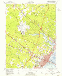
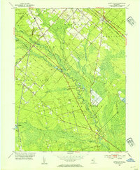
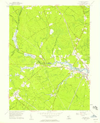
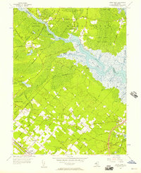
 1955 Mays Landing1956 Print · USGSAtlantic County at the midpoint of the century shows a landscape defined by the Great Egg Harbor River and its rail connections. Genealogists can trace family roots through Union Cem and small settlements like Catawba, Belcoville, and Estell Manor.3 unique versions available
 - 1956 Map of Egg Harbor City, 1957 Print
 1956 Egg Harbor City1957 Print · USGSAtlantic County during the mid-fifties shows a fascinating transition between the developed grids of Egg Harbor City and the surrounding pine barrens. Genealogists and historians can trace family locations near St Nicholas Ch, Laurel Hill Cem, and the old Amotol Race Track.6 unique versions available
 - 1956 Map of Tuckahoe, 1957 Print
 1956 Tuckahoe1957 Print · USGSThe coastal plains and river valleys of Cape May and Atlantic counties are captured here in the mid-fifties. Researchers can trace the legacy of family settlements and rural life at Steelmantown, Marshallville, and the Pennsylvania-Reading Seashore Lines.5 unique versions available
 - 1956 Map of Jenkins, 1957 Print
 1956 Jenkins1957 Print · USGSThe New Jersey Pine Barrens are captured here in the mid-1950s, showing a landscape of bog agriculture and isolated settlements. Trace family roots and local history through St Andrews Ch and remote outposts like Harrisville or Washington Ruin.3 unique versions available
 - 1956 Map of Dorothy, 1957 Print
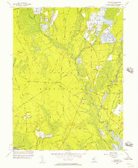
 1956 Dorothy1957 Print · USGSThe Pine Barrens of Atlantic County are captured here in the mid-fifties, showing the transition from grid-patterned towns to dense riverfront woodlands. Genealogists can trace family roots through Community Ch Cem, while historians can locate old industrial sites like Walkers Forge and the depot at Estell Manor (Risley Sta).4 unique versions available
 - 1956 Map of Green Bank, 1957 Print
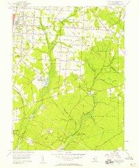
 1956 Green Bank1957 Print · USGSCoastal New Jersey in the mid-1950s reveals a unique blend of planned settlements and preserved wilderness along the Mullica River. Researchers can trace early family sites at Clarks Mill Burying Ground or explore the rail network of the Pennsylvania-Reading Seashore Lines.4 unique versions available
 - 1956 Map of Five Points, 1958 Print
 1956 Five Points1958 Print · USGSCumberland County communities appear in the mid-fifties during a period of agricultural and institutional growth. Genealogists and local historians can trace the foundations of the Manantico Colony, locate St Marys Ch, or find the mill sites at Leamings Mill.3 unique versions available
 - 1957 Map of Wilmington
 1957 Wilmington1957 Print · USGSThe mid-Atlantic coastal plain comes alive in the mid-fifties as the New Jersey Turnpike and Garden State Parkway redefine travel. Researchers can trace the rail-to-road transition and find landmarks like Ship John Shoal Light and the Fort Dix Military Reservation.2 unique versions available
 - 1959 Map of Wilmington
 1959 Wilmington1959 Print · USGSThe Delaware Valley and Jersey Shore are seen here in the late fifties, during a period of massive suburban and highway expansion. Researchers can trace mid-century infrastructure like the N J Turnpike or locate coastal landmarks from Barnegat Bay to the Maurice River.3 unique versions available
End of results
Showing maps 1-22 of 22
Top cities of Atlantic County
- Egg Harbor Township historical maps
- Atlantic City historical maps
- Galloway Township historical maps
- Hammonton historical maps
- Hamilton Township historical maps
- Pleasantville historical maps
See more
Frequently asked questions
- What are the different types of historical maps available for Atlantic County?
- What is the oldest map of Atlantic County?
- Where can I purchase historical maps of Atlantic County for my home or office?
- Where can I download high-res historical maps of Atlantic County?
- Are there historical topographic maps available for Atlantic County?
- Is there historical aerial imagery available for Atlantic County?
- Where are historical maps of Atlantic County sourced from?