1980s Maps of Atlantic County, New Jersey
Explore 9 historic maps of Atlantic County from the 1980s. These maps offer a rare glimpse into what life looked like during the 1980s — showing old roads, neighborhoods, homes, and landmarks that have changed or disappeared over time.
Whether you're researching your family's past, planning a metal detecting trip, or studying how Atlantic County's landscape evolved across the 1980s, these high-resolution maps are a powerful tool for exploring the history of this region.
- Focus on a specific era: All maps on this page are from the 1980s, giving you a focused view of this time period.
- See what’s changed: Compare century-old streets, trails, and buildings to today's modern landscape using overlays and satellite layers.
- Research with precision: Use these maps for genealogy, historical research, land use analysis, or educational projects.
- View, download, or print: Maps are fully viewable online in high resolution, and can be downloaded or printed for your own records.
Start exploring Atlantic County's history through authentic maps from the 1980s. This is your window into the past.
Atlantic County, NJ maps
(9)- 1984 Map of Atlantic City, 1985 Print
 1984 Atlantic City1985 Print · USGSThe Jersey Shore and Pine Barrens are captured here in the mid-eighties, showing the coastal transition from salt marsh to forest. Genealogists and historians can trace family locations from Estell Manor to North Wildwood or explore the vast bounds of the Belleplain State Forest.
 - 1984 Map of Hammonton, 1986 Print
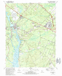
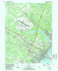
 1984 Hammonton1986 Print · USGSSouthern New Jersey is captured in the mid-eighties as suburban growth pressed against the vast Pinelands. Researchers can trace the development of the Atlantic City Expressway corridor and locate landmarks like Ancora Psychiatric Hospital and the sprawling Wharton State Forest.3 unique versions available
 - 1989 Map of Mays Landing
 1989 Mays Landing1989 Print · USGSMays Landing and the Great Egg Harbor River valley are captured here in the late eighties as the region balanced its rural roots with modern infrastructure. Genealogists and local historians can trace family sites at Union Cem, explore the sprawling Atlantic City Racetrack, or follow the Old Railroad Grade.
 - 1989 Map of Ocean City
 1989 Ocean City1989 Print · USGSThe New Jersey shoreline in the late eighties reveals the established resort grids of Ocean City alongside the growing mainland suburbs. Genealogists and historians can trace the development of Somers Point and locate landmarks like Friends Central Cem and the City Hall Museum.
 - 1989 Map of Marmora
 1989 Marmora1989 Print · USGSThe coastal marshes of Atlantic and Cape May counties are captured here in the late eighties as the region balanced conservation with growth. Genealogists and local historians can locate several rural landmarks including Asbury Ch, Seaside Cem, and the historic settlement at Beesleys Point.2 unique versions available
 - 1989 Map of Oceanville
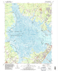
 1989 Oceanville1989 Print · USGSCoastal New Jersey in the late eighties reveals a landscape where modern highways intersect with ancient salt marshes and tidal thoroughfares. Researchers can trace local development around Smithville, the aviation history of the Smithville Airport, and landmarks like Mainland Ch.
 - 1989 Map of Pleasantville
 1989 Pleasantville1989 Print · USGSCoastal New Jersey during the late eighties shows a landscape of rapid suburban growth and major aviation hubs inland from the shore. Genealogists and researchers can locate old burial grounds like Beth-Kehillah Cem or trace the early footprint of Stockton State College.
 - 1989 Map of Brigantine Inlet
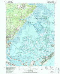
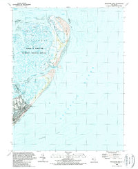 1989 Brigantine Inlet1989 Print · USGSCoastal New Jersey at the end of the eighties reveals a landscape of protected wetlands and expanding beach communities. Trace the shoreline from the 14th Street Pier up to the wild reaches of Little Beach and the Edwin B Forsythe National Wildlife Refuge.
 - 1989 Map of Atlantic City
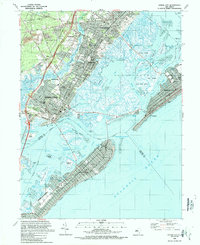
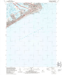 1989 Atlantic City1989 Print · USGSAtlantic City and its neighboring shore communities are captured in the late eighties as a bustling coastal hub of gaming and tourism. Genealogists and historians can trace the developed waterfront from Steel Pier down to the Boardwalk and the neighborhood of Chelsea Heights.2 unique versions available
End of results
Showing maps 1-9 of 9
Top cities of Atlantic County
- Egg Harbor Township historical maps
- Atlantic City historical maps
- Galloway Township historical maps
- Hammonton historical maps
- Hamilton Township historical maps
- Pleasantville historical maps
See more
Frequently asked questions
- What are the different types of historical maps available for Atlantic County?
- What is the oldest map of Atlantic County?
- Where can I purchase historical maps of Atlantic County for my home or office?
- Where can I download high-res historical maps of Atlantic County?
- Are there historical topographic maps available for Atlantic County?
- Is there historical aerial imagery available for Atlantic County?
- Where are historical maps of Atlantic County sourced from?