1990s Maps of Atlantic County, New Jersey
Explore 14 historic maps of Atlantic County from the 1990s. These maps offer a rare glimpse into what life looked like during the 1990s — showing old roads, neighborhoods, homes, and landmarks that have changed or disappeared over time.
Whether you're researching your family's past, planning a metal detecting trip, or studying how Atlantic County's landscape evolved across the 1990s, these high-resolution maps are a powerful tool for exploring the history of this region.
- Focus on a specific era: All maps on this page are from the 1990s, giving you a focused view of this time period.
- See what’s changed: Compare century-old streets, trails, and buildings to today's modern landscape using overlays and satellite layers.
- Research with precision: Use these maps for genealogy, historical research, land use analysis, or educational projects.
- View, download, or print: Maps are fully viewable online in high resolution, and can be downloaded or printed for your own records.
Start exploring Atlantic County's history through authentic maps from the 1990s. This is your window into the past.
Atlantic County, NJ maps
(14)- 1994 Map of Five Points, 1998 Print
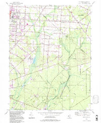 1994 Five Points1998 Print · USGSCumberland County during the late twentieth century reveals a landscape shaped by institutional growth and extensive pine barrens. Genealogists and historians can locate Vineland State School, trace the Central Railroad of New Jersey, and find old centers like New Italy.
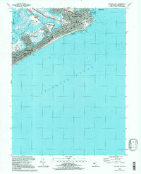
 - 1994 Map of Brigantine Inlet, 1998 Print
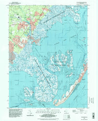
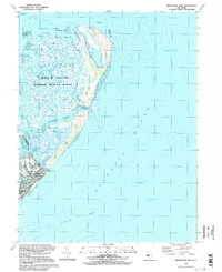 1994 Brigantine Inlet1998 Print · USGSCoastal New Jersey is captured in the late twentieth century as the barrier island town of Brigantine meets the protected salt marshes. Trace the residential growth near Brigantine North Sch or explore the inlets and thorofares of the Edwin B Forsythe National Wildlife Refuge.
 - 1994 Map of Atlantic City, 1998 Print
 1994 Atlantic City1998 Print · USGSThe Jersey Shore's premier resort city appears in the mid-nineties, showing the dense grid from Absecon Inlet down to Margate City. Trace the famous Boardwalk and its piers, or locate landmarks like Bader Field and the Convention Hall.
 - 1994 Map of Tuckahoe, 1998 Print
 1994 Tuckahoe1998 Print · USGSSouthern New Jersey in the 1990s reveals a landscape defined by the Tuckahoe River and vast state conservation lands. Genealogists and historians can trace old community ties through locations like Steelmantown, Marshallville, and the remote Hunters Mill.
 - 1994 Map of Marmora, 1998 Print
 1994 Marmora1998 Print · USGSThe intersection of the Atlantic and Cape May county lines comes alive in the mid-1990s through this detailed survey of the Great Egg Harbor wetlands. Researchers can trace family-named sites like Scullville and Beesleys Point or locate Asbury Ch and Seaside Cem.2 unique versions available
 - 1994 Map of Pleasantville, 1998 Print
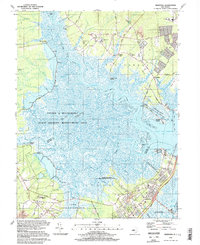
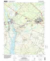
 1994 Pleasantville1998 Print · USGSCoastal Atlantic County comes into focus in the mid-1990s as suburban development surrounds established hubs like Pleasantville and Northfield. Researchers can trace local lineage through numerous sites like Beth-Kehillah Cem or locate the sprawling Stockton State College campus.
 - 1994 Map of Ocean City, 1998 Print
 1994 Ocean City1998 Print · USGSCoastal New Jersey comes alive in the mid-nineties as suburban growth meets the complex estuaries of the Atlantic shore. Genealogists and local historians can trace the streets of Ocean City, find the Friends Central Cem, or locate the historic Zion Ch and Bargaintown.
 - 1994 Map of Dorothy, 1998 Print
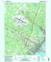
 1994 Dorothy1998 Print · USGSAtlantic County at the end of the twentieth century remains a landscape of forest preserves and small crossroads towns. Genealogists and local historians can trace the foundations of Dorothy, Gigantic City, and Milmay, or locate family landmarks like Estell Manor Sch and St James Ch.
 - 1995 Map of Tuckerton, 1998 Print
 1995 Tuckerton1998 Print · USGSThe Jersey Shore's tidal marshes and barrier islands come into focus during the mid-nineties, showing the mainland growth of Tuckerton and Giffordtown. Genealogists and local historians can trace legacy sites like Greenwood Cem, the Township Sch, and the maritime infrastructure of Parkers Landing.
 - 1995 Map of Oceanville, 2000 Print
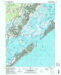
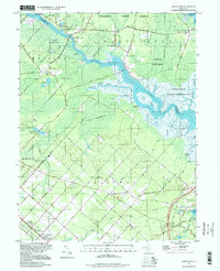
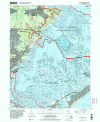 1995 Oceanville2000 Print · USGSCoastal Atlantic County comes into focus in the mid-1990s, showcasing the intricate balance between suburban expansion and protected marshlands. Researchers can trace the layout of historic communities like Smithville and Oceanville or locate landmarks such as the Seaview Country Club and the Coast Guard Station.
 - 1995 Map of Mays Landing, 2000 Print
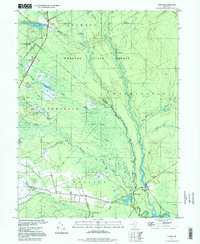
 1995 Mays Landing2000 Print · USGSAtlantic County’s riverfront settlements and Pine Barrens fringes are captured here in the mid-1990s as modern infrastructure met historic landings. Trace family roots and local development near Mays Landing, Steelman Landing, and the Lakewood Chapel.
 - 1997 Map of Jenkins, 1998 Print
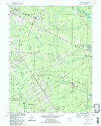
 1997 Jenkins1998 Print · USGSThe New Jersey Pine Barrens are captured here in the late twentieth century, showing a landscape defined by cranberry culture and old forest ruins. Genealogists and local historians can trace family-named sites like Bulltown and Crowleytown or locate the Washington Ruin and St Andrews Ch.
 - 1997 Map of Green Bank, 1998 Print
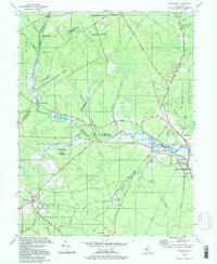
 1997 Green Bank1998 Print · USGSThe Mullica River valley and the German-influenced streets of Egg Harbor City are captured here in the late nineties. Local researchers can trace family landmarks like Clarks Mill Burying Ground, Snyder Sch, and the riverside sites of Lower Bank and Clarks Landing.
 - 1997 Map of Atsion, 1998 Print
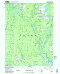
 1997 Atsion1998 Print · USGSThe New Jersey Pine Barrens are captured here in the late nineties, showing a landscape defined by the Mullica River and legacy cranberry production. Genealogists and historians can trace old community centers at Batsto and Pleasant Mills or locate the Nesco Sch and numerous Cranberry Bogs tucked into the Great Swamp.
End of results
Showing maps 1-14 of 14
Top cities of Atlantic County
- Egg Harbor Township historical maps
- Atlantic City historical maps
- Galloway Township historical maps
- Hammonton historical maps
- Hamilton Township historical maps
- Pleasantville historical maps
See more
Frequently asked questions
- What are the different types of historical maps available for Atlantic County?
- What is the oldest map of Atlantic County?
- Where can I purchase historical maps of Atlantic County for my home or office?
- Where can I download high-res historical maps of Atlantic County?
- Are there historical topographic maps available for Atlantic County?
- Is there historical aerial imagery available for Atlantic County?
- Where are historical maps of Atlantic County sourced from?