Old Maps of Bergen County, New Jersey for Academic Research
Study the evolution of Bergen County with 167 high-resolution historic maps. Whether you're teaching, researching, or modeling changes in land use, these maps provide essential visual documentation of urban, environmental, and geographic change.
- Analyze long-term change: Track patterns in development, transportation, and natural features.
- Ideal for environmental or urban studies: Support academic projects with primary historical map data.
- Use in the classroom or lab: Educators and researchers rely on these maps to bring historical context to life.
These maps are a powerful tool for teaching, research, and visualizing how Bergen County has changed over the decades.
Bergen County, NJ maps
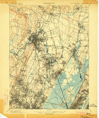
(167)- 1888 Map of Morristown
 1888 Morristown1888 Print · USGSNorthern New Jersey's transition from an industrial mining hub to a rail-connected suburb is evident in the late 1880s. Genealogists and historians can locate the Hibernia Mine, trace the Morris Canal Feeder, and find old river crossings like Columbia Bridge.
 - 1888 Map of Paterson
 1888 Paterson1888 Print · USGSNortheastern New Jersey in the late nineteenth century was a complex network of industrial canals and rising commuter towns. Genealogists and historians can trace the Morris Canal, the Jersey City Waterworks, and early rail lines through Hackensack and Paterson.
 - 1891 Map of Greenwood Lake
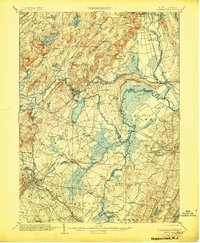
 1891 Greenwood Lake1891 Print · USGSThe Highlands of New York and New Jersey are captured here in the late nineteenth century during a peak era of iron mining and rail expansion. Researchers can trace the industrial footprint of the Sterling Furnace, locate family-named mines like Carey Mine, and follow the historic routes of the New York Susquehanna and Western Railroad.
 - 1891 Map of Ramapo
 1891 Ramapo1891 Print · USGSThe Ramapo Mountains and northern New Jersey borderlands appear here in the decade before the turn of the century. Genealogists and local historians can trace the early rail networks through Sloatsburg and Suffern, or locate family sites in Pearl River and Ramseys.
 - 1891 Map of Harlem
 1891 Harlem1891 Print · USGSUpper Manhattan and the Bronx met the burgeoning towns of Westchester and Bergen County in the late 1800s. Researchers can trace the path of the Croton Aqueduct, locate the historic site of Bulls Ferry, and explore the early rail-connected villages of Schraalenburgh and Pelhamville.
 - 1892 Map of Paterson
 1892 Paterson1892 Print · USGSNorthern New Jersey and the industrial core of Paterson are seen here in the late nineteenth century as rail and water infrastructure expanded. Trace the development of early utility systems like the Jersey City Waterworks or explore the rail lines of the Lodi Branch R.R. and West Shore Railroad.
 - 1892 Map of Tarrytown
 1892 Tarrytown1892 Print · USGSThe Hudson River valley in the late nineteenth century was a corridor of engineering and industrial growth. Researchers can trace the path of the Croton Aqueduct, locate the State Prison at Sing Sing, or find family names near Merritts Corners and Samsondale.
 - 1893 Map of Greenwood Lake
 1893 Greenwood Lake1893 Print · USGSThe iron-rich highlands of the New York-New Jersey border come to life in this late-century survey of the lakes and ridges between Passaic and Orange counties. Genealogists and industrial historians can trace the paths of the Sterling Mountain Railroad and find long-established sites like Sterling Furnace or the Layton Mines.6 unique versions available
 - 1893 Map of Tarrytown
 1893 Tarrytown1893 Print · USGSThe Hudson Valley was a powerhouse of transit and utility in the late 1800s, serving as the corridor for New York’s water and rail networks. Genealogists can trace family names and old landings from Haverstraw to Tarrytown, including features like the State Prison and the massive Croton Dam.3 unique versions available
 - 1893 Map of Ramapo
 1893 Ramapo1893 Print · USGSThe Ramapo Valley and the New Jersey borderlands come alive in the late Victorian era, showing a landscape defined by mountain passes and a dense rail network. Genealogists can trace family names and early homesteads in Johnsontown, Eagle Valley, and Pearl River before modern development changed the region.6 unique versions available
 - 1894 Map of Morristown
 1894 Morristown1894 Print · USGSNorthern New Jersey was a landscape of iron and water in the late nineteenth century, as the canal era gave way to steam power. Trace the winding Morris Canal, the mining works at Hibernia, and historic river crossings like Horse Neck Bridge.
 - 1897 Map of Harlem, 1956 Print
 1897 Harlem1956 Print · USGSUpper Manhattan and Westchester thrive at the end of the nineteenth century as rail lines and reservoirs reshape the landscape. Trace early neighborhoods and landmarks like Schraalenburg, Woodlawn Cemetery, and the Jerome Park Reservoir.4 unique versions available
 - 1898 Map of Harlem
 1898 Harlem1898 Print · USGSThe northern reaches of the city and its surrounding suburbs are shown in late-Victorian detail as rail lines expanded across the Hudson. Researchers can trace the early layouts of Woodlawn Cemetery, the site of Grants Tomb, and the fortifications at Fort Schuyler.
 - 1898 Map of Morristown
 1898 Morristown1898 Print · USGSMorris and Essex counties at the turn of the century show a complex landscape of early industrial rail lines and historic water routes. Researchers can trace the path of the Morris Canal and find vanished local landmarks like Malapardis, Beach Glen, and Swinefield Bridge.2 unique versions available
 - 1898 Map of Paterson
 1898 Paterson1898 Print · USGSNorthern New Jersey's industrial and rail corridors are captured here in the late nineteenth century, from the silk mills of Paterson to the Hackensack marshes. Genealogists can locate family sites near Laurel Grove Cemetery, the Morris Canal, and early villages like Wortendyke.
 - 1900 Map of Passaic
 1900 Passaic1900 Print · USGSNorthern New Jersey and the New York Harbor are captured here at the close of the nineteenth century, showing a landscape defined by rail, river, and coastal defense. Researchers can trace the original path of the Morris Canal, locate Seton Hall College, and explore the batteries at Fort Wadsworth.
 - 1900 Map of Paterson
 1900 Paterson1900 Print · USGSNortheastern New Jersey at the turn of the century shows a landscape defined by the Morris Canal and a dense network of early railroads. Researchers can trace ancestral roots through vanished rail stops and sites like Laurel Grove Cemetery, Wortendyke, and Sicomac.
 - 1900 Map of Harlem
 1900 Harlem1900 Print · USGSUpper Manhattan and the surrounding boroughs are shown at a pivotal moment of growth before the mid-century building boom. Genealogists can trace family footprints through the streets of Yonkers Park or locate ancestors in the sprawling Woodlawn Cemetery.16 unique versions available
 - 1902 Map of Tarrytown
 1902 Tarrytown1902 Print · USGSThe Hudson River valley at the turn of the century shows a landscape of busy river landings and nascent suburbs. Genealogists and historians can trace old homesteads and landmarks like Waldberg Landing, the State Prison at Ossining, and the Croton Aqueduct.11 unique versions available
 - 1903 Map of Paterson
 1903 Paterson1903 Print · USGSNorthern New Jersey's transition from an industrial river valley to a dense rail-connected region is captured here just after the turn of the century. You can trace the path of the Morris Canal, locate the old Dundee Dam, or find early settlements like Peetzburg and Etna.8 unique versions available
 - 1903 Map of Greenwood Lake, 1909 Print
 1903 Greenwood Lake1909 Print · USGSThe Highlands of New York and New Jersey are captured here at the height of their industrial era, showing a landscape of iron mines and mountain railroads. Genealogists and historians can locate heritage sites like Sterling Furnace, Dayton Mines, and the rural community of New Newfoundland.
 - 1905 Map of Passaic
 1905 Passaic1905 Print · USGSNorthern New Jersey and Staten Island appear here at a pivotal moment of early 20th-century growth and industrialization. Researchers can trace the development of transit hubs like Convent Sta. or locate legacy landmarks including Hillside Cemetery and the Moravian Cemetery.4 unique versions available
 - 1906 Map of Morristown
 1906 Morristown1906 Print · USGSNorthern New Jersey's transition from industrial highlands to riverine lowlands is captured here just after the turn of the century. Genealogists can trace family roots in Hibernia or Boonton and locate historic crossings like Columbia Bridge and the Morris Canal.6 unique versions available
 - 1910 Map of Ramapo
 1910 Ramapo1910 Print · USGSThe Ramapo Valley at the turn of the century served as a vital transit corridor between New York and New Jersey, dominated by rail lines and river industry. Genealogists and local historians can trace the foundations of Sloatsburg, Suffern, and Pearl River, alongside landmarks like the Ramapo Cem. and the Powder Works.6 unique versions available
 - 1910 Map of Greenwood Lake
 1910 Greenwood Lake1910 Print · USGSThe Highlands of northern New Jersey and southern New York are shown here during a peak era of iron mining and rail expansion. Genealogists and industrial historians can trace the foundations of Sterling Furnace, Charlotteburg Mine, and the New Milford Sta. along the Erie Railroad.9 unique versions available
Showing maps 1-25 of 167
Top cities of Bergen County
- Hackensack historical maps
- Teaneck Township historical maps
- Fort Lee historical maps
- Fair Lawn historical maps
- Garfield historical maps
- Englewood historical maps
See more
Frequently asked questions
- What are the different types of historical maps available for Bergen County?
- What is the oldest map of Bergen County?
- Where can I purchase historical maps of Bergen County for my home or office?
- Where can I download high-res historical maps of Bergen County?
- Are there historical topographic maps available for Bergen County?
- Is there historical aerial imagery available for Bergen County?
- Where are historical maps of Bergen County sourced from?