1900s (20th Century) Maps of Burlington County, New Jersey
Explore 108 historic maps of Burlington County from the 1900s (20th Century). These maps offer a rare glimpse into what life looked like during the 1900s — showing old roads, neighborhoods, homes, and landmarks that have changed or disappeared over time.
Whether you're researching your family's past, planning a metal detecting trip, or studying how Burlington County's landscape evolved across the 1900s, these high-resolution maps are a powerful tool for exploring the history of this region.
- Focus on a specific era: All maps on this page are from the 1900s, giving you a focused view of this time period.
- See what’s changed: Compare century-old streets, trails, and buildings to today's modern landscape using overlays and satellite layers.
- Research with precision: Use these maps for genealogy, historical research, land use analysis, or educational projects.
- View, download, or print: Maps are fully viewable online in high resolution, and can be downloaded or printed for your own records.
Start exploring Burlington County's history through authentic maps from the 1900s. This is your window into the past.
Burlington County, NJ maps
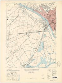
(108)- 1900 Map of Rancocas
 1900 Rancocas1900 Print · USGSSouthern New Jersey at the turn of the century reveals a land of timber, mills, and emerging rail junctions. Genealogists and historians can trace the locations of family-owned landmarks like Jennings Mill, Ballingers Mill, and early settlements such as Colemantown and Fellowship.2 unique versions available
 - 1901 Map of Camden
 1901 Camden1901 Print · USGSThe Delaware River valley at the turn of the century shows a bustling corridor of early industrial growth and established mill towns. Researchers can trace the heritage of local industry at Sycamore Mills or locate early settlements like Penns Grove and Village Green.3 unique versions available
 - 1904 Map of Burlington, 1958 Print
 1904 Burlington1958 Print · USGSThe Delaware River corridor thrives during the early twentieth century as a hub of rail, canal, and river commerce. Genealogists and local historians can trace family roots through riverside landings like Borton Landing or follow the legacy of institutions such as the George School and the State Lunatic Asylum.
 - 1906 Map of Burlington
 1906 Burlington1906 Print · USGSThe Delaware River corridor was a bustling hub of rail and water transport in the early 1900s. Genealogists and local historians can trace the development of riverside wharves like Andalusia Wharf and institutional landmarks such as the State Lunatic Asylum.6 unique versions available
 - 1906 Map of Bordentown
 1906 Bordentown1906 Print · USGSThe Delaware River corridor and Burlington County interior are seen here in the early 1900s, showing a landscape shaped by rail and river commerce. Genealogists can trace early homesteads and hamlets near Bordentown, Hamilton Square, and the mills at Walnford.6 unique versions available
 - 1907 Map of Trenton
 1907 Trenton1907 Print · USGSThe Delaware River valley hums with turn-of-the-century industry and transport as river canals and railroads converge between New Jersey and Pennsylvania. Genealogists and local historians can trace the footprint of the George School, find early post offices like Holland PO, or locate old mill sites such as Blackwells Mills.4 unique versions available
 - 1918 Map of Camp Dix
 1918 Camp Dix1918 Print · USGSNew Jersey at the height of the Great War features the sprawling mobilization grounds of Camp Dix and its expansive Rifle Range. Genealogists and historians can trace defunct stops like Imlaystown Sta or locate family roots near New Egypt and Colliers Mill.2 unique versions available
 - 1919 Map of Hammonton
 1919 Hammonton1919 Print · USGSThe Pine Barrens of the early twentieth century are defined here by a massive web of competing railroads and small mill settlements. Researchers can trace historic family landmarks and transit hubs like Winslow Junction, Iron Mills, and Pestletown during the region's peak agricultural era.
 - 1919 Map of Mount Holly, 1921 Print
 1919 Mount Holly1921 Print · USGSThe Burlington and Camden County interior appears here at a peak of rail-driven commerce during the early twentieth century. Genealogists and historians can trace family-named industrial sites like Kirby's Mill and old bog operations at the West Jersey Cranberry Meadow.
 - 1919 Map of Mullica, 1921 Print
 1919 Mullica1921 Print · USGSCoastal New Jersey's Pine Barrens and river landings are captured here in the early 1900s during a period of transition between water-based commerce and expanding rail lines. Researchers can trace the legacy of iron and agriculture through sites like Batsto, Harris Ville, and the Tranquility Bogs.
 - 1920 Map of Philadelphia
 1920 Philadelphia1920 Print · USGSPhiladelphia and its New Jersey neighbors are captured here just after the Great War, showing a landscape defined by massive riverfront industry and a dense rail network. Genealogists can trace family footprints through numerous small communities and stations like Blenheim Station, Woodbury Heights, and the grounds of the Alms House.
 - 1920 Map of Little Egg Harbor
 1920 Little Egg Harbor1920 Print · USGSThe New Jersey shore south of Manahawken was a landscape of salt marshes and pine plains during the early twentieth century. Genealogists and historians can trace the old Tuckerton Railroad line and find now-changed coastal landmarks like Tucker Beach and Stafford Forge.
 - 1942 Map of Norristown
 1942 Norristown1942 Print · USGSSoutheastern Pennsylvania at the onset of World War II shows a landscape of busy industrial river towns and expanding rail suburbs. Genealogists and historians can trace the early transit networks connecting Norristown, Doylestown, and the riverfront at New Hope.
 - 1942 Map of Whiting
 1942 Whiting1942 Print · USGSThe Jersey Pine Barrens are captured here during the early years of the war, showing the region's transition between industry and military use. Genealogists and historians can trace old settlements like Woodmansie, early aviation at Coyle Field, and the rail junction at Whiting.2 unique versions available
 - 1942 Map of Camden
 1942 Camden1942 Print · USGSThe Philadelphia and Camden metropolitan corridor is captured here at the height of the Second World War. Genealogists and historians can trace rail networks like the Reading R.R. and locate communities from Swedesboro to Merchantville.
 - 1942 Map of Tuckerton
 1942 Tuckerton1942 Print · USGSThe Jersey Shore and Pine Barrens meet here just as the coastal infrastructure was maturing before mid-century. Researchers can trace the layout of Tuckerton, locate the old Stafford Forge, and explore the maze of sedges in Little Egg Harbor.2 unique versions available
 - 1942 Map of Mount Holly
 1942 Mount Holly1942 Print · USGSSouth-central New Jersey during the early war years is defined here by its intricate network of mill streams and small agricultural crossroads. Genealogists and historians can trace family-named sites like Braddock Mill, Newbolds Corner, and the extensive West Jersey Cranberry Meadow.
 - 1942 Map of Hammonton
 1942 Hammonton1942 Print · USGSAtlantic and Camden counties come alive in the early 1940s, showing the South Jersey Pinelands just as the modern highway system began to overlap the old rail networks. Trace historical property lines and local hubs like Winslow Junction, Blue Anchor, and the waters of Hammonton Lake.
 - 1942 Map of Burlington
 1942 Burlington1942 Print · USGSThe Delaware River valley thrived at the start of the 1940s as a hub of heavy rail and river commerce. Genealogists and local historians can trace family-named sites and old transit points like Dunks Ferry, Borton Landing, and Neshaminy Falls.
 - 1942 Map of Egg Harbor
 1942 Egg Harbor1942 Print · USGSSouth Jersey's Pine Barrens were a mix of industrial remnants and early military footprints during the Second World War. Researchers can trace the layout of the Abandoned World War Cantonment or explore old glass and iron centers like Batsto and Harrisville.
 - 1942 Map of Pemberton
 1942 Pemberton1942 Print · USGSBurlington County during the early years of the war is caught between its deep industrial roots and new military mobilization. Researchers can trace historic iron sites like Mary Ann Furnace, family locations such as Sooy Place, and the rail lines serving Whitesbog.
 - 1943 Map of Philadelphia
 1943 Philadelphia1943 Print · USGSPhiladelphia and Camden are shown at their wartime peak, anchored by the industrial activity of the Delaware River waterfront. Genealogists and historians can trace rail-connected neighborhoods and landmarks like the U. S. Navy Yard, Fort Mifflin, and the Alms House.
 - 1944 Map of Trenton West, 1950 Print
 1944 Trenton West1950 Print · USGSThe Delaware River corridor near Trenton and Morrisville is captured here at the height of its mid-century rail and industrial era. Genealogists and historians can trace old property boundaries and landmarks from Fallsington to the landmark Wm Trent House 1719.
 - 1944 Map of Newark, 1971 Print
 1944 Newark1971 Print · USGSThe industrial corridor from Philadelphia to New York was in a period of massive transition during the mid-forties. Genealogists and researchers can trace the rail lines of the Lehigh Valley RR, locate military installations like Picatinny Arsenal, and explore the early sprawl near Levittown.5 unique versions available
 - 1946 Map of Wilmington, 1948 Print
 1946 Wilmington1948 Print · USGSThe Delaware Valley and Jersey Shore emerge in this mid-century portrait of a region defined by river commerce and seaside growth. Genealogists and historians can trace the rail networks of the Pennsylvania Railroad, locate early airfields like Dover Airpark, and find river defenses at Fort Delaware.2 unique versions available
Showing maps 1-25 of 108
Top cities of Burlington County
- Mount Laurel Township historical maps
- Willingboro Township historical maps
- Medford Township historical maps
- Moorestown Township historical maps
- Maple Shade Township historical maps
- Delran Township historical maps
See more
Frequently asked questions
- What are the different types of historical maps available for Burlington County?
- What is the oldest map of Burlington County?
- Where can I purchase historical maps of Burlington County for my home or office?
- Where can I download high-res historical maps of Burlington County?
- Are there historical topographic maps available for Burlington County?
- Is there historical aerial imagery available for Burlington County?
- Where are historical maps of Burlington County sourced from?