1950s Maps of Burlington County, New Jersey
Explore 36 historic maps of Burlington County from the 1950s. These maps offer a rare glimpse into what life looked like during the 1950s — showing old roads, neighborhoods, homes, and landmarks that have changed or disappeared over time.
Whether you're researching your family's past, planning a metal detecting trip, or studying how Burlington County's landscape evolved across the 1950s, these high-resolution maps are a powerful tool for exploring the history of this region.
- Focus on a specific era: All maps on this page are from the 1950s, giving you a focused view of this time period.
- See what’s changed: Compare century-old streets, trails, and buildings to today's modern landscape using overlays and satellite layers.
- Research with precision: Use these maps for genealogy, historical research, land use analysis, or educational projects.
- View, download, or print: Maps are fully viewable online in high resolution, and can be downloaded or printed for your own records.
Start exploring Burlington County's history through authentic maps from the 1950s. This is your window into the past.
Burlington County, NJ maps
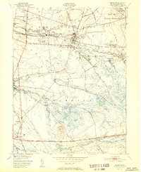
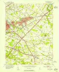
(36)- 1950 Map of Frankford, 1953 Print
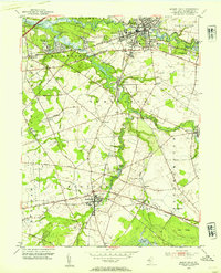
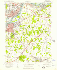
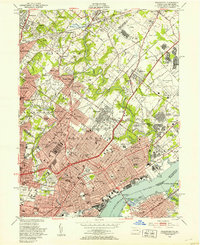 1950 Frankford1953 Print · USGSPhiladelphia in the mid-twentieth century shows a bustling industrial and institutional corridor along the Delaware River. Genealogists and historians can trace neighborhood growth through local landmarks like Montefiore Cemetery, Frankford High Sch, and the historic Frankford Arsenal.2 unique versions available
 - 1951 Map of Indian Mills
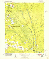
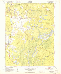 1951 Indian Mills1951 Print · USGSThe Pine Barrens of Burlington County are shown here in the early fifties, a landscape defined by berry agriculture and historic industry. Genealogists and researchers can locate old sites like Hampton Furnace, the rail line at High Crossing, and the community of Tabernacle.2 unique versions available
 - 1951 Map of Woodmansie
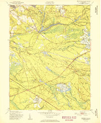
 1951 Woodmansie1951 Print · USGSThe New Jersey Pine Barrens are captured here in the early fifties, showing a landscape of state forests and specialized agriculture. Researchers can trace the Central Railroad of New Jersey through Woodmansie or locate old Cranberry Bogs and the Coyle Airport.2 unique versions available
 - 1951 Map of Browns Mills
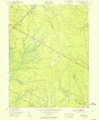
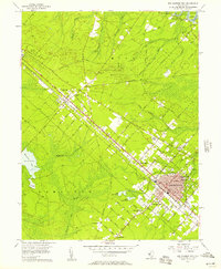
 1951 Browns Mills1951 Print · USGSMid-century Burlington County is defined here by military expansion and the agricultural heritage of the Pine Barrens. Researchers can trace historic industrial sites and unique settlements like Whitesbog, Ongs Hat, and the specialized Cranberry Bogs of the region.
 - 1951 Map of Pemberton
 1951 Pemberton1951 Print · USGSBurlington County enters the early fifties with a landscape defined by the Rancocas Creek forks and the expanding presence of the military. Trace local history through the Brick Kilns at Birmingham, the rural crossroads of Comical Corners, and the working Budds Cranberry Bogs.2 unique versions available
 - 1951 Map of Whiting
 1951 Whiting1951 Print · USGSThe New Jersey Pine Barrens are captured here at mid-century, defined by the heavy rail corridors of the Pennsylvania Railroad and military lands. Researchers can trace the layout of Whiting, follow the network of Cranberry Bogs, and locate remote sites like Pasadena and Bullock.
 - 1951 Map of Chatsworth
 1951 Chatsworth1951 Print · USGSBurlington County’s pine barrens are captured here in the early fifties, showing a landscape defined by the Central Railroad of New Jersey and cranberry production. Trace the early footprints of Chatsworth, the Zing Ore Refinery, and isolated settlements like Speedwell and Friendship.2 unique versions available
 - 1951 Map of New Gretna, 1954 Print
 1951 New Gretna1954 Print · USGSThe coastal wetlands of Burlington and Atlantic counties are captured here in the early fifties, just as the Garden State Parkway was being built. Genealogists can trace family lines near New Gretna, Port Republic, and the Hillside Cem.7 unique versions available
 - 1953 Map of Clementon, 1954 Print
 1953 Clementon1954 Print · USGSCamden County was a landscape of rail-linked towns and cranberry bogs in the early fifties. Genealogists and local historians can trace the foundations of Berlin, Gibbsboro, and Atco along the Pennsylvania-Reading Seashore Lines.3 unique versions available
 - 1953 Map of Atsion, 1954 Print
 1953 Atsion1954 Print · USGSThe New Jersey Pine Barrens in the early fifties reveal a landscape shaped by water and iron history. Trace the legacy of early settlements and agriculture through the Central Railroad of New Jersey, the sprawling Cranberry Bogs, and historic river crossings at Quaker Bridge.6 unique versions available
 - 1953 Map of Moorestown, 1954 Print
 1953 Moorestown1954 Print · USGSMoorestown and the surrounding Burlington County landscape are captured during the early postwar expansion, just as the New Jersey Turnpike reshaped the region. Genealogists and local historians can trace local family roots through sites like Jacobs Chapel, Cropwell Cem, and the various Township Schools that dotted these rural communities.2 unique versions available
 - 1953 Map of Medford Lakes, 1954 Print
 1953 Medford Lakes1954 Print · USGSThe Pine Barrens of Burlington and Camden Counties appear in detail in the early fifties, showing the region's unique cranberry-based economy. Researchers can trace rural school locations like Louden Sch and agricultural landmarks such as West Jersey Cranberry Meadow.2 unique versions available
 - 1953 Map of Hammonton, 1954 Print
 1953 Hammonton1954 Print · USGSThe Hammonton area in the early fifties shows the New Jersey Pinelands as a vital hub of rail commerce and cranberry cultivation. Genealogists and historians can trace family locations through sites like Bates Mill Cem, Chesilhurst Sta, and Winslow Junction.2 unique versions available
 - 1953 Map of Mount Holly, 1954 Print
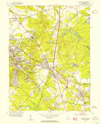
 1953 Mount Holly1954 Print · USGSMid-century Burlington County comes alive in this survey of the river-laced corridor between MOUNT HOLLY and Medford. Trace the ancestral roots of the region through family landmarks like Kirbys Mill, Peacock Cem, and the historic Cranberry Bogs.2 unique versions available
 - 1955 Map of Wilmington
 1955 Wilmington1955 Print · USGSThe Delaware Valley and Jersey Shore are seen here during the mid-fifties era of rapid suburban expansion and highway development. You can trace the path of the New Jersey Turnpike, locate the Fort Dix Military Reservation, or explore the rail networks of the Pennsylvania Railroad.
 - 1955 Map of Oswego Lake, 1956 Print
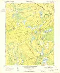
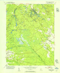
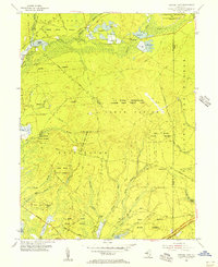 1955 Oswego Lake1956 Print · USGSIn the mid-fifties, this Pine Barrens landscape was a mix of state forests and new federal military installations. Genealogists and historians can trace old homesteads and crossings at Leektown, Sim Place, and Bartletts Bridge amidst the sprawling Penn State Forest.4 unique versions available
 - 1955 Map of Trenton West, 1957 Print
 1955 Trenton West1957 Print · USGSThe Delaware Valley transformed during the mid-fifties as planned communities like Levittown and Fairless Hills rose beside the river. Researchers can trace early suburban development through family-centric neighborhoods like Oaktree Hollow and landmarks like Rider College or the 3 M Airport.5 unique versions available
 - 1955 Map of Beverly, 1957 Print
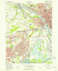
 1955 Beverly1957 Print · USGSThe Delaware River corridor hums with mid-century activity in this detailed survey of the Pennsylvania-New Jersey border. Genealogists and researchers can trace the developed neighborhoods of Beverly and Riverside or locate ancestors at the Beverly National Cemetery and Monument Cem.3 unique versions available
 - 1955 Map of Bristol, 1957 Print
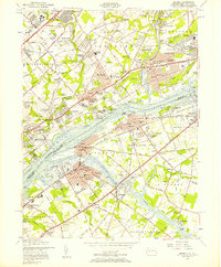
 1955 Bristol1957 Print · USGSThe Delaware Valley was undergoing significant post-war development in the mid-fifties, bridging the river between New Jersey and Pennsylvania. Genealogists can locate family plots at Odd Fellows Cem or trace old community roots in Timbuctoo and Roebling.5 unique versions available
 - 1956 Map of Newark
 1956 Newark1956 Print · USGSThe industrial heart of the Mid-Atlantic is captured here at the dawn of the highway era, tracing the dense corridors between Newark and Philadelphia. Genealogists and local historians can map the rail networks of the Reading RR or locate mid-century military life at Fort Dix Military Reservation.2 unique versions available
 - 1956 Map of Egg Harbor City, 1957 Print
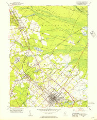
 1956 Egg Harbor City1957 Print · USGSAtlantic County during the mid-fifties shows a fascinating transition between the developed grids of Egg Harbor City and the surrounding pine barrens. Genealogists and historians can trace family locations near St Nicholas Ch, Laurel Hill Cem, and the old Amotol Race Track.6 unique versions available
 - 1956 Map of Jenkins, 1957 Print
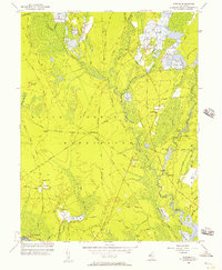 1956 Jenkins1957 Print · USGSThe New Jersey Pine Barrens are captured here in the mid-1950s, showing a landscape of bog agriculture and isolated settlements. Trace family roots and local history through St Andrews Ch and remote outposts like Harrisville or Washington Ruin.3 unique versions available
 - 1956 Map of Green Bank, 1957 Print
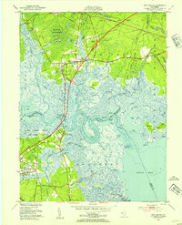
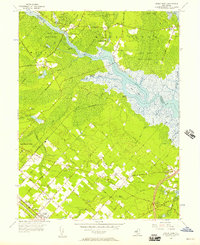 1956 Green Bank1957 Print · USGSCoastal New Jersey in the mid-1950s reveals a unique blend of planned settlements and preserved wilderness along the Mullica River. Researchers can trace early family sites at Clarks Mill Burying Ground or explore the rail network of the Pennsylvania-Reading Seashore Lines.4 unique versions available
 - 1957 Map of Wilmington
 1957 Wilmington1957 Print · USGSThe mid-Atlantic coastal plain comes alive in the mid-fifties as the New Jersey Turnpike and Garden State Parkway redefine travel. Researchers can trace the rail-to-road transition and find landmarks like Ship John Shoal Light and the Fort Dix Military Reservation.2 unique versions available
 - 1957 Map of Newark
 1957 Newark1957 Print · USGSThe industrial and military heart of the Mid-Atlantic is mapped during its post-war suburban boom. Genealogists and historians can trace the intricate rail corridors of the Reading Railroad and locate key landmarks from Princeton University to Fort Hancock.
Showing maps 1-25 of 36
Top cities of Burlington County
- Mount Laurel Township historical maps
- Willingboro Township historical maps
- Medford Township historical maps
- Moorestown Township historical maps
- Maple Shade Township historical maps
- Delran Township historical maps
See more
Frequently asked questions
- What are the different types of historical maps available for Burlington County?
- What is the oldest map of Burlington County?
- Where can I purchase historical maps of Burlington County for my home or office?
- Where can I download high-res historical maps of Burlington County?
- Are there historical topographic maps available for Burlington County?
- Is there historical aerial imagery available for Burlington County?
- Where are historical maps of Burlington County sourced from?