1990s Maps of Burlington County, New Jersey
Explore 15 historic maps of Burlington County from the 1990s. These maps offer a rare glimpse into what life looked like during the 1990s — showing old roads, neighborhoods, homes, and landmarks that have changed or disappeared over time.
Whether you're researching your family's past, planning a metal detecting trip, or studying how Burlington County's landscape evolved across the 1990s, these high-resolution maps are a powerful tool for exploring the history of this region.
- Focus on a specific era: All maps on this page are from the 1990s, giving you a focused view of this time period.
- See what’s changed: Compare century-old streets, trails, and buildings to today's modern landscape using overlays and satellite layers.
- Research with precision: Use these maps for genealogy, historical research, land use analysis, or educational projects.
- View, download, or print: Maps are fully viewable online in high resolution, and can be downloaded or printed for your own records.
Start exploring Burlington County's history through authentic maps from the 1990s. This is your window into the past.
Burlington County, NJ maps
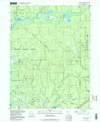
(15)- 1995 Map of Woodmansie, 1998 Print
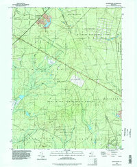 1995 Woodmansie1998 Print · USGSThe New Jersey Pine Barrens are captured in the mid-1990s, showing a landscape defined by protected state forests and commercial cranberry production. Researchers can trace the layout of Woodmansie, locate the Airfield, and identify numerous Cranberry Bogs and landmarks like Bear Swamp Hill.
 - 1995 Map of Trenton West, 1998 Print
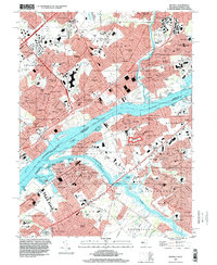
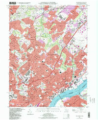
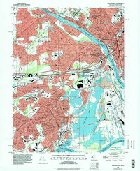 1995 Trenton West1998 Print · USGSThe Delaware River corridor between Trenton and Levittown is captured here in the mid-nineties, showing decades of suburban and industrial evolution. Trace local family history through Riverview Cemetery, St Andrews Ch, and the many schools like William Penn High Sch.
 - 1995 Map of Moorestown, 1998 Print
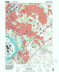
 1995 Moorestown1998 Print · USGSSouth Jersey's suburban landscape reached a peak of development in the late nineties, centered on the busy intersection of the New Jersey Turnpike. Researchers can trace the layout of residential tracts like Heritage Village or locate historic sites like Colestown Cemetery and the Cistercian Monastery.
 - 1995 Map of Allentown, 1999 Print
 1995 Allentown1999 Print · USGSCentral New Jersey's transition from rural mill towns to a modern suburban landscape is clear in this late-century survey. Genealogists and historians can trace family roots through St Johns Ch, find former hubs like Davis Station, or locate old mill sites at Walnford and Kirbys Mills.
 - 1995 Map of Camden, 1999 Print
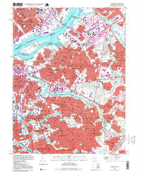 1995 Camden1999 Print · USGSThe Delaware River waterfront in the 1990s remains a hub of industry and transit connecting New Jersey to Philadelphia. Family researchers can trace deep roots through detailed layouts of Harleigh Cemetery, Old Camden Cemetery, and dozens of local parish schools like St Josephs High Sch.
 - 1995 Map of Beverly, 2000 Print
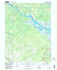
 1995 Beverly2000 Print · USGSCrossing the Delaware during the mid-1990s reveals a suburban landscape still deeply shaped by its riverfront heritage and industrial rail corridors. Genealogists can trace family sites from Beverly National Cemetery to the Philadelphia State Hospital or the historic Byberry Chapel.
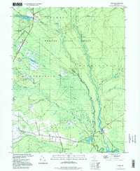
 - 1995 Map of Indian Mills, 2000 Print
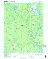
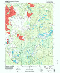 1995 Indian Mills2000 Print · USGSThe Pine Barrens of Burlington County appear in the mid-1990s as a landscape of forest preservation and agricultural tradition. Local historians can trace the heritage of the cranberry industry through Cranberry Bogs and find old sites like Hampton Furnace and Moores Mill.
 - 1995 Map of Chatsworth, 2000 Print
 1995 Chatsworth2000 Print · USGSThe heart of the New Jersey Pine Barrens is captured here during the 1990s, showcasing the unique cranberry-growing heritage of the region. Researchers can trace historic settlements and isolated family landmarks like Johnson Place, Friendship, and the high point at Apple Pie Hill.
 - 1995 Map of Trenton East, 2000 Print
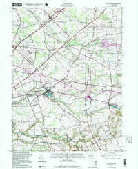
 1995 Trenton East2000 Print · USGSMercer County communities east of the state capital are shown in the mid-nineties as the corridor between Trenton and Bordentown continued to develop. Researchers can trace local landmarks like Greenwood Cemetery, the State Industrial School, and Hamilton Square.
 - 1997 Map of Jenkins, 1998 Print
 1997 Jenkins1998 Print · USGSThe New Jersey Pine Barrens are captured here in the late twentieth century, showing a landscape defined by cranberry culture and old forest ruins. Genealogists and local historians can trace family-named sites like Bulltown and Crowleytown or locate the Washington Ruin and St Andrews Ch.
 - 1997 Map of Browns Mills, 1998 Print
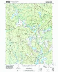
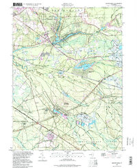 1997 Browns Mills1998 Print · USGSThe Pine Barrens of Burlington County are shown here in the late twentieth century, centered on the historic cranberry industry and military borders. Researchers can locate the famed Whitesbog plantation, the Deborah Sanatorium, and the industrial site of Hanover Furnace.
 - 1997 Map of Frankford, 1998 Print
 1997 Frankford1998 Print · USGSNortheast Philadelphia and its bordering Montgomery County suburbs are shown in high detail during the late nineties. Genealogists and local historians can trace legacy sites like Montefiore Cemetery, the Aviation Supply Office, and neighborhoods from Rockledge to Torresdale.
 - 1997 Map of Green Bank, 1998 Print
 1997 Green Bank1998 Print · USGSThe Mullica River valley and the German-influenced streets of Egg Harbor City are captured here in the late nineties. Local researchers can trace family landmarks like Clarks Mill Burying Ground, Snyder Sch, and the riverside sites of Lower Bank and Clarks Landing.
 - 1997 Map of Oswego Lake, 1998 Print
 1997 Oswego Lake1998 Print · USGSThe Pine Barrens of the late nineties are defined here by the intersection of four major state forests and the winding Wading River. Researchers can trace historic local sites like Sim Place and Leektown, or find old river crossings at Bartletts Bridge and Dans Bridge.
 - 1997 Map of Atsion, 1998 Print
 1997 Atsion1998 Print · USGSThe New Jersey Pine Barrens are captured here in the late nineties, showing a landscape defined by the Mullica River and legacy cranberry production. Genealogists and historians can trace old community centers at Batsto and Pleasant Mills or locate the Nesco Sch and numerous Cranberry Bogs tucked into the Great Swamp.
End of results
Showing maps 1-15 of 15
Top cities of Burlington County
- Mount Laurel Township historical maps
- Willingboro Township historical maps
- Medford Township historical maps
- Moorestown Township historical maps
- Maple Shade Township historical maps
- Delran Township historical maps
See more
Frequently asked questions
- What are the different types of historical maps available for Burlington County?
- What is the oldest map of Burlington County?
- Where can I purchase historical maps of Burlington County for my home or office?
- Where can I download high-res historical maps of Burlington County?
- Are there historical topographic maps available for Burlington County?
- Is there historical aerial imagery available for Burlington County?
- Where are historical maps of Burlington County sourced from?