Old Maps of Chesterfield Township, New Jersey for Academic Research
Study the evolution of Chesterfield Township with 45 high-resolution historic maps. Whether you're teaching, researching, or modeling changes in land use, these maps provide essential visual documentation of urban, environmental, and geographic change.
- Analyze long-term change: Track patterns in development, transportation, and natural features.
- Ideal for environmental or urban studies: Support academic projects with primary historical map data.
- Use in the classroom or lab: Educators and researchers rely on these maps to bring historical context to life.
These maps are a powerful tool for teaching, research, and visualizing how Chesterfield Township has changed over the decades.
Chesterfield Township, NJ maps
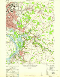
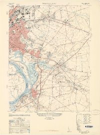
(45)- 1888 Map of Bordentown
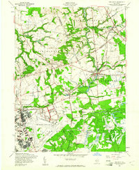
 1888 Bordentown1888 Print · USGSCentral New Jersey in the 1880s was a bustling corridor of river commerce and intersecting rail lines. Genealogists and local historians can trace the early footprints of Bordentown, locate the junctions of the Pennsylvania Railroad, and find rural settlements like Recklesstown and Arneytown.
 - 1893 Map of Bordentown
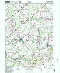
 1893 Bordentown1893 Print · USGSCentral New Jersey in the late nineteenth century was a bustling corridor of rail lines and established river towns. Genealogists and historians can trace the early footprints of Bordentown, Hamilton Square, and the various branches of the Pennsylvania Railroad.3 unique versions available
 - 1906 Map of Bordentown
 1906 Bordentown1906 Print · USGSThe Delaware River corridor and Burlington County interior are seen here in the early 1900s, showing a landscape shaped by rail and river commerce. Genealogists can trace early homesteads and hamlets near Bordentown, Hamilton Square, and the mills at Walnford.6 unique versions available
 - 1907 Map of Trenton
 1907 Trenton1907 Print · USGSThe Delaware River valley hums with turn-of-the-century industry and transport as river canals and railroads converge between New Jersey and Pennsylvania. Genealogists and local historians can trace the footprint of the George School, find early post offices like Holland PO, or locate old mill sites such as Blackwells Mills.4 unique versions available
 - 1918 Map of Camp Dix
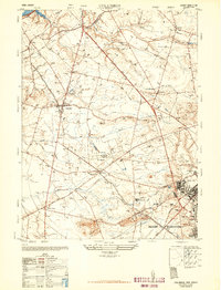
 1918 Camp Dix1918 Print · USGSNew Jersey at the height of the Great War features the sprawling mobilization grounds of Camp Dix and its expansive Rifle Range. Genealogists and historians can trace defunct stops like Imlaystown Sta or locate family roots near New Egypt and Colliers Mill.2 unique versions available
 - 1944 Map of Newark, 1971 Print
 1944 Newark1971 Print · USGSThe industrial corridor from Philadelphia to New York was in a period of massive transition during the mid-forties. Genealogists and researchers can trace the rail lines of the Lehigh Valley RR, locate military installations like Picatinny Arsenal, and explore the early sprawl near Levittown.5 unique versions available
 - 1947 Map of Trenton East
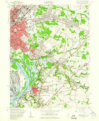
 1947 Trenton East1947 Print · USGSMercer County and the Delaware River waterfront are captured here just after the war as industrial hubs and suburban neighborhoods began to expand. Genealogists and historians can trace the foundations of Warner Village, locate the Bordentown Cemetery, or find the Pennsylvania Maritime Academy along the riverbank.
 - 1948 Map of Columbus
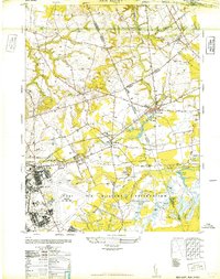
 1948 Columbus1948 Print · USGSBurlington County in the late nineteen-forties shows a landscape of productive dairies and growing military installations. Researchers can trace the layout of the Fort Dix Military Reservation or locate family roots near Mansfield Square and the Helis Stock Farm.2 unique versions available
 - 1948 Map of New Egypt
 1948 New Egypt1948 Print · USGSPost-war Burlington and Ocean counties are defined here by a massive military footprint and the traditional cranberry industry. Genealogists and historians can trace the early layouts of New Egypt and Wrightstown or locate family landmarks like Cranberry Hall.3 unique versions available
 - 1948 Map of Allentown
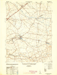 1948 Allentown1948 Print · USGSMonmouth and Mercer counties meet here in the late 1940s, showing a landscape of established townships and crossroad settlements. Genealogists and local historians can trace family-named sites like Walnford, Nelsonville, and the East Windsor Cemetery.2 unique versions available
 - 1948 Map of Trenton East, 1949 Print
 1948 Trenton East1949 Print · USGSMercer County and its surroundings are documented here in the late 1940s as suburban expansion began to reshape the landscape. Local historians can trace the development of Warner Village and Hamilton Square or locate landmarks like the Pennsylvania Maritime Academy and Bordentown Cemetery.
 - 1948 Map of Bordentown, 1954 Print
 1948 Bordentown1954 Print · USGSCentral New Jersey stands at the crossroads of military expansion and early highway development in the years following the war. Genealogists and historians can trace the rural layouts of Bordentown and New Egypt or locate landmarks like Arneys Mount and the Pa Maritime Academy.2 unique versions available
 - 1949 Map of Newark
 1949 Newark1949 Print · USGSThe industrial corridor between Philadelphia and New York comes alive in this post-war survey. Genealogists and historians can trace the massive rail networks of the Reading Railroad and locate major installations like Fort Dix or Picatinny Arsenal.2 unique versions available
 - 1956 Map of Newark
 1956 Newark1956 Print · USGSThe industrial heart of the Mid-Atlantic is captured here at the dawn of the highway era, tracing the dense corridors between Newark and Philadelphia. Genealogists and local historians can map the rail networks of the Reading RR or locate mid-century military life at Fort Dix Military Reservation.2 unique versions available
 - 1957 Map of Newark
 1957 Newark1957 Print · USGSThe industrial and military heart of the Mid-Atlantic is mapped during its post-war suburban boom. Genealogists and historians can trace the intricate rail corridors of the Reading Railroad and locate key landmarks from Princeton University to Fort Hancock.
 - 1957 Map of Trenton East, 1960 Print
 1957 Trenton East1960 Print · USGSMid-century development spreads eastward from the Delaware River during the late fifties as residential neighborhoods begin to fill the spaces between historic hamlets. Researchers can trace the era's institutional landscape at the State Reformatory, the State Fairgrounds, and local landmarks like St Anthonys Convent.6 unique versions available
 - 1957 Map of Allentown, 1961 Print
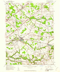 1957 Allentown1961 Print · USGSAllentown and its surrounding townships appear at a mid-century crossroads where quiet millponds meet the emerging New Jersey Turnpike. Researchers can trace family history through sites like St Johns Ch, Windsor Cem, and the milling hamlets of Walnford and Kirbys Mills.3 unique versions available
 - 1957 Map of Columbus, 1961 Print
 1957 Columbus1961 Print · USGSMid-century Burlington County shows a rural landscape transitioning toward the modern era as the interstate system meets historic farm townships. Trace local roots through Wallace Mill, the St Andrews Ch, and the sprawling Fort Dix Military Reservation.5 unique versions available
 - 1957 Map of New Egypt, 1961 Print
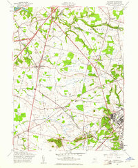
 1957 New Egypt1961 Print · USGSMid-century Ocean and Burlington Counties are defined by the intersection of massive military installations and rural township life. Genealogists and historians can trace the developments of Mc Guire Air Force Base alongside older settlements like Cookstown and the productive Cranberry Bogs.4 unique versions available
 - 1960 Map of Newark
 1960 Newark1960 Print · USGSThe industrial heart of the Mid-Atlantic is shown at mid-century, stretching from the dense urban centers of Newark and Philadelphia to the Blue Mountain ridges. Researchers can trace historic rail lines, coastal defenses at Fort Hancock, and the riverfront growth of Trenton and Easton.3 unique versions available
 - 1964 Map of Newark
 1964 Newark1964 Print · USGSGreater New Jersey and eastern Pennsylvania appear at the peak of their industrial and rail-centered development in the mid-sixties. Genealogists and historians can trace the paths of the Pennsylvania RR, identify mid-century landmarks like CAMP KILMER, or follow the Schuylkill River through READING.2 unique versions available
 - 1982 Map of Trenton, 1983 Print
 1982 Trenton1983 Print · USGSCentral New Jersey and the Delaware River valley are captured in the early eighties during a time of major highway expansion and suburban maturation. Researchers can trace the grounds of Princeton University, the historic Monmouth Battlefield, and the sprawling Fort Dix.
 - 1986 Map of Trenton, 1987 Print
 1986 Trenton1987 Print · USGSCentral New Jersey and the Delaware River valley are shown here during the mid-eighties, a period of dense suburban growth and military activity. Researchers can trace the sprawling grounds of the Fort Dix Military Reservation and the historic corridors of the Delaware & Raritan Canal State Park.
 - 1995 Map of Allentown, 1999 Print
 1995 Allentown1999 Print · USGSCentral New Jersey's transition from rural mill towns to a modern suburban landscape is clear in this late-century survey. Genealogists and historians can trace family roots through St Johns Ch, find former hubs like Davis Station, or locate old mill sites at Walnford and Kirbys Mills.
 - 1995 Map of Trenton East, 2000 Print
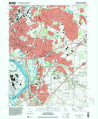 1995 Trenton East2000 Print · USGSMercer County communities east of the state capital are shown in the mid-nineties as the corridor between Trenton and Bordentown continued to develop. Researchers can trace local landmarks like Greenwood Cemetery, the State Industrial School, and Hamilton Square.
Showing maps 1-25 of 45
Top cities near Chesterfield Township
- Hamilton Township historical maps
- Trenton historical maps
- Jackson Township historical maps
- Levittown historical maps
- Monroe Township historical maps
- South Brunswick historical maps
See more
Top neighborhoods of Chesterfield Township
- Sykesville historical maps
- Wallace Mill historical maps
- Davisville historical maps
- Crosswicks historical maps
Frequently asked questions
- What are the different types of historical maps available for Chesterfield Township?
- What is the oldest map of Chesterfield Township?
- Where can I purchase historical maps of Chesterfield Township for my home or office?
- Where can I download high-res historical maps of Chesterfield Township?
- Are there historical topographic maps available for Chesterfield Township?
- Is there historical aerial imagery available for Chesterfield Township?
- Where are historical maps of Chesterfield Township sourced from?