Old Maps of Palmyra, New Jersey for Metal Detecting
Plan your next treasure hunt with 43 historic maps of Palmyra. Find old homesites, ghost towns, trails, and gathering spots that may be lost to time — perfect for identifying promising metal detecting locations.
- Locate forgotten sites: Uncover places like long-lost settlements, abandoned rail lines, or gathering spots.
- Plan better hunts: Use map overlays combined with LiDAR or satellite views to narrow in on historically rich areas.
- Made for detectorists: Thousands of hobbyists use these maps to discover relics, coins, and hidden history.
Use these historic maps to boost your research and find new opportunities beneath the surface of Palmyra.
Palmyra, NJ maps
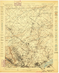
(43)- 1891 Map of Philadelphia
 1891 Philadelphia1891 Print · USGSPhiladelphia and its New Jersey neighbors are captured in the late Victorian era as rail and river commerce defined the region. Genealogists and historians can trace family-named sites and vanished river features like Windmill Island, Haddonfield, and the U.S. Navy Yard.
 - 1893 Map of Germantown
 1893 Germantown1893 Print · USGSThe outskirts of Philadelphia and Montgomery County are shown in the late nineteenth century as rail lines transformed rural townships. Genealogists and historians can trace old property lines and depots from Warminster P.O. to the U.S. Arsenal.
 - 1894 Map of Philadelphia, 1958 Print
 1894 Philadelphia1958 Print · USGSPhiladelphia and Camden are shown at the height of the Victorian era, characterized by dense rail corridors and a bustling maritime waterfront. Genealogists and researchers can trace 19th-century neighborhoods and landmarks like Fort Mifflin, Paschallville, and the Alms House.
 - 1894 Map of Germantown, 1961 Print
 1894 Germantown1961 Print · USGSThe northern Philadelphia suburbs and rural Montgomery County are captured here just as the railroad was transforming local life. Genealogists can trace family names and old property lines across Germantown, Hatboro, and the historic U.S. Arsenal.
 - 1896 Map of Germantown
 1896 Germantown1896 Print · USGSThe northern reaches of Philadelphia and lower Bucks County are shown in the late nineteenth century as rail lines transformed rural villages into bustling suburbs. Trace early transport routes along Street Road or locate family landmarks near Hatboro, Ambler, and the U. S. Arsenal.
 - 1896 Map of Philadelphia
 1896 Philadelphia1896 Print · USGSPhiladelphia and its South Jersey neighbors appear at a peak of late-nineteenth-century industrial and maritime expansion. Genealogists and historians can trace the early layouts of Woodbury and Gloucester, or locate landmarks like Fort Mifflin and the U.S. Navy Yard along the riverfront.
 - 1898 Map of Philadelphia
 1898 Philadelphia1898 Print · USGSPhiladelphia and Camden emerge as a Victorian-era industrial powerhouse at the turn of the century, knit together by ferry and rail. Researchers can trace ancestral roots in vanished neighborhoods like Paschallville or locate landmarks like the Alms House and Fort Mifflin.9 unique versions available
 - 1899 Map of Germantown
 1899 Germantown1899 Print · USGSPhiladelphia and its northern townships are documented in the late nineteenth century as the suburban rail network expanded. Genealogists can trace family roots through historic settlements like Hatboro, Ambler, and the neighborhood of Chestnut Hill.9 unique versions available
 - 1901 Map of Camden
 1901 Camden1901 Print · USGSThe Delaware River valley at the turn of the century shows a bustling corridor of early industrial growth and established mill towns. Researchers can trace the heritage of local industry at Sycamore Mills or locate early settlements like Penns Grove and Village Green.3 unique versions available
 - 1920 Map of Philadelphia
 1920 Philadelphia1920 Print · USGSPhiladelphia and its New Jersey neighbors are captured here just after the Great War, showing a landscape defined by massive riverfront industry and a dense rail network. Genealogists can trace family footprints through numerous small communities and stations like Blenheim Station, Woodbury Heights, and the grounds of the Alms House.
 - 1942 Map of Norristown
 1942 Norristown1942 Print · USGSSoutheastern Pennsylvania at the onset of World War II shows a landscape of busy industrial river towns and expanding rail suburbs. Genealogists and historians can trace the early transit networks connecting Norristown, Doylestown, and the riverfront at New Hope.
 - 1942 Map of Camden
 1942 Camden1942 Print · USGSThe Philadelphia and Camden metropolitan corridor is captured here at the height of the Second World War. Genealogists and historians can trace rail networks like the Reading R.R. and locate communities from Swedesboro to Merchantville.
 - 1943 Map of Philadelphia
 1943 Philadelphia1943 Print · USGSPhiladelphia and Camden are shown at their wartime peak, anchored by the industrial activity of the Delaware River waterfront. Genealogists and historians can trace rail-connected neighborhoods and landmarks like the U. S. Navy Yard, Fort Mifflin, and the Alms House.
 - 1944 Map of Newark, 1971 Print
 1944 Newark1971 Print · USGSThe industrial corridor from Philadelphia to New York was in a period of massive transition during the mid-forties. Genealogists and researchers can trace the rail lines of the Lehigh Valley RR, locate military installations like Picatinny Arsenal, and explore the early sprawl near Levittown.5 unique versions available
 - 1946 Map of Wilmington, 1948 Print
 1946 Wilmington1948 Print · USGSThe Delaware Valley and Jersey Shore emerge in this mid-century portrait of a region defined by river commerce and seaside growth. Genealogists and historians can trace the rail networks of the Pennsylvania Railroad, locate early airfields like Dover Airpark, and find river defenses at Fort Delaware.2 unique versions available
 - 1949 Map of Newark
 1949 Newark1949 Print · USGSThe industrial corridor between Philadelphia and New York comes alive in this post-war survey. Genealogists and historians can trace the massive rail networks of the Reading Railroad and locate major installations like Fort Dix or Picatinny Arsenal.2 unique versions available
 - 1949 Map of Camden, 1953 Print
 1949 Camden1953 Print · USGSPost-war New Jersey and Pennsylvania are captured here at the height of their industrial and suburban expansion. Genealogists can locate family plots in Harleigh Cem or Locustwood Cemetery while tracing the vanished Central Airport.3 unique versions available
 - 1950 Map of Frankford, 1953 Print
 1950 Frankford1953 Print · USGSPhiladelphia in the mid-twentieth century shows a bustling industrial and institutional corridor along the Delaware River. Genealogists and historians can trace neighborhood growth through local landmarks like Montefiore Cemetery, Frankford High Sch, and the historic Frankford Arsenal.2 unique versions available
 - 1955 Map of Wilmington
 1955 Wilmington1955 Print · USGSThe Delaware Valley and Jersey Shore are seen here during the mid-fifties era of rapid suburban expansion and highway development. You can trace the path of the New Jersey Turnpike, locate the Fort Dix Military Reservation, or explore the rail networks of the Pennsylvania Railroad.
 - 1956 Map of Newark
 1956 Newark1956 Print · USGSThe industrial heart of the Mid-Atlantic is captured here at the dawn of the highway era, tracing the dense corridors between Newark and Philadelphia. Genealogists and local historians can map the rail networks of the Reading RR or locate mid-century military life at Fort Dix Military Reservation.2 unique versions available
 - 1957 Map of Wilmington
 1957 Wilmington1957 Print · USGSThe mid-Atlantic coastal plain comes alive in the mid-fifties as the New Jersey Turnpike and Garden State Parkway redefine travel. Researchers can trace the rail-to-road transition and find landmarks like Ship John Shoal Light and the Fort Dix Military Reservation.2 unique versions available
 - 1957 Map of Newark
 1957 Newark1957 Print · USGSThe industrial and military heart of the Mid-Atlantic is mapped during its post-war suburban boom. Genealogists and historians can trace the intricate rail corridors of the Reading Railroad and locate key landmarks from Princeton University to Fort Hancock.
 - 1959 Map of Wilmington
 1959 Wilmington1959 Print · USGSThe Delaware Valley and Jersey Shore are seen here in the late fifties, during a period of massive suburban and highway expansion. Researchers can trace mid-century infrastructure like the N J Turnpike or locate coastal landmarks from Barnegat Bay to the Maurice River.3 unique versions available
 - 1960 Map of Newark
 1960 Newark1960 Print · USGSThe industrial heart of the Mid-Atlantic is shown at mid-century, stretching from the dense urban centers of Newark and Philadelphia to the Blue Mountain ridges. Researchers can trace historic rail lines, coastal defenses at Fort Hancock, and the riverfront growth of Trenton and Easton.3 unique versions available
 - 1964 Map of Newark
 1964 Newark1964 Print · USGSGreater New Jersey and eastern Pennsylvania appear at the peak of their industrial and rail-centered development in the mid-sixties. Genealogists and historians can trace the paths of the Pennsylvania RR, identify mid-century landmarks like CAMP KILMER, or follow the Schuylkill River through READING.2 unique versions available
Showing maps 1-25 of 43
Top cities near Palmyra
- Philadelphia historical maps
- Trenton historical maps
- Upper Darby historical maps
- Camden historical maps
- Cherry Hill Township historical maps
- Bensalem Township historical maps
See more
Frequently asked questions
- What are the different types of historical maps available for Palmyra?
- What is the oldest map of Palmyra?
- Where can I purchase historical maps of Palmyra for my home or office?
- Where can I download high-res historical maps of Palmyra?
- Are there historical topographic maps available for Palmyra?
- Is there historical aerial imagery available for Palmyra?
- Where are historical maps of Palmyra sourced from?