1990s Maps of Dennis Township, New Jersey
Explore 3 historic maps of Dennis Township from the 1990s. These maps offer a rare glimpse into what life looked like during the 1990s — showing old roads, neighborhoods, homes, and landmarks that have changed or disappeared over time.
Whether you're researching your family's past, planning a metal detecting trip, or studying how Dennis Township's landscape evolved across the 1990s, these high-resolution maps are a powerful tool for exploring the history of this region.
- Focus on a specific era: All maps on this page are from the 1990s, giving you a focused view of this time period.
- See what’s changed: Compare century-old streets, trails, and buildings to today's modern landscape using overlays and satellite layers.
- Research with precision: Use these maps for genealogy, historical research, land use analysis, or educational projects.
- View, download, or print: Maps are fully viewable online in high resolution, and can be downloaded or printed for your own records.
Start exploring Dennis Township's history through authentic maps from the 1990s. This is your window into the past.
Dennis Township, NJ maps
(3)- 1994 Map of Avalon, 1998 Print
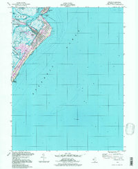 1994 Avalon1998 Print · USGSThe Jersey Shore of the 1990s comes alive in this detailed record of Avalon and the northern tip of Stone Harbor. Local historians and boaters can trace the development of Seven Mile Beach, from the Boardwalk to the man-made inlets of Princeton Harbor.
 - 1994 Map of Port Elizabeth, 1998 Print
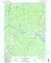
 1994 Port Elizabeth1998 Print · USGSThe Maurice River corridor near Port Elizabeth comes to life in the 1990s, showing a landscape shaped by river commerce and heavy conservation. Researchers can trace the layout of historic settlements like Dorchester, find the Leesburg Sch, and locate old industrial sites like Hoffmans Mill.
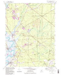
 - 1994 Map of Tuckahoe, 1998 Print
 1994 Tuckahoe1998 Print · USGSSouthern New Jersey in the 1990s reveals a landscape defined by the Tuckahoe River and vast state conservation lands. Genealogists and historians can trace old community ties through locations like Steelmantown, Marshallville, and the remote Hunters Mill.
End of results
Showing maps 1-3 of 3
Top cities near Dennis Township
- Vineland historical maps
- Egg Harbor Township historical maps
- Galloway Township historical maps
- Millville historical maps
- Hamilton Township historical maps
- Lower Township historical maps
See more
Top neighborhoods of Dennis Township
- Clermont historical maps
- Dennisville historical maps
- North Dennis historical maps
- Belleplain historical maps
- Cedar Grove historical maps
- Eldora historical maps
See more
Frequently asked questions
- What are the different types of historical maps available for Dennis Township?
- What is the oldest map of Dennis Township?
- Where can I purchase historical maps of Dennis Township for my home or office?
- Where can I download high-res historical maps of Dennis Township?
- Are there historical topographic maps available for Dennis Township?
- Is there historical aerial imagery available for Dennis Township?
- Where are historical maps of Dennis Township sourced from?