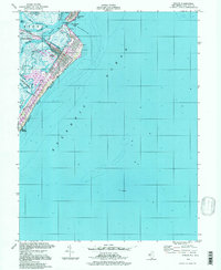
1994 Map of Avalon
USGS Topo · Published 1998About this map
Seven Mile Beach and the developed waterfront of Avalon define this New Jersey coastal survey. The map details a landscape of barrier island urbanization and extensive tidal marshlands, including the protected Cape May Wetlands Wildlife Management Area. Beyond the Boardwalk and grid of residential streets, a complex network of channels and sounds such as Stites Sound, North Channel, and Ingram Thorofare weave through the back bay. Modern infrastructure is evident in the man-made inlets of Cornell Harbor, Pennsylvania Harbor, and Princeton Harbor, which showcase the mid-century transformation of the shoreline for maritime recreation. Boaters and coastal historians can trace the Intracoastal Waterway as it passes the Avalon Yacht Club and moves toward Townsends Inlet. The map also captures the northern edge of Stone Harbor and includes offshore soundings in the Atlantic Ocean, including the location of submerged Wreckage.
Find a feature on this map
32 named features on this map. Tap any name to fly to it.
Don’t see what you’re looking for? This feature index may not catch every label — zoom into the map to look around manually.
Map Details
Editions of this 1994 Avalon Map
This is the sole edition of this map. No revisions or reprints were ever made.
Other maps of this area

1884 · Sea Isle
USGS Topo · 1:62,500

1888 · Cape May
USGS Topo · 1:62,500

1888 · Dennisville
USGS Topo · 1:62,500

1888 · Sea Isle
USGS Topo · 1:62,500

1893 · Cape May
USGS Topo · 1:62,500

1894 · Dennisville
USGS Topo · 1:62,500

1894 · Sea Isle
USGS Topo · 1:62,500

1898 · Cape May
USGS Topo · 1:62,500

1918 · Cape May
USGS Topo · 1:62,500

1919 · Sea Isle
USGS Topo · 1:62,500