1900s (20th Century) Maps of Vineland, New Jersey
Explore 28 historic maps of Vineland from the 1900s (20th Century). These maps offer a rare glimpse into what life looked like during the 1900s — showing old roads, neighborhoods, homes, and landmarks that have changed or disappeared over time.
Whether you're researching your family's past, planning a metal detecting trip, or studying how Vineland's landscape evolved across the 1900s, these high-resolution maps are a powerful tool for exploring the history of this region.
- Focus on a specific era: All maps on this page are from the 1900s, giving you a focused view of this time period.
- See what’s changed: Compare century-old streets, trails, and buildings to today's modern landscape using overlays and satellite layers.
- Research with precision: Use these maps for genealogy, historical research, land use analysis, or educational projects.
- View, download, or print: Maps are fully viewable online in high resolution, and can be downloaded or printed for your own records.
Start exploring Vineland's history through authentic maps from the 1900s. This is your window into the past.
Vineland, NJ maps
(28)- 1900 Map of Rancocas
 1900 Rancocas1900 Print · USGSSouthern New Jersey at the turn of the century reveals a land of timber, mills, and emerging rail junctions. Genealogists and historians can trace the locations of family-owned landmarks like Jennings Mill, Ballingers Mill, and early settlements such as Colemantown and Fellowship.2 unique versions available
 - 1901 Map of Camden
 1901 Camden1901 Print · USGSThe Delaware River valley at the turn of the century shows a bustling corridor of early industrial growth and established mill towns. Researchers can trace the heritage of local industry at Sycamore Mills or locate early settlements like Penns Grove and Village Green.3 unique versions available
 - 1918 Map of Tuckahoe, 1921 Print
 1918 Tuckahoe1921 Print · USGSSouthern New Jersey’s pine barrens and river valleys are captured here during a period of transition between early industry and railroad expansion. Genealogists and researchers can trace the locations of Walker's Forge, the West Jersey Railroad, and forgotten milling sites like Bennett Mill.
 - 1919 Map of Hammonton
 1919 Hammonton1919 Print · USGSThe Pine Barrens of the early twentieth century are defined here by a massive web of competing railroads and small mill settlements. Researchers can trace historic family landmarks and transit hubs like Winslow Junction, Iron Mills, and Pestletown during the region's peak agricultural era.
 - 1919 Map of Vineland, 1921 Print
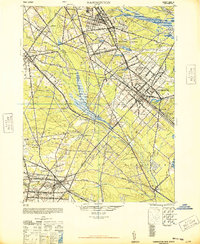
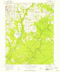
 1919 Vineland1921 Print · USGSCumberland County’s coastal oyster ports and inland industrial centers are captured here during a period of peak maritime activity. Genealogists and historians can trace rail lines like the Central R. R. of New Jersey or locate vanished sites like Whitehall Ldg. and Sheppards Mill.
 - 1941 Map of Tuckahoe
 1941 Tuckahoe1941 Print · USGSCoastal New Jersey at the start of the 1940s reveals a landscape defined by sand mining and a dense network of steam and electric rail. Genealogists and historians can trace the paths of the Pennsylvania Reading Seashore Lines through rural stops like Port Elizabeth, Mizpah, and Walkers Forge.
 - 1942 Map of Camden
 1942 Camden1942 Print · USGSThe Philadelphia and Camden metropolitan corridor is captured here at the height of the Second World War. Genealogists and historians can trace rail networks like the Reading R.R. and locate communities from Swedesboro to Merchantville.
 - 1942 Map of Hammonton
 1942 Hammonton1942 Print · USGSAtlantic and Camden counties come alive in the early 1940s, showing the South Jersey Pinelands just as the modern highway system began to overlap the old rail networks. Trace historical property lines and local hubs like Winslow Junction, Blue Anchor, and the waters of Hammonton Lake.
 - 1942 Map of Bridgeton
 1942 Bridgeton1942 Print · USGSCumberland County during the early war years shows a landscape of busy glass-making towns and rural farming hamlets connected by an intricate rail network. Researchers can trace the lines of the Central Railroad of New Jersey to old mills and landings like Shaws Mill and Tindells Landing.
 - 1946 Map of Wilmington, 1948 Print
 1946 Wilmington1948 Print · USGSThe Delaware Valley and Jersey Shore emerge in this mid-century portrait of a region defined by river commerce and seaside growth. Genealogists and historians can trace the rail networks of the Pennsylvania Railroad, locate early airfields like Dover Airpark, and find river defenses at Fort Delaware.2 unique versions available
 - 1948 Map of Glassboro
 1948 Glassboro1948 Print · USGSSouth Jersey's agricultural heartland and transit corridors are captured here just after the war, showing the area's transition into a modern produce hub. Genealogists can trace family names and small settlements like Brotmanville, Husted Station, and Seabrook Farms.3 unique versions available
 - 1948 Map of Bridgeton
 1948 Bridgeton1948 Print · USGSCumberland County at the close of the 1940s reveals a landscape defined by tidewater rivers and a maturing rail network. Researchers can trace the heritage of rural settlements like Gouldtown and Rosenhayn or locate historic industry at Lummis Mill and Mauricetown Station.3 unique versions available
 - 1948 Map of Hammonton
 1948 Hammonton1948 Print · USGSPost-war South Jersey is defined here by the meeting of rail and road, as the White Horse Pike cuts through the Pinelands. Trace the development of communities like Hammonton and the critical rail hub at Winslow Junction.2 unique versions available
 - 1953 Map of Newfield, 1954 Print
 1953 Newfield1954 Print · USGSSouthern New Jersey's transition from agricultural hinterland to rail-connected boroughs is captured here in the early fifties. Genealogists and researchers can trace family roots through Alliance, Brotmanville, and landmarks like Rose Hill Cem and Zion Ch.7 unique versions available
 - 1953 Map of Buena, 1954 Print
 1953 Buena1954 Print · USGSIn the early fifties, South Jersey was a patchwork of small truck farms and rural crossroads centered around Landisville and Minotola. Trace local history through landmarks like St Marys Cemetery, the Downstown Airfield, and Folsom.4 unique versions available
 - 1953 Map of Millville, 1955 Print
 1953 Millville1955 Print · USGSCumberland County thrived in the early fifties as a hub of rail transport and agriculture centered around the Maurice River. Genealogists and historians can trace family locations through numerous sites like Siloam Cem, Carmel, and the Sacred Heart Ch.4 unique versions available
 - 1955 Map of Wilmington
 1955 Wilmington1955 Print · USGSThe Delaware Valley and Jersey Shore are seen here during the mid-fifties era of rapid suburban expansion and highway development. You can trace the path of the New Jersey Turnpike, locate the Fort Dix Military Reservation, or explore the rail networks of the Pennsylvania Railroad.
 - 1956 Map of Five Points, 1958 Print
 1956 Five Points1958 Print · USGSCumberland County communities appear in the mid-fifties during a period of agricultural and institutional growth. Genealogists and local historians can trace the foundations of the Manantico Colony, locate St Marys Ch, or find the mill sites at Leamings Mill.3 unique versions available
 - 1957 Map of Wilmington
 1957 Wilmington1957 Print · USGSThe mid-Atlantic coastal plain comes alive in the mid-fifties as the New Jersey Turnpike and Garden State Parkway redefine travel. Researchers can trace the rail-to-road transition and find landmarks like Ship John Shoal Light and the Fort Dix Military Reservation.2 unique versions available
 - 1959 Map of Wilmington
 1959 Wilmington1959 Print · USGSThe Delaware Valley and Jersey Shore are seen here in the late fifties, during a period of massive suburban and highway expansion. Researchers can trace mid-century infrastructure like the N J Turnpike or locate coastal landmarks from Barnegat Bay to the Maurice River.3 unique versions available
 - 1966 Map of Wilmington, 1968 Print
 1966 Wilmington1968 Print · USGSThe Delaware Valley and Jersey Shore are seen here in the mid-1960s, documenting a landscape of dense industrial cities and emerging coastal resorts. Researchers can trace the sprawling rail networks of the Pennsylvania Railroad or locate landmarks like Fort Dix Military Reservation and Elk Neck State Park.4 unique versions available
 - 1972 Map of Wilmington, 1976 Print
 1972 Wilmington1976 Print · USGSThe Delaware Valley and Jersey Shore are seen here in the 1970s, showcasing the region's dense transport networks and vast state forests. Trace early coastal development near Atlantic City or locate rural landmarks like Mount Holly and Dover Air Force Base.2 unique versions available
 - 1984 Map of Atlantic City, 1985 Print
 1984 Atlantic City1985 Print · USGSThe Jersey Shore and Pine Barrens are captured here in the mid-eighties, showing the coastal transition from salt marsh to forest. Genealogists and historians can trace family locations from Estell Manor to North Wildwood or explore the vast bounds of the Belleplain State Forest.
 - 1984 Map of Dover, 1985 Print
 1984 Dover1985 Print · USGSThe Delaware Bay coastline and its surrounding communities are captured here in the mid-1980s. Genealogists and historians can trace the growth of Dover, locate rural landmarks like St Augustine, or study the rail networks of CONRAIL and the Dover Air Force Base.
 - 1984 Map of Wilmington, 1986 Print
 1984 Wilmington1986 Print · USGSThe Delaware Valley in the mid-eighties was a powerhouse of transit and industry where Delaware, New Jersey, Pennsylvania, and Maryland meet. Researchers can trace the sprawling rail networks of SEPTA and PATCO or locate historic sites like Fort Delaware State Park and Valley Forge State Forest.2 unique versions available
Showing maps 1-25 of 28
Top cities near Vineland
- Winslow Township historical maps
- Monroe Township historical maps
- Millville historical maps
- Hammonton historical maps
- Hamilton Township historical maps
- Bridgeton historical maps
See more
Top neighborhoods of Vineland
- New Italy historical maps
- Clayville historical maps
- Pleasantville historical maps
- Leamings Mill historical maps
- South Vineland historical maps
- Forest Grove historical maps
See more
Frequently asked questions
- What are the different types of historical maps available for Vineland?
- What is the oldest map of Vineland?
- Where can I purchase historical maps of Vineland for my home or office?
- Where can I download high-res historical maps of Vineland?
- Are there historical topographic maps available for Vineland?
- Is there historical aerial imagery available for Vineland?
- Where are historical maps of Vineland sourced from?