1950s Maps of Holland Township, New Jersey
Explore 9 historic maps of Holland Township from the 1950s. These maps offer a rare glimpse into what life looked like during the 1950s — showing old roads, neighborhoods, homes, and landmarks that have changed or disappeared over time.
Whether you're researching your family's past, planning a metal detecting trip, or studying how Holland Township's landscape evolved across the 1950s, these high-resolution maps are a powerful tool for exploring the history of this region.
- Focus on a specific era: All maps on this page are from the 1950s, giving you a focused view of this time period.
- See what’s changed: Compare century-old streets, trails, and buildings to today's modern landscape using overlays and satellite layers.
- Research with precision: Use these maps for genealogy, historical research, land use analysis, or educational projects.
- View, download, or print: Maps are fully viewable online in high resolution, and can be downloaded or printed for your own records.
Start exploring Holland Township's history through authentic maps from the 1950s. This is your window into the past.
Holland Township, NJ maps
(9)- 1953 Map of Easton
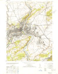 1953 Easton1953 Print · USGSThe industrial core of the Delaware and Lehigh forks comes to life in this mid-century survey of the Pennsylvania-New Jersey border. Genealogists and historians can trace the footprint of Lafayette College, the path of the Morris Canal, and local landmarks like Hays Cemetery.2 unique versions available
 - 1953 Map of Riegelsville
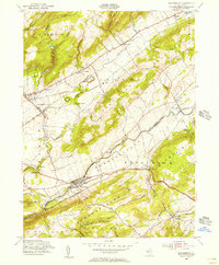
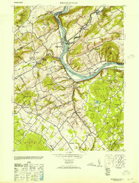 1953 Riegelsville1953 Print · USGSThe Delaware River valley straddles the Pennsylvania and New Jersey border in the early fifties, showcasing a landscape of industrial river towns and upland farms. Genealogists can locate family landmarks from Durham Furnace to Riegelsville, including St Lukes Church and the Stouts School.2 unique versions available
 - 1953 Map of Frenchtown
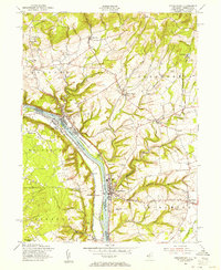
 1953 Frenchtown1953 Print · USGSThe Delaware River valley thrived mid-century with active rail lines and riverside industry connecting New Jersey and Pennsylvania communities. Genealogists can trace family roots through several rural schoolhouses and landmarks like Alexandria Cemetery, Lodge Hall, and Milford.
 - 1955 Map of Frenchtown, 1956 Print
 1955 Frenchtown1956 Print · USGSThe Delaware River valley thrived as a corridor for rail and commerce in the mid-1950s, bridging New Jersey and Pennsylvania communities. Researchers can trace family roots through riverside settlements like Frenchtown and Milford, or locate rural landmarks such as Milford Union Ch and Alexandria Cem.5 unique versions available
 - 1955 Map of Bloomsbury, 1956 Print
 1955 Bloomsbury1956 Print · USGSThe Musconetcong Valley in the mid-1950s reveals a landscape where historic industrial infrastructure meets post-war growth. Genealogists and historians can trace family-named roads and rural hamlets like Stewartsville, Asbury, and the path of the old Morris Canal.4 unique versions available
 - 1956 Map of Newark
 1956 Newark1956 Print · USGSThe industrial heart of the Mid-Atlantic is captured here at the dawn of the highway era, tracing the dense corridors between Newark and Philadelphia. Genealogists and local historians can map the rail networks of the Reading RR or locate mid-century military life at Fort Dix Military Reservation.2 unique versions available
 - 1956 Map of Riegelsville, 1958 Print
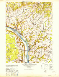
 1956 Riegelsville1958 Print · USGSThe Delaware River valley in the mid-fifties reveals a landscape of ridge-top farms and industrial remnants near the New Jersey border. Researchers can locate family landmarks like the Durham Union Church, Township School, and the site of the Durham Furnace.6 unique versions available
 - 1956 Map of Easton, 1958 Print
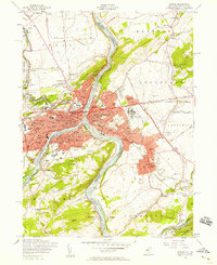 1956 Easton1958 Print · USGSEaston and Phillipsburg stand as twin industrial hubs at the Delaware and Lehigh confluence in the mid-fifties. Genealogists and historians can trace the footprint of Lafayette College, search for family sites at Arndts & Messinger Cem, or follow the many rail lines like the Pennsylvania RR.7 unique versions available
 - 1957 Map of Newark
 1957 Newark1957 Print · USGSThe industrial and military heart of the Mid-Atlantic is mapped during its post-war suburban boom. Genealogists and historians can trace the intricate rail corridors of the Reading Railroad and locate key landmarks from Princeton University to Fort Hancock.
End of results
Showing maps 1-9 of 9
Top cities near Holland Township
- Bethlehem historical maps
- Easton historical maps
- Raritan Township historical maps
- Buckingham Township historical maps
- Hopewell Township historical maps
- Phillipsburg historical maps
See more
Top neighborhoods of Holland Township
- Spring Mills historical maps
- Mount Joy historical maps
- Riegel Ridge historical maps
- Amsterdam historical maps
Frequently asked questions
- What are the different types of historical maps available for Holland Township?
- What is the oldest map of Holland Township?
- Where can I purchase historical maps of Holland Township for my home or office?
- Where can I download high-res historical maps of Holland Township?
- Are there historical topographic maps available for Holland Township?
- Is there historical aerial imagery available for Holland Township?
- Where are historical maps of Holland Township sourced from?