1940s Maps of Lawrence Township, New Jersey
Explore 10 historic maps of Lawrence Township from the 1940s. These maps offer a rare glimpse into what life looked like during the 1940s — showing old roads, neighborhoods, homes, and landmarks that have changed or disappeared over time.
Whether you're researching your family's past, planning a metal detecting trip, or studying how Lawrence Township's landscape evolved across the 1940s, these high-resolution maps are a powerful tool for exploring the history of this region.
- Focus on a specific era: All maps on this page are from the 1940s, giving you a focused view of this time period.
- See what’s changed: Compare century-old streets, trails, and buildings to today's modern landscape using overlays and satellite layers.
- Research with precision: Use these maps for genealogy, historical research, land use analysis, or educational projects.
- View, download, or print: Maps are fully viewable online in high resolution, and can be downloaded or printed for your own records.
Start exploring Lawrence Township's history through authentic maps from the 1940s. This is your window into the past.
Lawrence Township, NJ maps
(10)- 1942 Map of Burlington
 1942 Burlington1942 Print · USGSThe Delaware River valley thrived at the start of the 1940s as a hub of heavy rail and river commerce. Genealogists and local historians can trace family-named sites and old transit points like Dunks Ferry, Borton Landing, and Neshaminy Falls.
 - 1943 Map of Pennington
 1943 Pennington1943 Print · USGSThe Delaware River borderlands between New Jersey and Pennsylvania are captured here during the Second World War. Genealogists and historians can trace riverside landmarks like Scudders Falls, old family hamlets like Bear Tavern, and the early footprint of Mercer Airport.
 - 1944 Map of Trenton West, 1950 Print
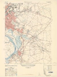
 1944 Trenton West1950 Print · USGSThe Delaware River corridor near Trenton and Morrisville is captured here at the height of its mid-century rail and industrial era. Genealogists and historians can trace old property boundaries and landmarks from Fallsington to the landmark Wm Trent House 1719.
 - 1944 Map of Newark, 1971 Print
 1944 Newark1971 Print · USGSThe industrial corridor from Philadelphia to New York was in a period of massive transition during the mid-forties. Genealogists and researchers can trace the rail lines of the Lehigh Valley RR, locate military installations like Picatinny Arsenal, and explore the early sprawl near Levittown.5 unique versions available
 - 1946 Map of Princeton, 1952 Print
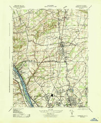
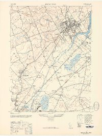 1946 Princeton1952 Print · USGSCentral New Jersey at the start of the post-war era reveals a landscape defined by its prestigious institutions and expanding rail corridors. Genealogists can locate family landmarks like Rosedale Chapel or trace the early grounds of the Lawrenceville School.
 - 1947 Map of Trenton West
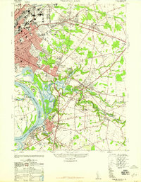
 1947 Trenton West1947 Print · USGSThe Delaware River corridor near Trenton and Morrisville was a hive of rail and river activity just after the war. Genealogists and local historians can trace the foundations of Fallsington, locate the Wm Trent House 1719, and follow the Reading Company line through Woodside.
 - 1947 Map of Trenton East
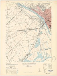
 1947 Trenton East1947 Print · USGSMercer County and the Delaware River waterfront are captured here just after the war as industrial hubs and suburban neighborhoods began to expand. Genealogists and historians can trace the foundations of Warner Village, locate the Bordentown Cemetery, or find the Pennsylvania Maritime Academy along the riverbank.
 - 1948 Map of Trenton East, 1949 Print
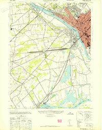
 1948 Trenton East1949 Print · USGSMercer County and its surroundings are documented here in the late 1940s as suburban expansion began to reshape the landscape. Local historians can trace the development of Warner Village and Hamilton Square or locate landmarks like the Pennsylvania Maritime Academy and Bordentown Cemetery.
 - 1948 Map of Bordentown, 1954 Print
 1948 Bordentown1954 Print · USGSCentral New Jersey stands at the crossroads of military expansion and early highway development in the years following the war. Genealogists and historians can trace the rural layouts of Bordentown and New Egypt or locate landmarks like Arneys Mount and the Pa Maritime Academy.2 unique versions available
 - 1949 Map of Newark
 1949 Newark1949 Print · USGSThe industrial corridor between Philadelphia and New York comes alive in this post-war survey. Genealogists and historians can trace the massive rail networks of the Reading Railroad and locate major installations like Fort Dix or Picatinny Arsenal.2 unique versions available
End of results
Showing maps 1-10 of 10
Top cities near Lawrence Township
- Hamilton Township historical maps
- Trenton historical maps
- Franklin Township historical maps
- Bensalem Township historical maps
- Levittown historical maps
- Piscataway Township historical maps
See more
Top neighborhoods of Lawrence Township
- Port Mercer historical maps
- Princessville historical maps
- Sturwood Hamlet historical maps
- Rosedale historical maps
- Harneys Corner historical maps
- Lawrenceville historical maps
See more
Frequently asked questions
- What are the different types of historical maps available for Lawrence Township?
- What is the oldest map of Lawrence Township?
- Where can I purchase historical maps of Lawrence Township for my home or office?
- Where can I download high-res historical maps of Lawrence Township?
- Are there historical topographic maps available for Lawrence Township?
- Is there historical aerial imagery available for Lawrence Township?
- Where are historical maps of Lawrence Township sourced from?