1990s Maps of West Windsor, New Jersey
Explore 4 historic maps of West Windsor from the 1990s. These maps offer a rare glimpse into what life looked like during the 1990s — showing old roads, neighborhoods, homes, and landmarks that have changed or disappeared over time.
Whether you're researching your family's past, planning a metal detecting trip, or studying how West Windsor's landscape evolved across the 1990s, these high-resolution maps are a powerful tool for exploring the history of this region.
- Focus on a specific era: All maps on this page are from the 1990s, giving you a focused view of this time period.
- See what’s changed: Compare century-old streets, trails, and buildings to today's modern landscape using overlays and satellite layers.
- Research with precision: Use these maps for genealogy, historical research, land use analysis, or educational projects.
- View, download, or print: Maps are fully viewable online in high resolution, and can be downloaded or printed for your own records.
Start exploring West Windsor's history through authentic maps from the 1990s. This is your window into the past.
West Windsor, NJ maps
(4)- 1995 Map of Allentown, 1999 Print
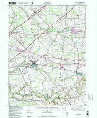 1995 Allentown1999 Print · USGSCentral New Jersey's transition from rural mill towns to a modern suburban landscape is clear in this late-century survey. Genealogists and historians can trace family roots through St Johns Ch, find former hubs like Davis Station, or locate old mill sites at Walnford and Kirbys Mills.
 - 1995 Map of Hightstown, 2000 Print
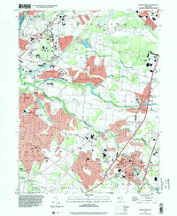 1995 Hightstown2000 Print · USGSIn the mid-nineties, this part of Central Jersey reflects a period of intense suburban growth along the New Jersey Turnpike. Genealogists and historians can trace the development of local institutions from Peddie Sch to historic crossroads like Grovers Mill and Dutch Neck.
 - 1995 Map of Trenton East, 2000 Print
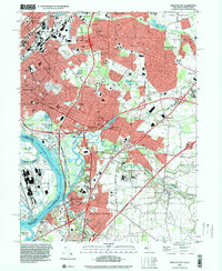 1995 Trenton East2000 Print · USGSMercer County communities east of the state capital are shown in the mid-nineties as the corridor between Trenton and Bordentown continued to develop. Researchers can trace local landmarks like Greenwood Cemetery, the State Industrial School, and Hamilton Square.
 - 1995 Map of Princeton, 2000 Print
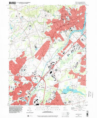 1995 Princeton2000 Print · USGSMid-century academic life and suburban growth converge in this mid-1990s look at the Mercer County corridor. Local historians can trace the legacy of educational landmarks like Princeton University or explore the canal-side history of Port Mercer and Penns Neck.
End of results
Showing maps 1-4 of 4
Top cities near West Windsor
- Edison historical maps
- Hamilton Township historical maps
- Trenton historical maps
- Franklin Township historical maps
- Jackson Township historical maps
- Levittown historical maps
See more
Top neighborhoods of West Windsor
- Edinburg Park historical maps
- Grovers Mill historical maps
- Old Mill Farms historical maps
- Edinburg historical maps
- Princeton Ivy East historical maps
- Princeton Junction historical maps
See more
Frequently asked questions
- What are the different types of historical maps available for West Windsor?
- What is the oldest map of West Windsor?
- Where can I purchase historical maps of West Windsor for my home or office?
- Where can I download high-res historical maps of West Windsor?
- Are there historical topographic maps available for West Windsor?
- Is there historical aerial imagery available for West Windsor?
- Where are historical maps of West Windsor sourced from?