1940s Maps of Atlantic Highlands, New Jersey
Explore 5 historic maps of Atlantic Highlands from the 1940s. These maps offer a rare glimpse into what life looked like during the 1940s — showing old roads, neighborhoods, homes, and landmarks that have changed or disappeared over time.
Whether you're researching your family's past, planning a metal detecting trip, or studying how Atlantic Highlands's landscape evolved across the 1940s, these high-resolution maps are a powerful tool for exploring the history of this region.
- Focus on a specific era: All maps on this page are from the 1940s, giving you a focused view of this time period.
- See what’s changed: Compare century-old streets, trails, and buildings to today's modern landscape using overlays and satellite layers.
- Research with precision: Use these maps for genealogy, historical research, land use analysis, or educational projects.
- View, download, or print: Maps are fully viewable online in high resolution, and can be downloaded or printed for your own records.
Start exploring Atlantic Highlands's history through authentic maps from the 1940s. This is your window into the past.
Atlantic Highlands, NJ maps
(5)- 1944 Map of Newark, 1971 Print
 1944 Newark1971 Print · USGSThe industrial corridor from Philadelphia to New York was in a period of massive transition during the mid-forties. Genealogists and researchers can trace the rail lines of the Lehigh Valley RR, locate military installations like Picatinny Arsenal, and explore the early sprawl near Levittown.5 unique versions available
 - 1947 Map of Sandy Hook, 1950 Print
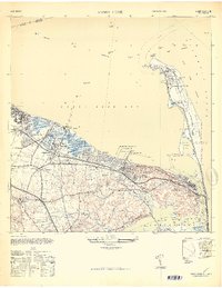 1947 Sandy Hook1950 Print · USGSMonmouth County's coastline comes alive in this late 1940s survey of the iconic barrier spit and its neighboring mainland harbor towns. Genealogists and historians can trace family properties like the Elgan Rauch Farm or find lost landmarks such as the Roseland Hotel and Belford Sta.
 - 1947 Map of Sandy Hook, 1950 Print
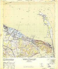 1947 Sandy Hook1950 Print · USGSThe Monmouth County coastline at the end of the 1940s shows a landscape of military defense and busy maritime piers. Genealogists can trace family landmarks like the N J Strauss Farm or locate old community centers like St Clements Ch and Harmony Cem.
 - 1949 Map of Newark
 1949 Newark1949 Print · USGSThe industrial corridor between Philadelphia and New York comes alive in this post-war survey. Genealogists and historians can trace the massive rail networks of the Reading Railroad and locate major installations like Fort Dix or Picatinny Arsenal.2 unique versions available
 - 1949 Map of New York, 1951 Print
 1949 New York1951 Print · USGSLong Island and its surrounding waters are documented here in the late 1940s, just as the postwar suburban boom began to transform the region. Genealogists and historians can trace the early layouts of Idlewild Airport, Mitchell Field, and the established routes of the Long Island RR.
End of results
Showing maps 1-5 of 5
Top cities near Atlantic Highlands
- New York historical maps
- Elizabeth historical maps
- Woodbridge Township historical maps
- Middletown Township historical maps
- Old Bridge Township historical maps
- Bayonne historical maps
See more
Top neighborhoods of Atlantic Highlands
Frequently asked questions
- What are the different types of historical maps available for Atlantic Highlands?
- What is the oldest map of Atlantic Highlands?
- Where can I purchase historical maps of Atlantic Highlands for my home or office?
- Where can I download high-res historical maps of Atlantic Highlands?
- Are there historical topographic maps available for Atlantic Highlands?
- Is there historical aerial imagery available for Atlantic Highlands?
- Where are historical maps of Atlantic Highlands sourced from?