1950s Maps of Howell Township, New Jersey
Explore 7 historic maps of Howell Township from the 1950s. These maps offer a rare glimpse into what life looked like during the 1950s — showing old roads, neighborhoods, homes, and landmarks that have changed or disappeared over time.
Whether you're researching your family's past, planning a metal detecting trip, or studying how Howell Township's landscape evolved across the 1950s, these high-resolution maps are a powerful tool for exploring the history of this region.
- Focus on a specific era: All maps on this page are from the 1950s, giving you a focused view of this time period.
- See what’s changed: Compare century-old streets, trails, and buildings to today's modern landscape using overlays and satellite layers.
- Research with precision: Use these maps for genealogy, historical research, land use analysis, or educational projects.
- View, download, or print: Maps are fully viewable online in high resolution, and can be downloaded or printed for your own records.
Start exploring Howell Township's history through authentic maps from the 1950s. This is your window into the past.
Howell Township, NJ maps
(7)- 1954 Map of Farmingdale
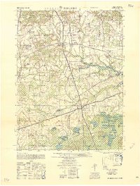
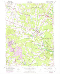 1954 Farmingdale1954 Print · USGSMonmouth County during the mid-fifties shows a landscape of military reservations and expanding suburban residential tracts. Trace family history and local landmarks through the Southard Ch, the Drive-in Theater, and the sprawling Earle Ammunition Depot.6 unique versions available
 - 1954 Map of Marlboro, 1956 Print
 1954 Marlboro1956 Print · USGSMonmouth County in the mid-fifties is captured here as a landscape of agricultural tradition meeting modern infrastructure. Genealogists and historians can trace family locations near Colts Neck, the Marlboro State Hospital, and smaller hamlets like Bradevelt or Scobeyville.5 unique versions available
 - 1954 Map of Lakewood, 1956 Print
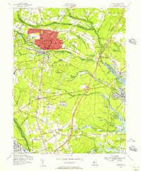 1954 Lakewood1956 Print · USGSMid-century Ocean County is captured during a period of growth, centered on the historic resort community of Lakewood and its surrounding townships. Researchers can trace family sites and local institutions through landmarks like Georgian Court College, Seven Stars, and the Mt Sinai Cem.3 unique versions available
 - 1956 Map of Newark
 1956 Newark1956 Print · USGSThe industrial heart of the Mid-Atlantic is captured here at the dawn of the highway era, tracing the dense corridors between Newark and Philadelphia. Genealogists and local historians can map the rail networks of the Reading RR or locate mid-century military life at Fort Dix Military Reservation.2 unique versions available
 - 1957 Map of Newark
 1957 Newark1957 Print · USGSThe industrial and military heart of the Mid-Atlantic is mapped during its post-war suburban boom. Genealogists and historians can trace the intricate rail corridors of the Reading Railroad and locate key landmarks from Princeton University to Fort Hancock.
 - 1957 Map of Adelphia, 1961 Print
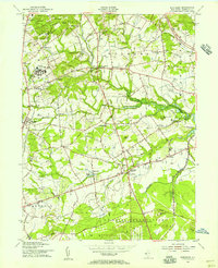
 1957 Adelphia1961 Print · USGSMid-century Monmouth and Ocean Counties are captured here during a period of transition for their rural mill towns and specialized farms. Genealogists and local historians can trace the foundations of Adelphia and West Freehold, or locate old water-powered sites like Wyckoff Mills and Jacksons Mills.5 unique versions available
 - 1958 Map of Marlboro
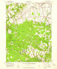
 1958 Marlboro1958 Print · USGSMonmouth County's interior is captured here in the late fifties, showing a landscape of institutional campuses, family farms, and cider spirits. Researchers can trace local heritage through landmarks like Marlboro State Hospital for the Insane, Lairds Distillery, and the Collier Foundation School for Wayward Girls.
End of results
Showing maps 1-7 of 7
Top cities near Howell Township
- Toms River historical maps
- Lakewood Township historical maps
- Brick Township historical maps
- Middletown Township historical maps
- Old Bridge Township historical maps
- Jackson Township historical maps
See more
Top neighborhoods of Howell Township
- Larrabees historical maps
- Fairfield historical maps
- Adelphia historical maps
- Ardena historical maps
- Squankum historical maps
- Matthews historical maps
See more
Frequently asked questions
- What are the different types of historical maps available for Howell Township?
- What is the oldest map of Howell Township?
- Where can I purchase historical maps of Howell Township for my home or office?
- Where can I download high-res historical maps of Howell Township?
- Are there historical topographic maps available for Howell Township?
- Is there historical aerial imagery available for Howell Township?
- Where are historical maps of Howell Township sourced from?