1940s Maps of Millstone Township, New Jersey
Explore 11 historic maps of Millstone Township from the 1940s. These maps offer a rare glimpse into what life looked like during the 1940s — showing old roads, neighborhoods, homes, and landmarks that have changed or disappeared over time.
Whether you're researching your family's past, planning a metal detecting trip, or studying how Millstone Township's landscape evolved across the 1940s, these high-resolution maps are a powerful tool for exploring the history of this region.
- Focus on a specific era: All maps on this page are from the 1940s, giving you a focused view of this time period.
- See what’s changed: Compare century-old streets, trails, and buildings to today's modern landscape using overlays and satellite layers.
- Research with precision: Use these maps for genealogy, historical research, land use analysis, or educational projects.
- View, download, or print: Maps are fully viewable online in high resolution, and can be downloaded or printed for your own records.
Start exploring Millstone Township's history through authentic maps from the 1940s. This is your window into the past.
Millstone Township, NJ maps
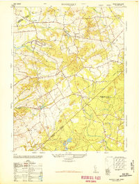
(11)- 1942 Map of Jamesburg
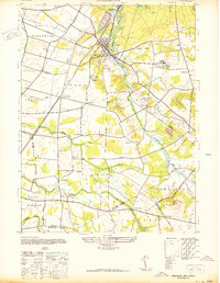 1942 Jamesburg1942 Print · USGSCentral New Jersey during the early 1940s reveals a network of rail-dependent boroughs and rural townships. Genealogists and historians can trace family locations near Old Church, identify the grounds of the Jamesburg State Reformatory, and locate vanished points like Bergen Mills.
 - 1944 Map of Jersey Homesteads
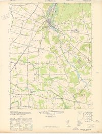
 1944 Jersey Homesteads1944 Print · USGSMonmouth and Ocean counties appear here during the mid-forties, capturing a landscape of rural hamlets and small mills. Researchers can trace the New Deal-era Jersey Homesteads and find ancestral sites like Francis Mills, Carrs Tavern, and Perrineville.
 - 1944 Map of Newark, 1971 Print
 1944 Newark1971 Print · USGSThe industrial corridor from Philadelphia to New York was in a period of massive transition during the mid-forties. Genealogists and researchers can trace the rail lines of the Lehigh Valley RR, locate military installations like Picatinny Arsenal, and explore the early sprawl near Levittown.5 unique versions available
 - 1947 Map of Roosevelt
 1947 Roosevelt1947 Print · USGSCentral New Jersey's rural interior is captured here just after the war, showing the unique intersection of Monmouth, Mercer, and Ocean counties. Genealogists and local historians can trace family-named sites like Carrs Tavern, Holmeson, and the extensive Cranberry bogs near Prospertown.2 unique versions available
 - 1947 Map of Jamesburg
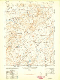
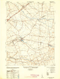
 1947 Jamesburg1947 Print · USGSMiddlesex County's rail-connected towns and crossroads settlements are captured here just after the war. Local researchers can trace the grounds of the Jamesburg State Reformatory, locate the old Monroe Sch, and explore vanished stop points like Matchaponix and Bergen Mills.
 - 1947 Map of Adelphia
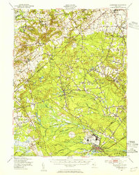
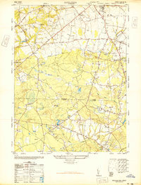 1947 Adelphia1947 Print · USGSMonmouth and Ocean Counties are captured here in the late 1940s, showing a landscape defined by industry and agriculture before major suburbanization. Trace the footprints of early mill sites like Jacksons Mills and Wyckoff Mills, or the extensive cranberry bogs along the Manasquan River.2 unique versions available
 - 1948 Map of Roosevelt
 1948 Roosevelt1948 Print · USGSMonmouth County rural life is captured in the late 1940s, showing the early days of the Roosevelt colony and established hamlets. Genealogists can trace family landmarks and crossroads like Stone Tavern, Clarksburg, and the numerous Cranberry bogs near Prospertown.
 - 1948 Map of Allentown
 1948 Allentown1948 Print · USGSMonmouth and Mercer counties meet here in the late 1940s, showing a landscape of established townships and crossroad settlements. Genealogists and local historians can trace family-named sites like Walnford, Nelsonville, and the East Windsor Cemetery.2 unique versions available
 - 1948 Map of Lakehurst, 1954 Print
 1948 Lakehurst1954 Print · USGSPost-war central New Jersey comes to life here, showing the rural landscapes of Ocean and Monmouth counties before major suburbanization. Trace the footprints of the U S Naval Air Station and historic mill towns like Jacksons Mills and Cassville.2 unique versions available
 - 1948 Map of Bordentown, 1954 Print
 1948 Bordentown1954 Print · USGSCentral New Jersey stands at the crossroads of military expansion and early highway development in the years following the war. Genealogists and historians can trace the rural layouts of Bordentown and New Egypt or locate landmarks like Arneys Mount and the Pa Maritime Academy.2 unique versions available
 - 1949 Map of Newark
 1949 Newark1949 Print · USGSThe industrial corridor between Philadelphia and New York comes alive in this post-war survey. Genealogists and historians can trace the massive rail networks of the Reading Railroad and locate major installations like Fort Dix or Picatinny Arsenal.2 unique versions available
End of results
Showing maps 1-11 of 11
Top cities near Millstone Township
- Toms River historical maps
- Lakewood Township historical maps
- Hamilton Township historical maps
- Franklin Township historical maps
- Old Bridge Township historical maps
- Howell Township historical maps
See more
Top neighborhoods of Millstone Township
- Clarksburg historical maps
- Ely historical maps
- Perrineville historical maps
- Charleston Springs historical maps
- Elys Corner historical maps
- Fair Play historical maps
See more
Frequently asked questions
- What are the different types of historical maps available for Millstone Township?
- What is the oldest map of Millstone Township?
- Where can I purchase historical maps of Millstone Township for my home or office?
- Where can I download high-res historical maps of Millstone Township?
- Are there historical topographic maps available for Millstone Township?
- Is there historical aerial imagery available for Millstone Township?
- Where are historical maps of Millstone Township sourced from?