1940s Maps of Barnegat Township, New Jersey
Explore 8 historic maps of Barnegat Township from the 1940s. These maps offer a rare glimpse into what life looked like during the 1940s — showing old roads, neighborhoods, homes, and landmarks that have changed or disappeared over time.
Whether you're researching your family's past, planning a metal detecting trip, or studying how Barnegat Township's landscape evolved across the 1940s, these high-resolution maps are a powerful tool for exploring the history of this region.
- Focus on a specific era: All maps on this page are from the 1940s, giving you a focused view of this time period.
- See what’s changed: Compare century-old streets, trails, and buildings to today's modern landscape using overlays and satellite layers.
- Research with precision: Use these maps for genealogy, historical research, land use analysis, or educational projects.
- View, download, or print: Maps are fully viewable online in high resolution, and can be downloaded or printed for your own records.
Start exploring Barnegat Township's history through authentic maps from the 1940s. This is your window into the past.
Barnegat Township, NJ maps
(8)- 1941 Map of Toms River
 1941 Toms River1941 Print · USGSCoastal New Jersey's riverfronts and barrier islands are captured here just before the mid-century boom. Trace historic family sites and early infrastructure at Double Trouble, Murray Grove Cemetery, and the Pinewald Golf Course.2 unique versions available
 - 1941 Map of Long Beach
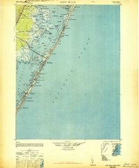
 1941 Long Beach1941 Print · USGSLong Beach Island and the Jersey Shore appear here just before the mid-century, showing a string of coastal villages linked by the Pennsylvania Railroad. Genealogists and historians can trace property near Long Beach Township Hall or explore early bayside landmarks like Ship Bottom and Harvey Cedars.
 - 1942 Map of Whiting
 1942 Whiting1942 Print · USGSThe Jersey Pine Barrens are captured here during the early years of the war, showing the region's transition between industry and military use. Genealogists and historians can trace old settlements like Woodmansie, early aviation at Coyle Field, and the rail junction at Whiting.2 unique versions available
 - 1942 Map of Tuckerton
 1942 Tuckerton1942 Print · USGSThe Jersey Shore and Pine Barrens meet here just as the coastal infrastructure was maturing before mid-century. Researchers can trace the layout of Tuckerton, locate the old Stafford Forge, and explore the maze of sedges in Little Egg Harbor.2 unique versions available
 - 1946 Map of Wilmington, 1948 Print
 1946 Wilmington1948 Print · USGSThe Delaware Valley and Jersey Shore emerge in this mid-century portrait of a region defined by river commerce and seaside growth. Genealogists and historians can trace the rail networks of the Pennsylvania Railroad, locate early airfields like Dover Airpark, and find river defenses at Fort Delaware.2 unique versions available
 - 1948 Map of Long Beach
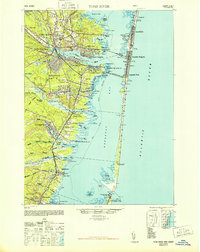
 1948 Long Beach1948 Print · USGSLong Beach Island is shown in the late 1940s as a series of growing seaside communities and strategic maritime stations. Researchers can trace the early layout of Surf City, Beach Haven, and the Harvey Cedars CG 115 coast guard facility.3 unique versions available
 - 1948 Map of Toms River
 1948 Toms River1948 Print · USGSThe Jersey Shore's mid-century landscape is preserved here, from the mainland settlements of Toms River to the narrow barrier of Island Beach. Genealogists can trace family landmarks like the Friends Meeting Cemetery and Murray Grove Cemetery as the coastal rail lines linked the bay towns.6 unique versions available
 - 1949 Map of Whiting, 1954 Print
 1949 Whiting1954 Print · USGSThe Pinelands of Ocean and Burlington Counties are shown just after the war, when rail hubs and forest reserves defined the landscape. Genealogists and historians can trace the junction at Whiting or locate smaller sites like Woodmansie, the Clay Works, and Keswick Grove.3 unique versions available
End of results
Showing maps 1-8 of 8
Top cities near Barnegat Township
- Toms River historical maps
- Manchester Township historical maps
- Berkeley Township historical maps
- Galloway Township historical maps
- Stafford Township historical maps
- Lacey Township historical maps
See more
Top neighborhoods of Barnegat Township
- Barnegat Bay historical maps
- Howardsville historical maps
- Pinewood Estates Mobile Home Park historical maps
- Brighton at Barnegat Mobile Home Park historical maps
- Barnegat Estates historical maps
- Cambridge Estates historical maps
See more
Frequently asked questions
- What are the different types of historical maps available for Barnegat Township?
- What is the oldest map of Barnegat Township?
- Where can I purchase historical maps of Barnegat Township for my home or office?
- Where can I download high-res historical maps of Barnegat Township?
- Are there historical topographic maps available for Barnegat Township?
- Is there historical aerial imagery available for Barnegat Township?
- Where are historical maps of Barnegat Township sourced from?