1950s Maps of Upper Pittsgrove Township, New Jersey
Explore 8 historic maps of Upper Pittsgrove Township from the 1950s. These maps offer a rare glimpse into what life looked like during the 1950s — showing old roads, neighborhoods, homes, and landmarks that have changed or disappeared over time.
Whether you're researching your family's past, planning a metal detecting trip, or studying how Upper Pittsgrove Township's landscape evolved across the 1950s, these high-resolution maps are a powerful tool for exploring the history of this region.
- Focus on a specific era: All maps on this page are from the 1950s, giving you a focused view of this time period.
- See what’s changed: Compare century-old streets, trails, and buildings to today's modern landscape using overlays and satellite layers.
- Research with precision: Use these maps for genealogy, historical research, land use analysis, or educational projects.
- View, download, or print: Maps are fully viewable online in high resolution, and can be downloaded or printed for your own records.
Start exploring Upper Pittsgrove Township's history through authentic maps from the 1950s. This is your window into the past.
Upper Pittsgrove Township, NJ maps
(8)- 1953 Map of Newfield, 1954 Print
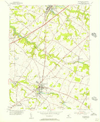
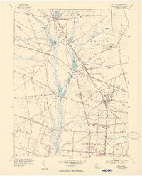 1953 Newfield1954 Print · USGSSouthern New Jersey's transition from agricultural hinterland to rail-connected boroughs is captured here in the early fifties. Genealogists and researchers can trace family roots through Alliance, Brotmanville, and landmarks like Rose Hill Cem and Zion Ch.7 unique versions available
 - 1953 Map of Pitman West, 1954 Print
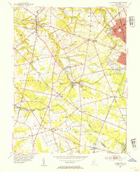 1953 Pitman West1954 Print · USGSSouth Jersey's farming heartland and growing boroughs are captured here in the early fifties. Genealogists can trace family roots through Mullica Hill, Aura, and Hardingville, or locate historic sites like Siloam Ch and Richwood Academy.2 unique versions available
 - 1953 Map of Elmer, 1954 Print
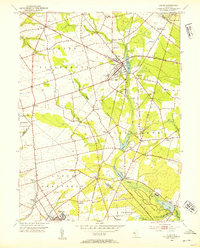 1953 Elmer1954 Print · USGSSalem County’s agricultural and rail-dependent heartland is captured in the early fifties during a peak of rural development. Researchers can trace family roots through the Monroeville Synagogue, Chestnut Grove Cem, and the specialized settlements at Seabrook and Deerfield Street.5 unique versions available
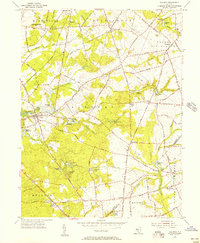
 - 1955 Map of Wilmington
 1955 Wilmington1955 Print · USGSThe Delaware Valley and Jersey Shore are seen here during the mid-fifties era of rapid suburban expansion and highway development. You can trace the path of the New Jersey Turnpike, locate the Fort Dix Military Reservation, or explore the rail networks of the Pennsylvania Railroad.
 - 1955 Map of Alloway, 1956 Print
 1955 Alloway1956 Print · USGSMid-century Salem County is defined here by its intricate millpond system and rural hamlets. Researchers can trace family sites at Yorktown, Daretown, and Friesburg, or locate historic landmarks like Mt Zion Cem and Fox Mill.3 unique versions available
 - 1955 Map of Woodstown, 1956 Print
 1955 Woodstown1956 Print · USGSSalem and Gloucester counties are captured here in the mid-fifties as the Jersey Turnpike begins to reshape the traditional landscape. Researchers can trace the Pennsylvania-Reading Seashore Lines through old hubs like Woodstown, Swedesboro, and the crossroads at Seven Stars.
 - 1957 Map of Wilmington
 1957 Wilmington1957 Print · USGSThe mid-Atlantic coastal plain comes alive in the mid-fifties as the New Jersey Turnpike and Garden State Parkway redefine travel. Researchers can trace the rail-to-road transition and find landmarks like Ship John Shoal Light and the Fort Dix Military Reservation.2 unique versions available
 - 1959 Map of Wilmington
 1959 Wilmington1959 Print · USGSThe Delaware Valley and Jersey Shore are seen here in the late fifties, during a period of massive suburban and highway expansion. Researchers can trace mid-century infrastructure like the N J Turnpike or locate coastal landmarks from Barnegat Bay to the Maurice River.3 unique versions available
End of results
Showing maps 1-8 of 8
Top cities near Upper Pittsgrove Township
- Vineland historical maps
- Washington Township historical maps
- Sicklerville historical maps
- Winslow Township historical maps
- Monroe Township historical maps
- Chester historical maps
See more
Top neighborhoods of Upper Pittsgrove Township
- Fox Mill historical maps
- Friendship historical maps
- Shirley historical maps
- Woods Mills historical maps
- Maple Grove historical maps
- Monroeville historical maps
See more
Frequently asked questions
- What are the different types of historical maps available for Upper Pittsgrove Township?
- What is the oldest map of Upper Pittsgrove Township?
- Where can I purchase historical maps of Upper Pittsgrove Township for my home or office?
- Where can I download high-res historical maps of Upper Pittsgrove Township?
- Are there historical topographic maps available for Upper Pittsgrove Township?
- Is there historical aerial imagery available for Upper Pittsgrove Township?
- Where are historical maps of Upper Pittsgrove Township sourced from?