1940s Maps of Hillsborough Township, New Jersey
Explore 7 historic maps of Hillsborough Township from the 1940s. These maps offer a rare glimpse into what life looked like during the 1940s — showing old roads, neighborhoods, homes, and landmarks that have changed or disappeared over time.
Whether you're researching your family's past, planning a metal detecting trip, or studying how Hillsborough Township's landscape evolved across the 1940s, these high-resolution maps are a powerful tool for exploring the history of this region.
- Focus on a specific era: All maps on this page are from the 1940s, giving you a focused view of this time period.
- See what’s changed: Compare century-old streets, trails, and buildings to today's modern landscape using overlays and satellite layers.
- Research with precision: Use these maps for genealogy, historical research, land use analysis, or educational projects.
- View, download, or print: Maps are fully viewable online in high resolution, and can be downloaded or printed for your own records.
Start exploring Hillsborough Township's history through authentic maps from the 1940s. This is your window into the past.
Hillsborough Township, NJ maps
(7)- 1943 Map of Flemington
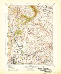 1943 Flemington1943 Print · USGSHunterdon County is shown here during the early 1940s, when the river-and-rail economy of central New Jersey was in full swing. Genealogists and local historians can trace family-named sites like Rockefellows Mills, Durling Farms, and Holcomb Mills.
 - 1943 Map of Rocky Hill
 1943 Rocky Hill1943 Print · USGSSomerset County is captured here in the early 1940s, balancing its deep-rooted farming heritage with significant wartime and state institutions. Genealogists and historians can trace family-named sites across the Sourland Mountain Hills and locate the sprawling State Village for Epileptics or the War Aid Depot.
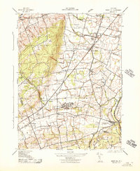
 - 1943 Map of Raritan
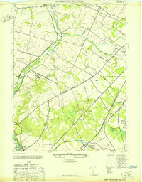
 1943 Raritan1943 Print · USGSSomerset County is shown in detail during the early 1940s, highlighting a landscape where massive private estates and wartime military depots sat alongside growing villages. Researchers can trace the industrial Raritan Factory Shaft, find the Green Knoll School, or locate the historic Woods Tavern.
 - 1944 Map of Newark, 1971 Print
 1944 Newark1971 Print · USGSThe industrial corridor from Philadelphia to New York was in a period of massive transition during the mid-forties. Genealogists and researchers can trace the rail lines of the Lehigh Valley RR, locate military installations like Picatinny Arsenal, and explore the early sprawl near Levittown.5 unique versions available
 - 1947 Map of Bound Brook
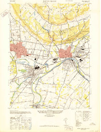 1947 Bound Brook1947 Print · USGSSomerset County is shown at its post-war industrial peak when the confluence of the Raritan and Millstone rivers was a bustling rail hub. Genealogists and historians can trace the foundations of Manville, identify the expansive Duke Estate, or locate family sites near Serca Pana Jezusa Cem.
 - 1947 Map of Monmouth Junction
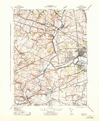
 1947 Monmouth Junction1947 Print · USGSCentral New Jersey in the late 1940s reveals a landscape of river-side canal towns and bustling rail hubs. Genealogists and local historians can trace the branching lines at Monmouth Junction and locate Washingtons Headquarters near Kingston.
 - 1949 Map of Newark
 1949 Newark1949 Print · USGSThe industrial corridor between Philadelphia and New York comes alive in this post-war survey. Genealogists and historians can trace the massive rail networks of the Reading Railroad and locate major installations like Fort Dix or Picatinny Arsenal.2 unique versions available
End of results
Showing maps 1-7 of 7
Top cities near Hillsborough Township
- Franklin Township historical maps
- Piscataway Township historical maps
- New Brunswick historical maps
- Monroe Township historical maps
- East Brunswick Township historical maps
- Plainfield historical maps
See more
Top neighborhoods of Hillsborough Township
- Bloomingdale historical maps
- Pleasantview historical maps
- Royce Valley historical maps
- Woods Tavern historical maps
- Zion historical maps
- Flagtown historical maps
See more
Frequently asked questions
- What are the different types of historical maps available for Hillsborough Township?
- What is the oldest map of Hillsborough Township?
- Where can I purchase historical maps of Hillsborough Township for my home or office?
- Where can I download high-res historical maps of Hillsborough Township?
- Are there historical topographic maps available for Hillsborough Township?
- Is there historical aerial imagery available for Hillsborough Township?
- Where are historical maps of Hillsborough Township sourced from?