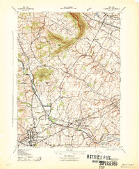
1943 Map of Flemington
USGS Topo · Published 1943About this map
The South Branch Raritan River winds through this central New Jersey landscape during the early 1940s, anchoring a network of small settlements and industrial outposts. The town of Flemington serves as a primary hub, showing concentrated development near the Foran Foundry and the local Court House. This era captures a transition where traditional agricultural industry still persists alongside growing transit lines, evidenced by active milling sites like Stover Mills, Holcomb Mills, and Rockefellows Mills scattered along the riverbanks and its tributaries.
Find a feature on this map
45 named features on this map. Tap any name to fly to it.
Don’t see what you’re looking for? This feature index may not catch every label — zoom into the map to look around manually.
Map Details
Editions of this 1943 Flemington Map
This is the sole edition of this map. No revisions or reprints were ever made.
Other maps of this area

1888 · Princeton
USGS Topo · 1:62,500

1890 · High Bridge
USGS Topo · 1:62,500

1890 · Lambertville
USGS Topo · 1:62,500

1891 · Somerville
USGS Topo · 1:62,500

1891 · Lambertville
USGS Topo · 1:62,500

1893 · Somerville
USGS Topo · 1:62,500

1894 · Princeton
USGS Topo · 1:62,500

1894 · Lambertville
USGS Topo · 1:62,500

1898 · High Bridge
USGS Topo · 1:62,500

1898 · Somerville
USGS Topo · 1:62,500