Old Maps of Montague Township, New Jersey for Genealogy
Trace your family roots with 46 historic maps of Montague Township. These high-res maps reveal old neighborhoods, homesites, landmarks, and streets — helping you uncover where your ancestors lived and how the area evolved over time.
- Explore historic neighborhoods: Identify where your relatives may have lived in the 1800s or 1900s.
- Compare maps over time: Trace the changes in streets, buildings, and landmarks for multi-generational research.
- Perfect for genealogy & ancestry research: Used by family historians and researchers to map out lineage and migration.
These maps are an incredible resource for exploring your personal connection to Montague Township's past.
Montague Township, NJ maps
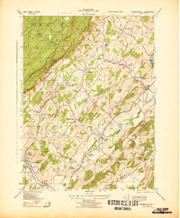
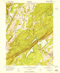
(46)- 1888 Map of Franklin
 1888 Franklin1888 Print · USGSSussex County was a thriving hub of iron mining and rail commerce in the late nineteenth century. Genealogists and historians can trace the early industrial layout of Franklin Furnace, the remote Ogden Mine, and rural junctions like Branchville Junction.
 - 1891 Map of Wallpack
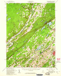
 1891 Wallpack1891 Print · USGSThe Delaware River valley and Kittatinny Mountain ridges define this late nineteenth-century borderland between Pennsylvania and New Jersey. Genealogists can locate historic river crossings like Dingmans Ferry and trace early rail lines including the Paulins Kill Railroad.
 - 1893 Map of Wallpack
 1893 Wallpack1893 Print · USGSThe Delaware River valley and Kittatinny Mountain are captured here during the late nineteenth century, showing a landscape defined by ferries and early rail. You can trace old river crossings like Smiths Ferry or locate the rural post office at Peters Valley Bevans P.O. and the rail stop at Emmons Station.8 unique versions available
 - 1894 Map of Franklin
 1894 Franklin1894 Print · USGSSussex County was a thriving industrial hub in the late nineteenth century, driven by the iron and zinc deposits of the Highlands. Genealogists and historians can trace the rail-to-mine connections between Franklin Furnace, Ogden Mine, and Deckertown.
 - 1897 Map of Franklin
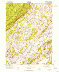
 1897 Franklin1897 Print · USGSSussex County’s industrial and agricultural heartlands are captured in the late 1890s, centered on the vital mining district and its complex rail network. Genealogists and historians can trace the footprint of early iron and zinc works at Franklin Furnace or locate family homesteads near Branchville and Papakating.
 - 1903 Map of Franklin Furnace
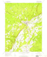
 1903 Franklin Furnace1903 Print · USGSSussex County at the turn of the century is a landscape shaped by iron mining and a bustling rail network. Genealogists and historians can trace the early industrial roots of Franklin Furnace, locate rural landmarks like North Church, and follow the path of the Lehigh and Hudson River Railroad.4 unique versions available
 - 1906 Map of Port Jervis, 1956 Print
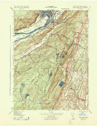
 1906 Port Jervis1956 Print · USGSPort Jervis sits at the confluence of the Delaware and Neversink rivers during the height of the railroad era. Genealogists and local historians can trace the paths of the Erie RR, find vanished hamlets like Logtown, and locate the Old Bolton Basin along the river.
 - 1908 Map of Port Jervis
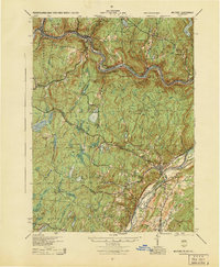
 1908 Port Jervis1908 Print · USGSThe tri-state border region comes alive at the start of the twentieth century, focused on the rail-and-river hub of Port Jervis. Genealogists and historians can trace family locations across Matamoras, Unionville, and Westtown, or locate landmarks like Tristate Rock and Old Bolton Basin.4 unique versions available
 - 1913 Map of Milford, 1958 Print
 1913 Milford1958 Print · USGSBefore the Tri-State area was suburbanized, this early twentieth-century survey captures the rugged river economy of the Delaware valley. Genealogists can trace family roots at McCartys Corner or locate vanished rural schoolhouses like the McCain School and Woodtown School.
 - 1915 Map of Milford
 1915 Milford1915 Print · USGSThe Delaware River valley at the tri-state border comes alive in this pre-war survey, capturing a world of riverside rail stations and remote mountain schoolhouses. Genealogists can locate family landmarks like McCarthys Corner or trace rural education at the Yale Forest School and Quicktown School.7 unique versions available
 - 1943 Map of Branchville
 1943 Branchville1943 Print · USGSSussex County agriculture and rail networks are caught at a peak during the early 1940s. Genealogists can locate family landmarks like Maple Grove Farm and rural schoolhouses such as the Augusta School and Wykertown School.
 - 1943 Map of Port Jervis South
 1943 Port Jervis South1943 Print · USGSThe tri-state borderlands during the Second World War reveal a landscape of river-valley industry and upland retreats. Researchers can trace the ERIE railroad through Port Jervis or locate historical sites like the Life Magazine Camp and Tristate Bible Camp.3 unique versions available
 - 1943 Map of Culvers Gap
 1943 Culvers Gap1943 Print · USGSThe Delaware River valley and Kittatinny Mountains meet in this early 1940s survey of the New Jersey and Pennsylvania border. Researchers can trace rural life through landmarks like Dingmans Ferry, Snooks Lumber Mill, and the Sandyston School before the landscape was modernly altered.2 unique versions available
 - 1944 Map of Milford
 1944 Milford1944 Print · USGSThe tri-state Delaware River valley was a network of river-bound hamlets and upland schools during the 1940s. Genealogists and local historians can trace family locations through named sites like Dark Swamp Sch, Mongaup Sta, and Quicktown.
 - 1949 Map of Port Jervis South
 1949 Port Jervis South1949 Print · USGSThe Tri-State area at the close of the 1940s reveals a landscape of river-valley commerce and upland recreation. Genealogists and local historians can trace family-named landmarks and rural hubs like River School No 1, Duttonville, and the Life Magazine Camp.
 - 1950 Map of Scranton, 1952 Print
 1950 Scranton1952 Print · USGSMid-century Northeast Pennsylvania and the Hudson Valley come alive in this survey of the tri-state region. Genealogists and historians can trace the dense rail networks of the Erie RR and DL&W RR between industrial hubs like Scranton and Wilkes-Barre.
 - 1953 Map of Scranton
 1953 Scranton1953 Print · USGSNortheastern Pennsylvania and the Catskills are shown in great detail during the early fifties, a time when rail lines and river valleys dictated the region's growth. Genealogists and historians can trace the industrial hearts of Scranton and Wilkes-Barre or locate remote landmarks like High Point and Lake Wallenpaupack.
 - 1953 Map of Port Jervis South
 1953 Port Jervis South1953 Print · USGSThe Tri-State region comes alive in this mid-century survey of the Delaware River valley where three states meet. Genealogists and local historians can trace family-named sites and vanished institutions from Rock View House and River School No 1 to the Tristates Bible Camp.
 - 1954 Map of Branchville, 1955 Print
 1954 Branchville1955 Print · USGSSussex County's rural character is preserved in this mid-century survey of the ridges and valleys between Branchville and Libertyville. Genealogists and local historians can trace family locations near Frankford Plains Ch, Augusta, and the Sussex Airport.6 unique versions available
 - 1954 Map of Culvers Gap, 1956 Print
 1954 Culvers Gap1956 Print · USGSSussex County’s Kittatinny ridge and Delaware River shoreline appear here in the mid-fifties, during a peak era for rural youth camps and forest conservation. Genealogists and hikers can trace the Appalachian Trail, locate the Peters Valley (Bevans P O) post office, or find family-named roads like Grady Road.5 unique versions available
 - 1954 Map of Dingmans Ferry, 1960 Print
 1954 Dingmans Ferry1960 Print · USGSSussex County, New Jersey, and the Delaware River valley are captured here in the mid-fifties, just as the region’s recreation economy was at its peak. Genealogists and historians can trace the foundations of Stillwater and Branchville, or locate remote landmarks like Wallpack Center and Millbrook.2 unique versions available
 - 1958 Map of Milford, 1959 Print
 1958 Milford1959 Print · USGSThe river valley at Milford and Montague is captured here in the late fifties, showcasing a landscape of fertile islands and steep bluffs. Genealogists and local historians can locate early cemeteries like Travis Cemetery, rural school sites such as Township School, and the grounds of Minisink Church.6 unique versions available
 - 1959 Map of Scranton
 1959 Scranton1959 Print · USGSThe northern coalfields and the Hudson Valley meet in this mid-century survey of the Pennsylvania and New York borderlands. Genealogists and historians can trace the intricate rail networks of the Erie Railroad and the vast waters of Lake Wallenpaupack.2 unique versions available
 - 1962 Map of Scranton, 1977 Print
 1962 Scranton1977 Print · USGSThe industrial heart of eastern Pennsylvania and the New York Catskills are captured here in the early sixties. Genealogists and historians can trace the dense valley settlements from Scranton to Wilkes-Barre and the rail lines of the Erie Lackawanna Railroad.2 unique versions available
 - 1965 Map of Scranton
 1965 Scranton1965 Print · USGSThe tri-state highlands of Pennsylvania, New York, and New Jersey come alive in the mid-sixties as industry and recreation converge. Trace the intricate rail lines of the Erie Lackawanna RR or locate landmarks like the U S Military Academy.2 unique versions available
Showing maps 1-25 of 46
Top cities near Montague Township
- Warwick historical maps
- Vernon Township historical maps
- Sparta Township historical maps
- Mamakating historical maps
- Wantage Township historical maps
- Wantage historical maps
See more
Top neighborhoods of Montague Township
Frequently asked questions
- What are the different types of historical maps available for Montague Township?
- What is the oldest map of Montague Township?
- Where can I purchase historical maps of Montague Township for my home or office?
- Where can I download high-res historical maps of Montague Township?
- Are there historical topographic maps available for Montague Township?
- Is there historical aerial imagery available for Montague Township?
- Where are historical maps of Montague Township sourced from?