1940s Maps of Vernon Township, New Jersey
Explore 9 historic maps of Vernon Township from the 1940s. These maps offer a rare glimpse into what life looked like during the 1940s — showing old roads, neighborhoods, homes, and landmarks that have changed or disappeared over time.
Whether you're researching your family's past, planning a metal detecting trip, or studying how Vernon Township's landscape evolved across the 1940s, these high-resolution maps are a powerful tool for exploring the history of this region.
- Focus on a specific era: All maps on this page are from the 1940s, giving you a focused view of this time period.
- See what’s changed: Compare century-old streets, trails, and buildings to today's modern landscape using overlays and satellite layers.
- Research with precision: Use these maps for genealogy, historical research, land use analysis, or educational projects.
- View, download, or print: Maps are fully viewable online in high resolution, and can be downloaded or printed for your own records.
Start exploring Vernon Township's history through authentic maps from the 1940s. This is your window into the past.
Vernon Township, NJ maps
(9)- 1942 Map of Pine Island, 1954 Print
 1942 Pine Island1954 Print · USGSThe Orange County lowlands were a hub of rail and drainage engineering during the early 1940s. Researchers can trace the path of the Erie and Lehigh and New England railroads as they pass through rural hamlets like Pine Island, Edenville, and Snufftown.2 unique versions available
 - 1943 Map of Franklin Furnace
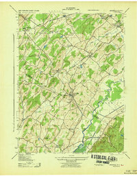
 1943 Franklin Furnace1943 Print · USGSMid-century Sussex County is defined here by its deep mining roots and mountain reservoirs. Trace the industrial landscape of Franklin and Ogdensburg through landmarks like the N J Zinc Co, the Stockholm School, and the Lehigh and Hudson River.
 - 1943 Map of Unionville
 1943 Unionville1943 Print · USGSThe Orange County and Sussex County borderlands come alive in the early 1940s, showing a landscape shaped by rail lines and river valleys. Researchers can trace the industrial footprints of the American Silk Label Co or locate family roots near Minisink Cemetery and Westtown School.
 - 1943 Map of Newfoundland
 1943 Newfoundland1943 Print · USGSThe Pequannock River valley and its surrounding ridges are captured here during the Second World War. Researchers can trace the New York Susquehanna and Western rail line through Newfoundland or locate landmarks like the Fire House and West Milford School.
 - 1943 Map of Greenwood Lake
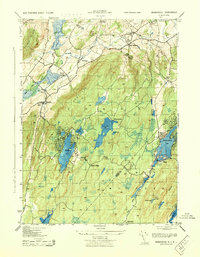
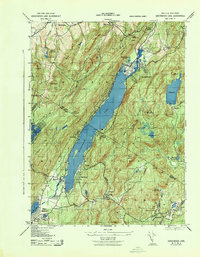 1943 Greenwood Lake1943 Print · USGSGreenwood Lake and the surrounding Highlands are captured during the early 1940s, revealing a landscape defined by iron industry and lakeside settlement. Genealogists and researchers can locate the Ringwood Iron Plant Mine, St Francis School, and the Erie Ringwood Branch railroad.
 - 1943 Map of Wawayanda
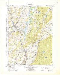
 1943 Wawayanda1943 Print · USGSThe New York and New Jersey borderlands appear here in the early 1940s as a landscape of highland lakes and valley rail stops. Genealogists and local historians can trace the transit corridor of the Lehigh and Hudson River railroad and locate old rural landmarks like the New Milford School and Maple Grange.2 unique versions available
 - 1943 Map of Pine Island
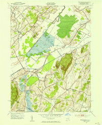
 1943 Pine Island1943 Print · USGSThe fertile black dirt region of the New York-New Jersey border is captured here during the 1940s, showing a landscape defined by rail transit and river engineering. Genealogists and local historians can trace the foundations of Pine Island, locate the St Stanislaus Ch, or follow the industrial footprint of the Universal Atlas Cement Co.
 - 1943 Map of Hamburg, 1944 Print
 1943 Hamburg1944 Print · USGSSussex County's industrial and rail landscape comes alive in this mid-century survey of the Wallkill River valley. Researchers can trace the legacy of the Alderney Milk & Cream Co, various Stone Quarries, and long-standing cemeteries like Fairview Cemetery.
 - 1946 Map of Goshen
 1946 Goshen1946 Print · USGSOrange County was a bustling crossroads of the Erie RR and several other lines during the early twentieth century. Genealogists and local historians can trace family-named hills and vanished rail stops from Pellets Island to Van Burenville and Stony Ford.
End of results
Showing maps 1-9 of 9
Top cities near Vernon Township
- Wayne historical maps
- Warwick historical maps
- Middletown historical maps
- West Milford historical maps
- Rockaway Township historical maps
- Mahwah historical maps
See more
Top neighborhoods of Vernon Township
- Independence Corner historical maps
- Willow Brook historical maps
- Highland Lakes historical maps
- Vernon Valley historical maps
- Wawayanda historical maps
- Glenwood historical maps
See more
Frequently asked questions
- What are the different types of historical maps available for Vernon Township?
- What is the oldest map of Vernon Township?
- Where can I purchase historical maps of Vernon Township for my home or office?
- Where can I download high-res historical maps of Vernon Township?
- Are there historical topographic maps available for Vernon Township?
- Is there historical aerial imagery available for Vernon Township?
- Where are historical maps of Vernon Township sourced from?