1940s Maps of Washington Township, New Jersey
Explore 9 historic maps of Washington Township from the 1940s. These maps offer a rare glimpse into what life looked like during the 1940s — showing old roads, neighborhoods, homes, and landmarks that have changed or disappeared over time.
Whether you're researching your family's past, planning a metal detecting trip, or studying how Washington Township's landscape evolved across the 1940s, these high-resolution maps are a powerful tool for exploring the history of this region.
- Focus on a specific era: All maps on this page are from the 1940s, giving you a focused view of this time period.
- See what’s changed: Compare century-old streets, trails, and buildings to today's modern landscape using overlays and satellite layers.
- Research with precision: Use these maps for genealogy, historical research, land use analysis, or educational projects.
- View, download, or print: Maps are fully viewable online in high resolution, and can be downloaded or printed for your own records.
Start exploring Washington Township's history through authentic maps from the 1940s. This is your window into the past.
Washington Township, NJ maps
(9)- 1941 Map of Delaware Water Gap
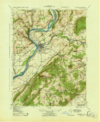
 1941 Delaware Water Gap1941 Print · USGSThe Delaware River valley is captured here in the early 1940s, showing the borderlands of Pennsylvania and New Jersey. Genealogists can trace family names through dozens of rural landmarks like Three Church Hill, Brass Castle, and the Stone Church PO.
 - 1942 Map of Delaware Water Gap
 1942 Delaware Water Gap1942 Print · USGSThe Delaware River gorge and its surrounding ridges come into focus during the early war years, highlighting a critical rail and river junction. Trace local history through family-named landmarks like Miller Ch, rural Quaker Plain Sch, and the unique name of Manunka Chunk.3 unique versions available
 - 1943 Map of High Bridge
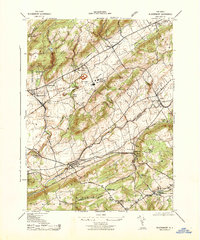
 1943 High Bridge1943 Print · USGSWestern New Jersey industrial and institutional corridors are meticulously mapped here during the early war years. Genealogists and historians can trace family locations near the NJ State Hospital or the Grobelis Farm, and identify vanished local landmarks like the Air Raid Station and Asbury Graphite Refinery.
 - 1943 Map of Washington
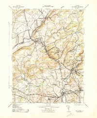
 1943 Washington1943 Print · USGSWarren County at the height of the second World War reveals a busy landscape of industry and rail. Genealogists can trace family names at the Pequest Union Cemetery or find historic workplaces like Oxford Furnace and the Magnetite Mine.
 - 1943 Map of Bethlehem
 1943 Bethlehem1943 Print · USGSNorthampton and Lehigh counties hummed with industry and river commerce during the early war years. Researchers can trace the path of the Lehigh Valley RR, locate family-named landmarks like Chief Tatamy, and find rural schools such as Mexico School and Poplar Valley Sch.
 - 1943 Map of Belvidere
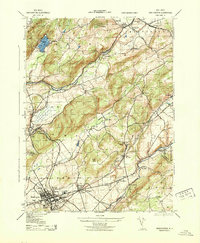
 1943 Belvidere1943 Print · USGSThe river and rail corridors of Warren County define this wartime landscape as it stood in the early 1940s. Genealogists and historians can trace the local industry of Belvidere, the early runways of Martins Creek Airport, and the historic industrial site of Oxford Furnace.
 - 1943 Map of Bloomsbury
 1943 Bloomsbury1943 Print · USGSBloomsbury and the Musconetcong Valley are captured here during the mid-forties, showing a landscape shaped by heavy industry and vital rail corridors. Researchers can trace the massive Edison Portland Cement Co, the path of the Morris Canal, and local landmarks like Kennedy Mills.
 - 1944 Map of Newark, 1971 Print
 1944 Newark1971 Print · USGSThe industrial corridor from Philadelphia to New York was in a period of massive transition during the mid-forties. Genealogists and researchers can trace the rail lines of the Lehigh Valley RR, locate military installations like Picatinny Arsenal, and explore the early sprawl near Levittown.5 unique versions available
 - 1949 Map of Newark
 1949 Newark1949 Print · USGSThe industrial corridor between Philadelphia and New York comes alive in this post-war survey. Genealogists and historians can trace the massive rail networks of the Reading Railroad and locate major installations like Fort Dix or Picatinny Arsenal.2 unique versions available
End of results
Showing maps 1-9 of 9
Top cities near Washington Township
- Hillsborough Township historical maps
- Mount Olive historical maps
- Easton historical maps
- Raritan Township historical maps
- Readington Township historical maps
- Phillipsburg historical maps
See more
Top neighborhoods of Washington Township
- Brass Castle historical maps
- Butler Park historical maps
- Pleasant Valley historical maps
- Port Colden historical maps
- Changewater historical maps
Frequently asked questions
- What are the different types of historical maps available for Washington Township?
- What is the oldest map of Washington Township?
- Where can I purchase historical maps of Washington Township for my home or office?
- Where can I download high-res historical maps of Washington Township?
- Are there historical topographic maps available for Washington Township?
- Is there historical aerial imagery available for Washington Township?
- Where are historical maps of Washington Township sourced from?