1960s Maps of Pie Town, New Mexico
Explore 2 historic maps of Pie Town from the 1960s. These maps offer a rare glimpse into what life looked like during the 1960s — showing old roads, neighborhoods, homes, and landmarks that have changed or disappeared over time.
Whether you're researching your family's past, planning a metal detecting trip, or studying how Pie Town's landscape evolved across the 1960s, these high-resolution maps are a powerful tool for exploring the history of this region.
- Focus on a specific era: All maps on this page are from the 1960s, giving you a focused view of this time period.
- See what’s changed: Compare century-old streets, trails, and buildings to today's modern landscape using overlays and satellite layers.
- Research with precision: Use these maps for genealogy, historical research, land use analysis, or educational projects.
- View, download, or print: Maps are fully viewable online in high resolution, and can be downloaded or printed for your own records.
Start exploring Pie Town's history through authentic maps from the 1960s. This is your window into the past.
Pie Town, NM maps
(2)- 1962 Map of Saint Johns
 1962 Saint Johns1962 Print · USGSEastern Arizona and the New Mexico borderlands come alive in the early sixties, showing a landscape of high-plateau ranching and early national monuments. Trace the path of the Atchison Topeka and Santa Fe or locate old water sources like Salado Springs and Lyman Reservoir.
 - 1967 Map of Pie Town, 1971 Print
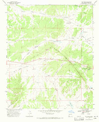 1967 Pie Town1971 Print · USGSHigh in the New Mexico backcountry during the late sixties, this area shows a landscape defined by ranching and the Continental Divide. Trace local history through family-named landmarks like McAllister Draw or the remote Nalda Ranch Landing Field.2 unique versions available
End of results
Showing maps 1-2 of 2
Top cities near Pie Town
Frequently asked questions
- What are the different types of historical maps available for Pie Town?
- What is the oldest map of Pie Town?
- Where can I purchase historical maps of Pie Town for my home or office?
- Where can I download high-res historical maps of Pie Town?
- Are there historical topographic maps available for Pie Town?
- Is there historical aerial imagery available for Pie Town?
- Where are historical maps of Pie Town sourced from?