1960s Maps of Spur Lake, New Mexico
Explore 2 historic maps of Spur Lake from the 1960s. These maps offer a rare glimpse into what life looked like during the 1960s — showing old roads, neighborhoods, homes, and landmarks that have changed or disappeared over time.
Whether you're researching your family's past, planning a metal detecting trip, or studying how Spur Lake's landscape evolved across the 1960s, these high-resolution maps are a powerful tool for exploring the history of this region.
- Focus on a specific era: All maps on this page are from the 1960s, giving you a focused view of this time period.
- See what’s changed: Compare century-old streets, trails, and buildings to today's modern landscape using overlays and satellite layers.
- Research with precision: Use these maps for genealogy, historical research, land use analysis, or educational projects.
- View, download, or print: Maps are fully viewable online in high resolution, and can be downloaded or printed for your own records.
Start exploring Spur Lake's history through authentic maps from the 1960s. This is your window into the past.
Spur Lake, NM maps
(2)- 1962 Map of Clifton
 1962 Clifton1962 Print · USGSThe copper-rich Arizona-New Mexico borderlands come into focus in the early sixties, centered on the mining complexes of Morenci and Clifton. Researchers can trace the Southern Pacific rail lines and locate remote outposts like Honeymoon and the Double Circle Ranch.
 - 1965 Map of Underwood Lake, 1968 Print
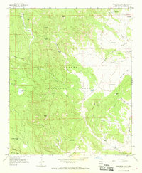 1965 Underwood Lake1968 Print · USGSHigh desert ranching and forest lands in Catron County come alive in the mid-1960s, showing a remote landscape of peaks and water tanks. Genealogists and researchers can locate family sites like Gribble Place and Bastian Ranch, or trace landmarks like the Spur Lake Cem and Underwood Lake.2 unique versions available
End of results
Showing maps 1-2 of 2
Frequently asked questions
- What are the different types of historical maps available for Spur Lake?
- What is the oldest map of Spur Lake?
- Where can I purchase historical maps of Spur Lake for my home or office?
- Where can I download high-res historical maps of Spur Lake?
- Are there historical topographic maps available for Spur Lake?
- Is there historical aerial imagery available for Spur Lake?
- Where are historical maps of Spur Lake sourced from?