1900s (20th Century) Maps of Diamante Mill, New Mexico
Explore 7 historic maps of Diamante Mill from the 1900s (20th Century). These maps offer a rare glimpse into what life looked like during the 1900s — showing old roads, neighborhoods, homes, and landmarks that have changed or disappeared over time.
Whether you're researching your family's past, planning a metal detecting trip, or studying how Diamante Mill's landscape evolved across the 1900s, these high-resolution maps are a powerful tool for exploring the history of this region.
- Focus on a specific era: All maps on this page are from the 1900s, giving you a focused view of this time period.
- See what’s changed: Compare century-old streets, trails, and buildings to today's modern landscape using overlays and satellite layers.
- Research with precision: Use these maps for genealogy, historical research, land use analysis, or educational projects.
- View, download, or print: Maps are fully viewable online in high resolution, and can be downloaded or printed for your own records.
Start exploring Diamante Mill's history through authentic maps from the 1900s. This is your window into the past.
Diamante Mill, NM maps
(7)- 1955 Map of Roswell, 1974 Print
 1955 Roswell1974 Print · USGSSoutheastern New Mexico is shown in transition during the mid-fifties, from the Pecos Valley ranching hubs to the high timber of the Sacramento Mountains. Researchers can trace the Atchison Topeka and Santa Fe RR through Roswell and Hagerman or locate the old barracks at Ft Stanton.3 unique versions available
 - 1956 Map of Diamond A Ranch, 1957 Print
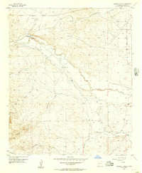 1956 Diamond A Ranch1957 Print · USGSRanching operations in Chaves County were centered on the Rio Hondo during the mid-fifties. Researchers can trace the infrastructure of the Diamond A Ranch and White Ranch through localized landmarks like Diamante Mill and Eighteenmile Mill.2 unique versions available
 - 1958 Map of Roswell
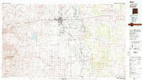
 1958 Roswell1958 Print · USGSThe High Plains and mountain peaks of New Mexico are captured here during the mid-fifties, showing the region before the closure of Walker Air Force Base. Researchers can trace the ranching and rail landscape from Lincoln to the Pecos River valley through Hagerman and Lake Arthur.
 - 1959 Map of Diamond A Ranch, 1985 Print
 1959 Diamond A Ranch1985 Print · USGSChaves County ranching operations are captured here during the mid-twentieth century as the regional water infrastructure was being refined. Researchers can trace historical land use through landmarks like Diamond A Ranch, White Ranch, and numerous pump sites such as Eighteenmile Mill.
 - 1962 Map of Roswell
 1962 Roswell1962 Print · USGSSoutheastern New Mexico in the early sixties shows a landscape defined by high mountain peaks and a growing military presence at Roswell. Genealogists and historians can trace the roads connecting Fort Stanton, Capitan, and the Mescalero Apache Indian Reservation.
 - 1962 Map of Horseshoe Bend, 1964 Print
 1962 Horseshoe Bend1964 Print · USGSRanching and water management define this Chaves County landscape during the early sixties as the regional economy centers on the river. Researchers can trace the legacy of family operations at Mennecke Ranch and Nunez Ranch or locate the Francisco Cordova Homestead (Ruins).
 - 1979 Map of Roswell
 1979 Roswell1979 Print · USGSThe Pecos River valley and the city of Roswell are shown here in the late seventies as the region balanced aviation growth with agricultural heritage. Trace the transition of local sites like Roswell Industrial Air Center and the Atchison Topeka and Santa Fe rail line.
End of results
Showing maps 1-7 of 7
Frequently asked questions
- What are the different types of historical maps available for Diamante Mill?
- What is the oldest map of Diamante Mill?
- Where can I purchase historical maps of Diamante Mill for my home or office?
- Where can I download high-res historical maps of Diamante Mill?
- Are there historical topographic maps available for Diamante Mill?
- Is there historical aerial imagery available for Diamante Mill?
- Where are historical maps of Diamante Mill sourced from?