1960s Maps of Romero Place, New Mexico
Explore 2 historic maps of Romero Place from the 1960s. These maps offer a rare glimpse into what life looked like during the 1960s — showing old roads, neighborhoods, homes, and landmarks that have changed or disappeared over time.
Whether you're researching your family's past, planning a metal detecting trip, or studying how Romero Place's landscape evolved across the 1960s, these high-resolution maps are a powerful tool for exploring the history of this region.
- Focus on a specific era: All maps on this page are from the 1960s, giving you a focused view of this time period.
- See what’s changed: Compare century-old streets, trails, and buildings to today's modern landscape using overlays and satellite layers.
- Research with precision: Use these maps for genealogy, historical research, land use analysis, or educational projects.
- View, download, or print: Maps are fully viewable online in high resolution, and can be downloaded or printed for your own records.
Start exploring Romero Place's history through authentic maps from the 1960s. This is your window into the past.
Romero Place, NM maps
(2)- 1961 Map of Marmon Ranch, 1963 Print
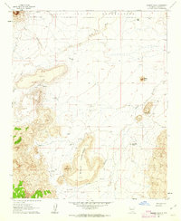 1961 Marmon Ranch1963 Print · USGSThe high-desert ranchlands of the Laguna Indian Reservation come into focus in the early sixties. Researchers can trace the legacy of remote outposts and water management at Marmon Ranch, Alberta Homestead, and the Badger Dam.2 unique versions available
 - 1962 Map of Socorro
 1962 Socorro1962 Print · USGSCentral New Mexico comes alive in the early sixties as the rail-and-river corridor of the Rio Grande connects historic pueblos and ranching towns. Local historians can trace the route of the Atchison Topeka and Santa Fe through Belen or locate the Torrance Mine near Mountainair.
End of results
Showing maps 1-2 of 2
Top cities near Romero Place
Frequently asked questions
- What are the different types of historical maps available for Romero Place?
- What is the oldest map of Romero Place?
- Where can I purchase historical maps of Romero Place for my home or office?
- Where can I download high-res historical maps of Romero Place?
- Are there historical topographic maps available for Romero Place?
- Is there historical aerial imagery available for Romero Place?
- Where are historical maps of Romero Place sourced from?