1990s Maps of Angel Fire, New Mexico
Explore 4 historic maps of Angel Fire from the 1990s. These maps offer a rare glimpse into what life looked like during the 1990s — showing old roads, neighborhoods, homes, and landmarks that have changed or disappeared over time.
Whether you're researching your family's past, planning a metal detecting trip, or studying how Angel Fire's landscape evolved across the 1990s, these high-resolution maps are a powerful tool for exploring the history of this region.
- Focus on a specific era: All maps on this page are from the 1990s, giving you a focused view of this time period.
- See what’s changed: Compare century-old streets, trails, and buildings to today's modern landscape using overlays and satellite layers.
- Research with precision: Use these maps for genealogy, historical research, land use analysis, or educational projects.
- View, download, or print: Maps are fully viewable online in high resolution, and can be downloaded or printed for your own records.
Start exploring Angel Fire's history through authentic maps from the 1990s. This is your window into the past.
Angel Fire, NM maps
(4)- 1994 Map of Garcia Peak, 1998 Print
 1994 Garcia Peak1998 Print · USGSHigh in the Cimarron Range during the 1990s, this area shows the intersection of famous scouting lands and historic land grants. Trace the locations of back-country outposts like Crooked Creek Camp, the Angel Fire Ski Area, and the southern reaches of the Philmont Scout Ranch.
 - 1994 Map of Agua Fria Peak, 1998 Print
 1994 Agua Fria Peak1998 Print · USGSHigh-altitude New Mexico territory in the mid-1990s showcases a rugged landscape of ridges and ranch lands. Researchers can trace the bounds of the Philmont Scout Ranch and historic land grants near Agua Fria Peak and Hidden Lake.
 - 1995 Map of Osha Mountain, 1997 Print
 1995 Osha Mountain1997 Print · USGSThe high peaks and land grants of northern New Mexico are captured here in the mid-1990s as the borders of three counties meet. Genealogists and local historians can trace legacy sites like the San Antonio Ch Cem or navigate the high reaches of Osha Mountain and Valle Largo.
 - 1995 Map of Palo Flechado Pass, 1997 Print
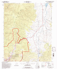 1995 Palo Flechado Pass1997 Print · USGSHigh-altitude mountain passes and historical land grants define this corner of the Sangre de Cristo range in the mid-1990s. Researchers can trace the borders of the Pueblo de Taos Indian Reservation or locate the Angel Fire Ski Area and Agua Fria.2 unique versions available
End of results
Showing maps 1-4 of 4
Top cities near Angel Fire
Top neighborhoods of Angel Fire
Frequently asked questions
- What are the different types of historical maps available for Angel Fire?
- What is the oldest map of Angel Fire?
- Where can I purchase historical maps of Angel Fire for my home or office?
- Where can I download high-res historical maps of Angel Fire?
- Are there historical topographic maps available for Angel Fire?
- Is there historical aerial imagery available for Angel Fire?
- Where are historical maps of Angel Fire sourced from?