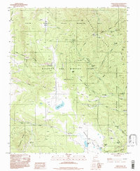
1994 Map of Garcia Peak
USGS Topo · Published 1998About this map
The high Cimarron Range defines this part of Colfax County, where the southern portion of the Philmont Scout Ranch meets the Beaubien and Miranda Grant (Maxwell). This mountainous terrain is characterized by a network of seasonal camps and back-country trails rather than permanent townships. Names like Red Hills Camp, Crooked Creek Camp, and Garcia Cow Camp reflect a landscape dedicated to scouting, conservation, and traditional ranching. The hydrology is dominated by the Agua Fria Creek and Saladon Creek systems, with high-altitude water bodies including Saladon Lake and Middle Lake. To the west, the Angel Fire Ski Area and the Colin Neblett State Wildlife Area mark the edges of recreational and protected lands near Garcia Peak.
Find a feature on this map
42 named features on this map. Tap any name to fly to it.
Don’t see what you’re looking for? This feature index may not catch every label — zoom into the map to look around manually.
Map Details
Editions of this 1994 Garcia Peak Map
This is the sole edition of this map. No revisions or reprints were ever made.
Other maps of this area

1954 · Raton
USGS Topo · 1:250,000

1955 · Ute Park
USGS Topo · 1:62,500

1956 · Tooth Of Time
USGS Topo · 1:62,500

1958 · Raton
USGS Topo · 1:250,000

1963 · Eagle Nest
USGS Topo · 1:24,000

1965 · Osha Mountain
USGS Topo · 1:24,000

1965 · Palo Flechado Pass
USGS Topo · 1:24,000

1982 · Wheeler Peak
USGS Topo · 1:100,000

1983 · Taos
USGS Topo · 1:100,000
1987 · Ute Park
USGS Topo · 1:24,000