1980s Maps of Cimarron, New Mexico
Explore 4 historic maps of Cimarron from the 1980s. These maps offer a rare glimpse into what life looked like during the 1980s — showing old roads, neighborhoods, homes, and landmarks that have changed or disappeared over time.
Whether you're researching your family's past, planning a metal detecting trip, or studying how Cimarron's landscape evolved across the 1980s, these high-resolution maps are a powerful tool for exploring the history of this region.
- Focus on a specific era: All maps on this page are from the 1980s, giving you a focused view of this time period.
- See what’s changed: Compare century-old streets, trails, and buildings to today's modern landscape using overlays and satellite layers.
- Research with precision: Use these maps for genealogy, historical research, land use analysis, or educational projects.
- View, download, or print: Maps are fully viewable online in high resolution, and can be downloaded or printed for your own records.
Start exploring Cimarron's history through authentic maps from the 1980s. This is your window into the past.
Cimarron, NM maps
(4)- 1981 Map of Springer
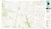 1981 Springer1981 Print · USGSNortheast New Mexico in the early eighties remains a landscape defined by its deep historical pathways and massive land grants. Genealogists and historians can trace the original Santa Fe Trail routes, the State Boys School at Springer, and the landmarks of Wagon Mound.
 - 1981 Map of Raton
 1981 Raton1981 Print · USGSNorthern New Mexico's high mesas and mining corridors are preserved here as they appeared in the early eighties. Genealogists and historians can trace the transit networks of the Santa Fe Trail and find company towns like Van Houten and Koehler.
 - 1987 Map of Coyote Mesa
 1987 Coyote Mesa1987 Print · USGSColfax County's high-country terrain is captured in the late 1980s, showcasing the extensive geography of the Philmont Scout Ranch. Researchers can trace old mountain outposts like Zastrow Camp and Nairn Place or locate landmarks such as Tooth of Time Ridge.
 - 1987 Map of Cimarron
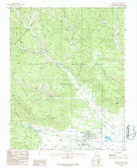 1987 Cimarron1987 Print · USGSCimarron and the surrounding highlands were home to thriving scout camps and ranching operations during the late eighties. Researchers can trace the Old Railroad Grade and locate historical sites like Indian Writings Camp and the Cemetery near the river.
End of results
Showing maps 1-4 of 4
Frequently asked questions
- What are the different types of historical maps available for Cimarron?
- What is the oldest map of Cimarron?
- Where can I purchase historical maps of Cimarron for my home or office?
- Where can I download high-res historical maps of Cimarron?
- Are there historical topographic maps available for Cimarron?
- Is there historical aerial imagery available for Cimarron?
- Where are historical maps of Cimarron sourced from?