1900s (20th Century) Maps of McDaniel Cimarron Place, New Mexico
Explore 5 historic maps of McDaniel Cimarron Place from the 1900s (20th Century). These maps offer a rare glimpse into what life looked like during the 1900s — showing old roads, neighborhoods, homes, and landmarks that have changed or disappeared over time.
Whether you're researching your family's past, planning a metal detecting trip, or studying how McDaniel Cimarron Place's landscape evolved across the 1900s, these high-resolution maps are a powerful tool for exploring the history of this region.
- Focus on a specific era: All maps on this page are from the 1900s, giving you a focused view of this time period.
- See what’s changed: Compare century-old streets, trails, and buildings to today's modern landscape using overlays and satellite layers.
- Research with precision: Use these maps for genealogy, historical research, land use analysis, or educational projects.
- View, download, or print: Maps are fully viewable online in high resolution, and can be downloaded or printed for your own records.
Start exploring McDaniel Cimarron Place's history through authentic maps from the 1900s. This is your window into the past.
McDaniel Cimarron Place, NM maps
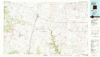
(5)- 1954 Map of Raton, 1963 Print
 1954 Raton1963 Print · USGSNorthern New Mexico's high-country and plains are documented here in the early sixties, showing the region's ranching and mining infrastructure. Trace the legacy of the Maxwell Land Grant, locate remote rural sites like Tafoya School, and follow the Atchison Topeka and Santa Fe Railway through the heart of Raton.3 unique versions available
 - 1956 Map of Miami, 1957 Print
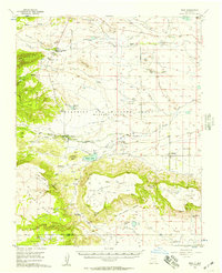 1956 Miami1957 Print · USGSColfax County ranch lands and scout camps come into focus in the mid-1950s, showing the intersection of the Maxwell Grant and early tourism. Trace local genealogy and landmarks at Miami, the Sacred Heart Ch, and the historic Philmont Scout Ranch.4 unique versions available
 - 1958 Map of Raton
 1958 Raton1958 Print · USGSNorthern New Mexico and the Colorado borderlands are mapped here in the late fifties, showcasing a landscape of high peaks and historic land grants. Genealogists and historians can trace families across Picuris Pueblo, find old schoolhouses like Piedra Lumbre School, or follow the Atchison Topeka and Santa Fe rail line.3 unique versions available
 - 1981 Map of Springer
 1981 Springer1981 Print · USGSNortheast New Mexico in the early eighties remains a landscape defined by its deep historical pathways and massive land grants. Genealogists and historians can trace the original Santa Fe Trail routes, the State Boys School at Springer, and the landmarks of Wagon Mound.
 - 1987 Map of Miami NE
 1987 Miami NE1987 Print · USGSNortheastern New Mexico in the late eighties remains a land of massive historical grants and early western transit routes. Researchers can trace the legendary SANTA FE TRAIL as it crosses the Beaubien and Miranda Grant near C S Ranch and the Cimarron River.
End of results
Showing maps 1-5 of 5
Top cities near McDaniel Cimarron Place
Frequently asked questions
- What are the different types of historical maps available for McDaniel Cimarron Place?
- What is the oldest map of McDaniel Cimarron Place?
- Where can I purchase historical maps of McDaniel Cimarron Place for my home or office?
- Where can I download high-res historical maps of McDaniel Cimarron Place?
- Are there historical topographic maps available for McDaniel Cimarron Place?
- Is there historical aerial imagery available for McDaniel Cimarron Place?
- Where are historical maps of McDaniel Cimarron Place sourced from?