1940s Maps of Butterfield Park, New Mexico
Explore 2 historic maps of Butterfield Park from the 1940s. These maps offer a rare glimpse into what life looked like during the 1940s — showing old roads, neighborhoods, homes, and landmarks that have changed or disappeared over time.
Whether you're researching your family's past, planning a metal detecting trip, or studying how Butterfield Park's landscape evolved across the 1940s, these high-resolution maps are a powerful tool for exploring the history of this region.
- Focus on a specific era: All maps on this page are from the 1940s, giving you a focused view of this time period.
- See what’s changed: Compare century-old streets, trails, and buildings to today's modern landscape using overlays and satellite layers.
- Research with precision: Use these maps for genealogy, historical research, land use analysis, or educational projects.
- View, download, or print: Maps are fully viewable online in high resolution, and can be downloaded or printed for your own records.
Start exploring Butterfield Park's history through authentic maps from the 1940s. This is your window into the past.
Butterfield Park, NM maps
(2)- 1941 Map of Organ Peak, 1961 Print
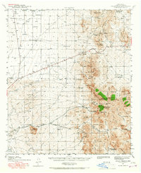 1941 Organ Peak1961 Print · USGSDona Ana County was a land of high desert peaks and isolated ranching outposts in the early 1940s. Genealogists and historians can locate family-named landmarks like the Will F. Isaacs Ranch and Beasley Ranch, or trace the grounds of New Mexico State College.2 unique versions available
 - 1943 Map of Organ Peak
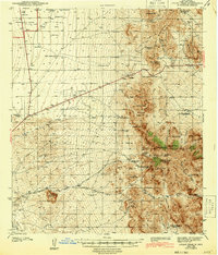 1943 Organ Peak1943 Print · USGSDona Ana County is captured here in the early 1940s, showing the intersection of high desert ranching and the growth of the state college. Genealogists and historians can locate family holdings like Beasley Ranch, the settlement of Organ, and the Modoc Mine.2 unique versions available
End of results
Showing maps 1-2 of 2
Top cities near Butterfield Park
Frequently asked questions
- What are the different types of historical maps available for Butterfield Park?
- What is the oldest map of Butterfield Park?
- Where can I purchase historical maps of Butterfield Park for my home or office?
- Where can I download high-res historical maps of Butterfield Park?
- Are there historical topographic maps available for Butterfield Park?
- Is there historical aerial imagery available for Butterfield Park?
- Where are historical maps of Butterfield Park sourced from?