Old Maps of Chaparral, New Mexico for Academic Research
Study the evolution of Chaparral with 11 high-resolution historic maps. Whether you're teaching, researching, or modeling changes in land use, these maps provide essential visual documentation of urban, environmental, and geographic change.
- Analyze long-term change: Track patterns in development, transportation, and natural features.
- Ideal for environmental or urban studies: Support academic projects with primary historical map data.
- Use in the classroom or lab: Educators and researchers rely on these maps to bring historical context to life.
These maps are a powerful tool for teaching, research, and visualizing how Chaparral has changed over the decades.
Chaparral, NM maps
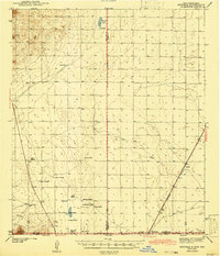
(11)- 1940 Map of Newman, 1965 Print
 1940 Newman1965 Print · USGSThe high desert borderlands near the New Mexico-Texas line come alive in the 1940s, showing a landscape of remote cattle operations and vital rail links. Trace family history through ranch sites like Trueblood Ranch, locate the old Blythe Sch, and follow the Southern Pacific tracks to Newman.
 - 1943 Map of Newman
 1943 Newman1943 Print · USGSThe high desert of the New Mexico and Texas borderlands comes alive in this wartime survey of the ranching country north of El Paso. Genealogists can trace the remote family outposts of the day, including Trueblood Ranch and Manning Ranch, and the isolated Blythe Sch.2 unique versions available
 - 1955 Map of Newman SW, 1962 Print
 1955 Newman SW1962 Print · USGSThe high desert borderlands of New Mexico and Texas are revealed in the mid-1950s as they functioned under military and ranching use. Genealogists and historians can trace remote desert landmarks like Quake Lake, a small Cem, and isolated sites such as Jessie Well and local Ruins.
 - 1955 Map of Las Cruces, 1963 Print
 1955 Las Cruces1963 Print · USGSSouthern New Mexico comes into focus during the mid-fifties, showing the growth of Las Cruces alongside major military and scientific installations. Genealogists and historians can trace the Southern Pacific tracks through small rail towns like Cambray and Afton, or locate family sites near Hatch and Deming.3 unique versions available
 - 1958 Map of Las Cruces
 1958 Las Cruces1958 Print · USGSSouthern New Mexico in the late fifties was a landscape of rapid scientific and military growth centered on the Rio Grande. Local historians can trace the development of Las Cruces, the campus of New Mexico A and M College, and remote rail sidings like Aden Siding.
 - 1982 Map of Las Cruces
 1982 Las Cruces1982 Print · USGSThe Rio Grande valley and the Organ Mountains define this 1980s portrait of southern New Mexico's ranching and military landscape. Trace historic land divisions like the Brazito Grant alongside landmarks such as Santo Tomas and the Silver King Mine.
 - 2010 Map of Newman SW, 2010 Print
 2010 Newman SW2010 Print · USGSCovers Chaparral, including El Paso, Doña Ana County, and other nearby areas
 - 2013 Map of Newman SW, 2013 Print
 2013 Newman SW2013 Print · USGSCovers Chaparral, including El Paso, Doña Ana County, and other nearby areas
 - 2017 Map of Newman SW, 2017 Print
 2017 Newman SW2017 Print · USGSCovers Chaparral, including El Paso, Doña Ana County, and other nearby areas
 - 2020 Map of Newman SW, 2020 Print
 2020 Newman SW2020 Print · USGSCovers Chaparral, including El Paso, Doña Ana County, and other nearby areas
 - 2023 Map of Newman SW, 2023 Print
 2023 Newman SW2023 Print · USGSChaparral and the surrounding desert landscape are shown in the early twenty-first century as the residential grid expands near the Texas border. Researchers can locate the Tompkins Family Cem and Desert View Cem near Fort Bliss.
End of results
Showing maps 1-11 of 11
Top cities near Chaparral
- El Paso historical maps
- Sunland Park historical maps
- Anthony, NM historical maps
- Anthony historical maps
- Canutillo historical maps
- Anthony historical maps
See more
Frequently asked questions
- What are the different types of historical maps available for Chaparral?
- What is the oldest map of Chaparral?
- Where can I purchase historical maps of Chaparral for my home or office?
- Where can I download high-res historical maps of Chaparral?
- Are there historical topographic maps available for Chaparral?
- Is there historical aerial imagery available for Chaparral?
- Where are historical maps of Chaparral sourced from?